| |||||||||||||||||||||||||||||||||||||||||||||||||||||||||||||
| |||||||||||||||||||||||||||||||||||||||||||||||||||||||||||||
| |||||||||||||||||||||||||||||||||||||||||||||||||||||||||||||
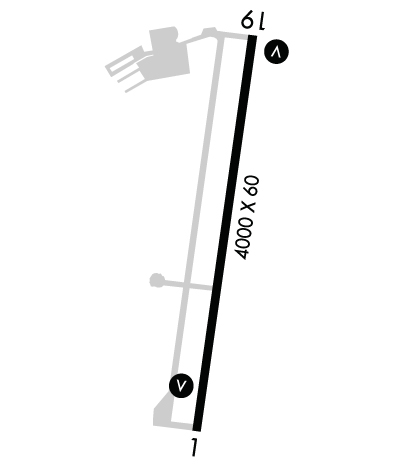
| Rwy | Rwy | |||||||
| 4000x60 | 3947' | 4000x60 | 4000' | |||||
| Runway ID | Single Wheel | Double Wheel | Double Tandem Wheel | Dual Double Wheel |
| 01/19 | N/A | N/A | N/A | N/A |
| These numbers are Advisory and are not limits. The Airport Manager should have more accurate Weight Limits | ||||
 Airport Diagram might not be current. | |
| Facility Name: | KENT STATE UNIVERSITY |
| City Name: | KENT |
| County: | SUMMIT |
| State abbrev: | OH |
| State Name: | OHIO |
| Ownership: | PUBLICLY OWNED |
| Use: | OPEN TO THE PUBLIC |
| Owner's Name: | KENT STATE UNIVERSITY; AIRPORT@KENT.EDU. |
| Address: | 4020 KENT RD |
| STOW, OH 44224-4200 | |
| Owner's Phone: | 330-672-2640; ADNL INFO: WWW.KENT.EDU/AIRPORT. |
| Manager's Name: | DAVID POLUGA |
| Address: | 4020 KENT RD |
| STOW, OH 44224-4200 | |
| Phone: | 330-672-1943 |
| FAA Region: | GREAT LAKES |
| FAA Field Office: | DET |
| Date | Sunrise | Sunset |
|---|---|---|
| 04/23/24 Tuesday | 6:33 | 20:15 |
| 04/24/24 Wednesday | 6:32 | 20:16 |
| 04/25/24 Thursday | 6:30 | 20:17 |
| 04/26/24 Friday | 6:29 | 20:18 |
| 04/27/24 Saturday | 6:28 | 20:19 |
| 04/28/24 Sunday | 6:26 | 20:20 |
| 04/29/24 Monday | 6:25 | 20:21 |
| 04/30/24 Tuesday | 6:24 | 20:22 |
| 05/01/24 Wednesday | 6:22 | 20:24 |
| 05/02/24 Thursday | 6:21 | 20:25 |
| 05/03/24 Friday | 6:20 | 20:26 |
| 05/04/24 Saturday | 6:19 | 20:27 |
| 05/05/24 Sunday | 6:17 | 20:28 |
| 05/06/24 Monday | 6:16 | 20:29 |
| Airport Attendance Schedule | MON-FRI 0630-DUSK, SAT-SUN 0800-DUSK; CLSD DEC 25 & JAN 1. |
| Airport Status | OPERATIONAL (This Status can change at any time - please check NOTAMS) |
| Airport Lighting Schedule | ACTVT REIL RWY 01 & 19; VASI RWY 01 & 19; MIRL RWY 01/19 - 122.9. |
| Airport Storage Available | Tie Downs, Hanger |
| Extra Services Available | Flight Instruction, Aircraft Rental |
| Wind Indicator | YES - (lighted) |
| Control Tower | NO |
| CTAF Frequency | 122.725 |
| Unicom Frequency | 122.725 |
| Rotating Beacon Color | WG |
| Segmented Circle | NO |
| Landing Fee | NO; RAMP FEE FOR MULTI-ENG ACFT - WAIVED WITH FUEL PURCHASE. |
| Airport Inspected | STATE - performed by STATE AERONAUTICAL PERSONNEL |
| Inspection Date | 09/17/2020 |
| Type of Fuel Available | Grade 100LL; -10AVBL ONLY WHEN ATNDD, SELF SER UNAVBL. |
| Airframe Repair Service | NONE |
| Power Plant Repair Service | NONE |
| Latitude | N4109.1 |
| Longitude | W08124.9 (ESTIMATED) |
| Arpt Elevation | 1134ft (SURVEYED) |
| Magnetic Variation | 07W |
| 3 miles W | of KENT |
| Traffic Pattern Altitude | 850 |
| Sectional Chart | DETROIT |
| Operations (Reported) | Yearly | Avg. Daily |
|---|---|---|
| General Aviation Transient | 11100 | 30 |
| General Aviation Local | 59400 | 163 |
| Air Taxi | 1800 | 5 |
| Commerical | 0 | 0 |
| Commuter | 0 | 0 |
| Military | 200 | 1 |
| Aircraft based on Field | |
|---|---|
| General Aviation Singles | 37 |
| General Aviation Multi | 2 |
| Jet Aircraft | 0 |
| General Aviation Helicopters | 0 |
| Military Aircraft | 0 |
| Gliders | 0 |
| Ultralights | 0 |
| FSS on field | NO |
| FSS tie-in | CLEVELAND |
| FSS Phone | 1-800-WX-BRIEF |
| Who issues Notams | CLE |
| Notam D service at airport | YES |
| ARTCC Name | CLEVELAND |
| Airport Certification | |
| Aircraft Rescue & Firefighting Index | None |
| Airport of Entry | No |
| Custom Landing Rights | No |
| Joint Civil/Military | No |
| Military Landing rights | YES |
| NATIONAL PLAN OF INTEGRATED AIRPORT SYSTEMS (NPIAS) |
| GRANT AGREEMENTS UNDER FAAP/ADAP/AIP |
| ASSURANCES PURSUANT TO TITLE VI, CIVIL RIGHTS ACT OF 1964 |
| OCNL DEER, BIRDS & OTR WILDLIFE ON & INVOF ARPT. |
| FOR NOISE ABATEMENT PROCS CALL AMGR. |
| FOR CD CTC CLEVELAND ARTCC AT 440-774-0223. |
| HVY STUDENT TRG ACT. |
| RWY 19 CALM WIND RWY. |
Airport Communications & Frequencies:
| |||||||||||||||||||
| Runway: 01 | Runway: 19 | ||
| Mag heading: | 16° | Mag heading: | 196° |
| Rwy Slope: | .44% Up | Rwy Slope: | -.44% Down |
| Approach: | Approach: | ||
| Pattern: | Left Traffic | Pattern: | Left Traffic |
| Markings: | NONPRECISION INSTRUMENT | Markings: | NONPRECISION INSTRUMENT |
| Marking Condition: | FAIR | Marking Condition: | FAIR |
| Arresting Dev: | Arresting Dev: | ||
| Lat & Long: | N4108.8 W08125.0 | Lat. & Long.: | N4109.4 W08124.8 |
| Elev: | 1116.4 ft. MSL | Elev: | 1134.0 ft. MSL |
| TCH: | 42 ft. AGL | TCH: | 35 ft. AGL |
| Visual Glide Path: | 3.50 degrees | Visual Glide Path: | 3.00 degrees |
| Displaced Threshold: | 53 feet | Displaced Threshold: | No |
| Touchdown Zone: | YES | Touchdown Zone: | YES |
| Touchdown Elev.: | 1128.6 feet | Touchdown Elev.: | 1134.4 feet |
| Visual Glide Slope: | 4-BOX VASI ON LEFT SIDE OF RUNWAY | Visual Glide Slope: | 4-BOX VASI ON LEFT SIDE OF RUNWAY |
| RVR Equipment: | RVR Equipment: | ||
| RVV Equipment: | NO | RVV Equipment: | NO |
| Approach Lights: | Approach Lights: | ||
| REIL: | YES | REIL: | YES |
| Centerline Lights: | NO | Centerline Lights: | NO |
| Touchdown lights: | NO | Touchdown lights: | NO |
| Runway Category: | Runway with a Non-precision Approach | Runway Category: | Runway with a Non-precision Approach |
| Declared Distances: | Declared Distances: | ||
| Obstructions: | TREES | Obstructions: | TREES |
| Marked: | NOT Marked/Lighted | Marked: | NOT Marked/Lighted |
| Clearance slope: | 14:1; APCH RATIO 16:1 TO DTHR DUE TO +122 FT TREE, 1993 FT DIST, 364 FT L. | Clearance slope: | 15:1 |
| Obstruction height: | 122 feet AGL | Obstruction height: | 88 feet AGL |
| Dist. from runway: | 1993 feet | Dist. from runway: | 1586 feet |
| Centerline offset: | 364 left of centerline | Centerline offset: | 239 feet right of centerline |
| Comments: | Comments: |