Click here for more info on on SMS!

K1G1

ELYRIA
ELYRIA
OH
Time Zone: Eastern
Lat: N 4119.9
Long: W 08206.0
Elev: 758
Var: +06
Longest Runway: 3053
Clr Del: 125.7
CTAF: 122.8

FBO & Flight Services info for K1G1

FBOs: Update your Fuel Prices

ELYRIA AIRPORTPh: 440-343-4943
-
-
Service
Jet
100LL
SAF
MoGas
Full        Last Update: 04/05/2024 08:52

Self  6.25    
 Address: 10800 MIDDLE AVE   ELYRIA, OH 44035
If you are an FBO, call 1-203-262-1700 to update your info or email: FltPlan.Advertising@garmin.com
Advertise your FBO on FltPlan.com

Runway & Approach Info for K1G1
Rwy
Length
Land Dist**
Approach*
  Rwy
Length
Land Dist**
Approach*
09
3053x48  3053'          
 
  
27
  3053x48  3053'          
 
 * only ILS, LOC, LDA, and SDF approaches to a specific runway are shown
** For any Declared Landing Distance Available, please see A/FD or Approach plates
Runway Weight Capability (lbs.) Help
Runway IDSingle WheelDouble WheelDouble Tandem WheelDual Double Wheel
09/27N/AN/AN/AN/A
These numbers are Advisory and are not limits.   The Airport Manager should have more accurate Weight Limits
Approach Charts
Approaches    
Current Weather/Notams
Customs Information Send updates to Support@FltPlan.com
Customs Not Available
Database effective 05/16/2024
Airport Diagram of K1G1
Airport Diagram might not be current.

Facility Name: ELYRIA
City Name: ELYRIA
County: LORAIN
State abbrev: OH
State Name: OHIO
   
Ownership: PRIVATELY OWNED
Use: OPEN TO THE PUBLIC
Owner's Name: ANGELO A GOUSIOS
Address: 3593 MEDINA RD #319
 MEDINA, OH 44256-8182
Owner's Phone: 440-343-4393
  
Manager's Name: ANGELO GOUSIOS
Address: 3593 MEDINA RD #319; ARPT PHYS ADS: 10800 MIDDLE AVE, ELYRIA, OH 44035.
 MEDINA, OH 44256-8182
Phone: 440-343-4943; OR 440-343-0454.
   
FAA Region: GREAT LAKES
FAA Field Office: DET


Sunrise / Sunset times for ELYRIA

DateSunriseSunset
04/24/24 Wednesday6:3420:19
04/25/24 Thursday6:3320:20
04/26/24 Friday6:3120:21
04/27/24 Saturday6:3020:22
04/28/24 Sunday6:2920:23
04/29/24 Monday6:2720:25
04/30/24 Tuesday6:2620:26
05/01/24 Wednesday6:2520:27
05/02/24 Thursday6:2320:28
05/03/24 Friday6:2220:29
05/04/24 Saturday6:2120:30
05/05/24 Sunday6:2020:31
05/06/24 Monday6:1920:32
05/07/24 Tuesday6:1720:33

Airport Facilities

Airport Attendance ScheduleMON-FRI 0800-1700
Airport Status OPERATIONAL (This Status can change at any time - please check NOTAMS)
Airport Lighting ScheduleSS-SR
Airport Storage AvailableNONE
Extra Services AvailableAvionics
Wind IndicatorYES - (unlit)
Control TowerNO
CTAF Frequency122.800
Unicom Frequency122.800
Rotating Beacon ColorWG
Segmented CircleNO
Landing FeeNO

Airport Inspection Data

Airport InspectedSTATE - performed by PRIVATE CONTRACT PERSONNEL
Inspection Date07/14/2021

Airport Services

Type of Fuel AvailableGrade 100LL; -10FUEL AVBL H24 VIA CREDIT CARD.
Airframe Repair ServiceMAJOR
Power Plant Repair ServiceMAJOR

Geographic Data

LatitudeN4119.9
LongitudeW08206.0 (ESTIMATED)
Arpt Elevation757ft (SURVEYED)
Magnetic Variation06W
2 miles Sof ELYRIA
Traffic Pattern Altitude
Sectional ChartDETROIT

Aircraft Data

Operations (Reported)YearlyAvg. Daily
General Aviation Transient 350010
General Aviation Local 1000027
Air Taxi 8002
Commerical 00
Commuter 00
Military 00
Aircraft based on Field
General Aviation Singles 66
General Aviation Multi 1
Jet Aircraft 0
General Aviation Helicopters 0
Military Aircraft 0
Gliders 0
Ultralights 0

FAA Services

FSS on field NO
FSS tie-in CLEVELAND
FSS Phone 1-800-WX-BRIEF
Who issues Notams CLE
Notam D service at airport YES
ARTCC Name CLEVELAND

Federal Status

Airport Certification
Aircraft Rescue & Firefighting IndexNone
Airport of EntryNo
Custom Landing RightsNo
Joint Civil/MilitaryNo
Military Landing rightsNo

Remarks

THIS AIRPORT HAS BEEN SURVEYED BY THE NATIONAL GEODETIC SURVEY.
DEER & BIRDS ON & INVOF ARPT.
FOR CD CTC CLEVELAND APCH AT 216-352-2323.
RWY 09/2 7 NSTD LIRL DUE TO 18 INCH NON-FRANGIBLE MOUNTING STAKES.
Airport Communications & Frequencies:
Clearance Delivery Frequencies:
125.7
CTAF Frequency:
122.800
Unicom Frequency:
122.800
CLEVELAND Primary Approach Frequencies:  
125.35
346.325
CLEVELAND Primary Departure Frequencies:  
125.35
346.325
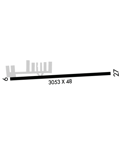
Runway Identifications
Runway Identification: 09/27
Length: 3053 ft
Width: 48 ft
Surface: ASPHALT
Edge lights: Non-Standard Lighting System

Treatment: NONE

 Runway: 09   Runway: 27
Mag heading: 91°Mag heading: 271°
Rwy Slope: .06% UpRwy Slope: -.06% Down
Approach: Approach:
Pattern: Left TrafficPattern: Left Traffic
Markings: BASICMarkings: BASIC
Marking Condition: GOODMarking Condition: GOOD
Arresting Dev: Arresting Dev:
Lat & Long: N4119.9  W08206.3Lat. & Long.: N4119.9  W08205.7
Elev: 755.7 ft. MSLElev: 757.6 ft. MSL
TCH: TCH:
Visual Glide Path: Visual Glide Path:
Displaced Threshold: NoDisplaced Threshold: No
Touchdown Zone: YESTouchdown Zone: YES
Touchdown Elev.: 757.8 feetTouchdown Elev.: 757.8 feet
Visual Glide Slope: Visual Glide Slope:
RVR Equipment: RVR Equipment:
RVV Equipment: NORVV Equipment: NO
Approach Lights: Approach Lights:
REIL: NOREIL: NO
Centerline Lights: NOCenterline Lights: NO
Touchdown lights: NOTouchdown lights: NO
Runway Category: Runway with a Visual ApproachRunway Category: Runway with a Visual Approach
Declared Distances: Declared Distances:
Obstructions: TREEObstructions: TREE
Marked: NOT Marked/LightedMarked: NOT Marked/Lighted
Clearance slope: Clearance slope:
Obstruction height: 85 feet AGLObstruction height: 85 feet AGL
Dist. from runway: 201 feetDist. from runway: 201 feet
Centerline offset: 105 right of centerlineCenterline offset: 125 feet left of centerline
Comments: 10 FT BRUSH & 70 FT TREES, 100-199 FT DIST, 102 FT R.Comments:
C:1/P: