Current Weather/Notams (Metars, TAFs, Notams, NWS Forecast, PIREPS, and nearby weather)
Customs Information Send updates to Support@FltPlan.com
Customs Not Available
Database effective 04/18/2024
Airport Diagram might not be current.
|
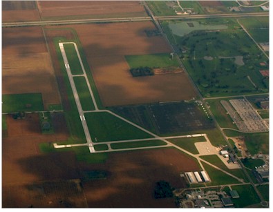
| Facility Name: | WOOD COUNTY |
| City Name: | BOWLING GREEN |
| County: | WOOD |
| State abbrev: | OH |
| State Name: | OHIO |
| | |
| Ownership: | PUBLICLY OWNED |
| Use: | OPEN TO THE PUBLIC |
| Owner's Name: | WOOD CO ARPT AUTH |
| Address: | 1261 E POE RD |
| | BOWLING GREEN, OH 43402-9392 |
| Owner's Phone: | 419-354-2908 |
| | |
| Manager's Name: | MARK BLACK |
| Address: | 1261 E POE RD |
| | BOWLING GREEN, OH 43402-9392 |
| Phone: | 419-354-2908; 419-494-2663. |
| | |
| FAA Region: | GREAT LAKES |
| FAA Field Office: | DET |
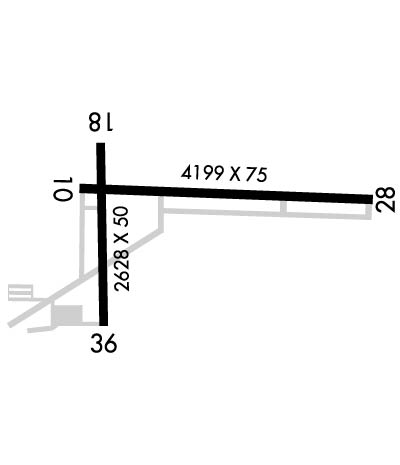
Runway Identifications
Runway Identification: 10/28Length: 4199 ft
Width: 75 ft
Surface: ASPHALT-GOOD CONDITION
Edge lights: Medium IntensityTreatment: NONE
| | Runway: 10 | | Runway: 28 |
| Mag heading: | 96° | Mag heading: | 276° |
| Rwy Slope: | .00% Up | Rwy Slope: | .00% Down |
| Approach: | | Approach: | |
| Pattern: | Left Traffic | Pattern: | Right Traffic |
| Markings: | NONPRECISION INSTRUMENT | Markings: | NONPRECISION INSTRUMENT |
| Marking Condition: | GOOD | Marking Condition: | GOOD |
| Arresting Dev: | | Arresting Dev: | |
| Lat & Long: | N4123.5 W08338.1 | Lat. & Long.: | N4123.5 W08337.2 |
| Elev: | 671.5 ft. MSL | Elev: | 671.6 ft. MSL |
| TCH: | 41 ft. AGL | TCH: | 40 ft. AGL |
| Visual Glide Path: | 3.00 degrees | Visual Glide Path: | 3.00 degrees |
| Displaced Threshold: | No | Displaced Threshold: | No |
| Touchdown Zone: | YES | Touchdown Zone: | YES |
| Touchdown Elev.: | 673.0 feet | Touchdown Elev.: | 673.0 feet |
| Visual Glide Slope: | 2-Light PAPI on LEFT side of Runway | Visual Glide Slope: | 2-Light PAPI on LEFT side of Runway |
| RVR Equipment: | | RVR Equipment: | |
| RVV Equipment: | NO | RVV Equipment: | NO |
| Approach Lights: | | Approach Lights: | |
| REIL: | YES | REIL: | YES |
| Centerline Lights: | NO | Centerline Lights: | NO |
| Touchdown lights: | NO | Touchdown lights: | NO |
| Runway Category: | Runway with a Non-precision Approach | Runway Category: | Runway with a Non-precision Approach |
| Declared Distances: | | Declared Distances: | |
| Obstructions: | CROPS | Obstructions: | CROPS |
| Marked: | NOT Marked/Lighted | Marked: | NOT Marked/Lighted |
| Clearance slope: | | Clearance slope: | |
| Obstruction height: | 8 feet AGL | Obstruction height: | 8 feet AGL |
| Dist. from runway: | 201 feet | Dist. from runway: | 201 feet |
| Centerline offset: | 200 right of centerline | Centerline offset: | 135 feet right of centerline |
| Comments: | OBST CLNC SLP 0:1 DUE TO +8 FT CROPS/CULTIVATED FLD, 50-200 FT DIST, 200 FT R. | Comments: | OBST CLNC SLP 0:1 DUE TO +8 FT CROPS/CULTIVATED FLD, 0-200 FT DIST, 135 FT L/R. |
Runway Identification: 18/36Length: 2628 ft
Width: 50 ft
Surface: ASPHALT-GOOD CONDITION
Edge lights: Medium IntensityTreatment: NONE
| | Runway: 18 | | Runway: 36 |
| Mag heading: | 184° | Mag heading: | 4° |
| Rwy Slope: | .00% | Rwy Slope: | .00% |
| Approach: | | Approach: | |
| Pattern: | Left Traffic | Pattern: | Right Traffic |
| Markings: | NONPRECISION INSTRUMENT | Markings: | NONPRECISION INSTRUMENT |
| Marking Condition: | GOOD | Marking Condition: | GOOD |
| Arresting Dev: | | Arresting Dev: | |
| Lat & Long: | N4123.6 W08338.1 | Lat. & Long.: | N4123.2 W08338.1 |
| Elev: | 671.4 ft. MSL | Elev: | 671.4 ft. MSL |
| TCH: | 38 ft. AGL | TCH: | |
| Visual Glide Path: | 3.00 degrees | Visual Glide Path: | |
| Displaced Threshold: | No | Displaced Threshold: | 68 feet |
| Touchdown Zone: | YES | Touchdown Zone: | YES |
| Touchdown Elev.: | 672.2 feet | Touchdown Elev.: | 672.2 feet |
| Visual Glide Slope: | 4-Light PAPI on LEFT side of Runway | Visual Glide Slope: | |
| RVR Equipment: | | RVR Equipment: | |
| RVV Equipment: | NO | RVV Equipment: | NO |
| Approach Lights: | | Approach Lights: | |
| REIL: | YES | REIL: | NO |
| Centerline Lights: | NO | Centerline Lights: | NO |
| Touchdown lights: | NO | Touchdown lights: | NO |
| Runway Category: | Runway with a Non-precision Approach | Runway Category: | Runway with a Non-precision Approach |
| Declared Distances: | | Declared Distances: | |
| Obstructions: | CROPS | Obstructions: | ROAD |
| Marked: | NOT Marked/Lighted | Marked: | NOT Marked/Lighted |
| Clearance slope: | | Clearance slope: | 4:1; RWY 36 OBST CLNS SLOPE 20:1 TO DTHLD DUE TO +17FT ROAD 280FT FM RWY 36 260FT L / R |
| Obstruction height: | 8 feet AGL | Obstruction height: | 17 feet AGL |
| Dist. from runway: | 201 feet | Dist. from runway: | 280 feet |
| Centerline offset: | 150 right of centerline | Centerline offset: | 260 feet right of centerline |
| Comments: | OBST CLNC SLP 0:1 DUE TO +8 FT CROPS/CULTIVATED FLD, 0-200 FT DIST, 150 FT L/R. | Comments: | RWY 36 OBST CLNS SLOPE 0:1 DUE TO +8FT CROPS/CULTIVATED FIELD 200FT FM EXTENDING TO THLD RWY 36, 125FT R |