Current Weather/Notams (Metars, TAFs, Notams, NWS Forecast, PIREPS, and nearby weather)
Customs Information Send updates to Support@FltPlan.com
Customs Not Available
Database effective 05/16/2024
Airport Diagram might not be current.
|
| Facility Name: | MADILL MUNI |
| City Name: | MADILL |
| County: | MARSHALL |
| State abbrev: | OK |
| State Name: | OKLAHOMA |
| | |
| Ownership: | PUBLICLY OWNED |
| Use: | OPEN TO THE PUBLIC |
| Owner's Name: | CITY OF MADILL |
| Address: | CITY HALL, 201 E. OVERTON |
| | MADILL, OK 73446 |
| Owner's Phone: | 580-795-5586 |
| | |
| Manager's Name: | DAVID MCDANIEL |
| Address: | CITY HALL, 201 E. OVERTON |
| | MADILL, OK 73446 |
| Phone: | 580-795-4017 |
| | |
| FAA Region: | SOUTHWEST |
| FAA Field Office: | AOK |
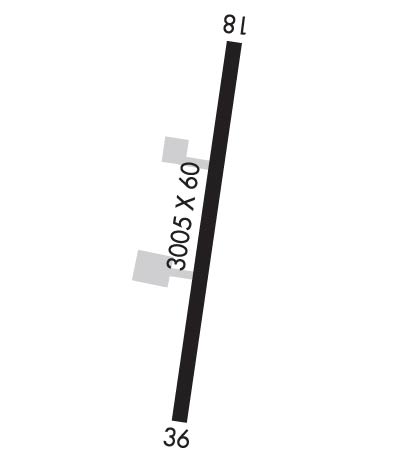
Runway Identifications
Runway Identification: 18/36Length: 3005 ft
Width: 60 ft
Surface: ASPHALT-GOOD CONDITION
Edge lights: Medium IntensityTreatment: NONE
| | Runway: 18 | | Runway: 36 |
| Mag heading: | 180° | Mag heading: | 0° |
| Rwy Slope: | .63% Up | Rwy Slope: | -.63% Down |
| Approach: | | Approach: | |
| Pattern: | Left Traffic | Pattern: | Left Traffic |
| Markings: | NONPRECISION INSTRUMENT | Markings: | NONPRECISION INSTRUMENT |
| Marking Condition: | GOOD | Marking Condition: | GOOD |
| Arresting Dev: | | Arresting Dev: | |
| Lat & Long: | N3408.7 W09648.7 | Lat. & Long.: | N3408.2 W09648.8 |
| Elev: | 862.0 ft. MSL | Elev: | 881.0 ft. MSL |
| TCH: | | TCH: | |
| Visual Glide Path: | | Visual Glide Path: | |
| Displaced Threshold: | No | Displaced Threshold: | No |
| Touchdown Zone: | YES | Touchdown Zone: | YES |
| Touchdown Elev.: | 890.0 feet | Touchdown Elev.: | 890.0 feet |
| Visual Glide Slope: | | Visual Glide Slope: | |
| RVR Equipment: | | RVR Equipment: | |
| RVV Equipment: | NO | RVV Equipment: | NO |
| Approach Lights: | | Approach Lights: | |
| REIL: | YES; LEFT SIDE REIL OTS INDEFLY. | REIL: | YES |
| Centerline Lights: | NO | Centerline Lights: | NO |
| Touchdown lights: | NO | Touchdown lights: | NO |
| Runway Category: | Runway with a Non-precision Approach | Runway Category: | Runway with a Visual Approach |
| Declared Distances: | | Declared Distances: | |
| Obstructions: | TREES | Obstructions: | TREE |
| Marked: | NOT Marked/Lighted | Marked: | NOT Marked/Lighted |
| Clearance slope: | 16:1 | Clearance slope: | 3:1 |
| Obstruction height: | 27 feet AGL | Obstruction height: | 16 feet AGL |
| Dist. from runway: | 651 feet | Dist. from runway: | 257 feet |
| Centerline offset: | 130 right of centerline | Centerline offset: | 99 feet left of centerline |
| Comments: | +5 FT FENCE 0 FT FM RY END 178 FT LEFT. | Comments: | +5 FT FENCE 0 FT FM RY END 220 FT RIGHT. |

