Click here for more info on on SMS!

K1D2

CANTON-PLYMOUTH-METTETAL
PLYMOUTH
MI
Time Zone: Eastern
Lat: N 4220.9
Long: W 08327.4
Elev: 696
Var: +05
Longest Runway: 2302
CTAF: 122.7

FBO & Flight Services info for K1D2

FBOs: Update your Fuel Prices

CANTON-PLYMOUTHPh: 734-459-0012
-
-
Service
Jet
100LL
SAF
MoGas
Full        Last Update: 04/01/2024 09:59

Self  5.70    
 Address: 8550 NORTH LILLEY RD   CANTON, MI 48187
If you are an FBO, call 1-203-262-1700 to update your info or email: FltPlan.Advertising@garmin.com
Advertise your FBO on FltPlan.com

Runway & Approach Info for K1D2
Rwy
Length
Land Dist**
Approach*
  Rwy
Length
Land Dist**
Approach*
18
2302x75  2302'          
 
  
36
  2302x75  2302'          
 
 * only ILS, LOC, LDA, and SDF approaches to a specific runway are shown
** For any Declared Landing Distance Available, please see A/FD or Approach plates
Runway Weight Capability (lbs.) Help
Runway IDSingle WheelDouble WheelDouble Tandem WheelDual Double Wheel
18/3612,500N/AN/AN/A
These numbers are Advisory and are not limits.   The Airport Manager should have more accurate Weight Limits
Approach Charts
Approaches    
Current Weather/Notams
Customs Information Send updates to Support@FltPlan.com
Customs Not Available
Database effective 05/16/2024
Airport Diagram of K1D2
Airport Diagram might not be current.
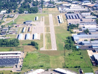
Facility Name: CANTON-PLYMOUTH-METTETAL
City Name: PLYMOUTH
County: WAYNE
State abbrev: MI
State Name: MICHIGAN
   
Ownership: PUBLICLY OWNED
Use: OPEN TO THE PUBLIC
Owner's Name: STATE OF MICHIGAN - MDOT
Address: 2700 PORT LANSING RD
 LANSING, MI 48906-2172
Owner's Phone: 517-335-8521
  
Manager's Name: JIM MORENCY
Address: 8550 N LILLEY RD
 CANTON, MI 48187-2043
Phone: 734-459-0012
   
FAA Region: GREAT LAKES
FAA Field Office: DET


Sunrise / Sunset times for CANTON-PLYMOUTH-METTETAL

DateSunriseSunset
04/24/24 Wednesday6:3820:26
04/25/24 Thursday6:3620:28
04/26/24 Friday6:3520:29
04/27/24 Saturday6:3420:30
04/28/24 Sunday6:3220:31
04/29/24 Monday6:3120:32
04/30/24 Tuesday6:2920:33
05/01/24 Wednesday6:2820:34
05/02/24 Thursday6:2720:35
05/03/24 Friday6:2520:36
05/04/24 Saturday6:2420:38
05/05/24 Sunday6:2320:39
05/06/24 Monday6:2220:40
05/07/24 Tuesday6:2020:41

Airport Facilities

Airport Attendance ScheduleMON-FRI 0700-1600, SAT-SUN ON CALL
Airport Status OPERATIONAL (This Status can change at any time - please check NOTAMS)
Airport Lighting ScheduleACTVT PAPI RWY 18 & 36; MIRL RWY 18/36 - CTAF.
Airport Storage AvailableTie Downs, Hanger
Extra Services AvailableNONE
Wind IndicatorYES - (lighted)
Control TowerNO
CTAF Frequency122.700
Unicom Frequency122.700
Rotating Beacon ColorWG
Segmented CircleYES
Landing FeeNO

Airport Inspection Data

Airport InspectedSTATE - performed by STATE AERONAUTICAL PERSONNEL
Inspection Date08/04/2021

Airport Services

Type of Fuel AvailableGrade 100LL; -10AVBL H24 SELF SVC.
Airframe Repair ServiceNONE
Power Plant Repair ServiceNONE

Geographic Data

LatitudeN4220.9
LongitudeW08327.4 (ESTIMATED)
Arpt Elevation696ft (SURVEYED)
Magnetic Variation05W
2 miles Sof PLYMOUTH
Traffic Pattern Altitude
Sectional ChartDETROIT

Aircraft Data

Operations (Reported)YearlyAvg. Daily
General Aviation Transient 400011
General Aviation Local 1000027
Air Taxi 00
Commerical 00
Commuter 00
Military 00
Aircraft based on Field
General Aviation Singles 72
General Aviation Multi 3
Jet Aircraft 0
General Aviation Helicopters 3
Military Aircraft 0
Gliders 0
Ultralights 0

FAA Services

FSS on field NO
FSS tie-in LANSING
FSS Phone 1-800-WX-BRIEF
Who issues Notams LAN
Notam D service at airport YES
ARTCC Name CLEVELAND

Federal Status

Airport Certification
Aircraft Rescue & Firefighting IndexNone
Airport of EntryNo
Custom Landing RightsNo
Joint Civil/MilitaryNo
Military Landing rightsNo

Federal Agreements

NATIONAL PLAN OF INTEGRATED AIRPORT SYSTEMS (NPIAS)

Remarks

NOISE SENSITIVE AREAS NORTH & SOUTH OF ARPT - CALL AMGR FOR NOISE ABATEMENT PROCS.
DEER & BIRDS ON & INVOF ARPT.
FOR CD CTC DETROIT APCH AT 734-955-1404.
TGL PROHIBITED DUE TO RWY LEN.
Airport Communications & Frequencies:
CTAF Frequency:
122.700
Unicom Frequency:
122.700
DETROIT Primary Approach Frequencies:  
118.95
284.0
DETROIT Primary Departure Frequencies:  
118.95
284.0
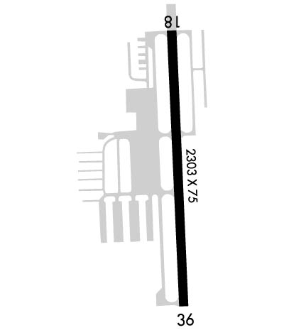
Runway Identifications
Runway Identification: 18/36
Length: 2302 ft
Width: 75 ft
Surface: ASPHALT
Edge lights: Medium Intensity

Treatment: GROOVED

 Runway: 18   Runway: 36
Mag heading: 183°Mag heading:
Rwy Slope: -.46% DownRwy Slope: .46% Up
Approach: Approach:
Pattern: Left TrafficPattern: Left Traffic
Markings: BASICMarkings: BASIC
Marking Condition: GOODMarking Condition: GOOD
Arresting Dev: Arresting Dev:
Lat & Long: N4221.1  W08327.4Lat. & Long.: N4220.7  W08327.4
Elev: 696.0 ft. MSLElev: 685.4 ft. MSL
TCH: 25 ft. AGLTCH: 29 ft. AGL
Visual Glide Path: 4.00 degreesVisual Glide Path: 3.00 degrees
Displaced Threshold: NoDisplaced Threshold: No
Touchdown Zone: YESTouchdown Zone: YES
Touchdown Elev.: 696.1 feetTouchdown Elev.: 696.1 feet
Visual Glide Slope: 2-Light PAPI on LEFT side of RunwayVisual Glide Slope: 4-Light PAPI on RIGHT side of Runway
RVR Equipment: RVR Equipment:
RVV Equipment: NORVV Equipment: NO
Approach Lights: Approach Lights:
REIL: NOREIL: NO
Centerline Lights: NOCenterline Lights: NO
Touchdown lights: NOTouchdown lights: NO
Runway Category: Runway with a Visual ApproachRunway Category: Runway with a Visual Approach
Declared Distances: Declared Distances:
Obstructions: ROADObstructions: TREE
Marked: NOT Marked/LightedMarked: NOT Marked/Lighted
Clearance slope: 7:1Clearance slope: 18:1
Obstruction height: 15 feet AGLObstruction height: 30 feet AGL
Dist. from runway: 312 feetDist. from runway: 767 feet
Centerline offset: 134 right of centerlineCenterline offset: 130 feet left of centerline
Comments: Comments:
C:1/P: