Approach Charts
| FltPlan does not have IFR approach charts available for K1C8. |
Current Weather/Notams (Metars, TAFs, Notams, NWS Forecast, PIREPS, and nearby weather)
Customs Information Send updates to Support@FltPlan.com
Customs Not Available
Database effective 05/16/2024
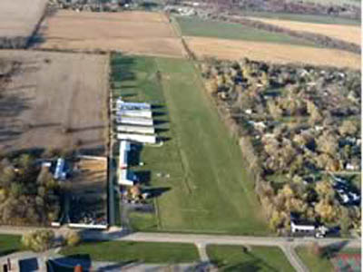
| Facility Name: | COTTONWOOD |
| City Name: | ROCKFORD |
| County: | WINNEBAGO |
| State abbrev: | IL |
| State Name: | ILLINOIS |
| | |
| Ownership: | PRIVATELY OWNED |
| Use: | OPEN TO THE PUBLIC |
| Owner's Name: | COTTONWOOD CORP |
| Address: | 5105 AUBURN ST |
| | ROCKFORD, IL 61101 |
| Owner's Phone: | 779-771-1192 |
| | |
| Manager's Name: | RON VOSS |
| Address: | 6137 GARRETT LANE #4; EMAIL ADDRESS: COTTONWOODCORP@GMAIL.COM (ALL LOWER CASE) |
| | ROCKFORD, IL 61107 |
| Phone: | 779-771-1192 |
| | |
| FAA Region: | GREAT LAKES |
| FAA Field Office: | CHI |
Runway Identifications
Runway Identification: 18/36Length: 2540 ft
Width: 260 ft
Surface: GRASS-GOOD CONDITION
Edge lights: Non-Standard Lighting SystemTreatment: NONE
| | Runway: 18 | | Runway: 36 |
| Mag heading: | N/A | Mag heading: | N/A |
| Rwy Slope: | .00% | Rwy Slope: | .00% |
| Approach: | | Approach: | |
| Pattern: | Right Traffic | Pattern: | Left Traffic |
| Markings: | NONE | Markings: | NONE |
| Marking Condition: | | Marking Condition: | |
| Arresting Dev: | | Arresting Dev: | |
| Lat & Long: | N4217.7 W08908.2 | Lat. & Long.: | N4217.3 W08908.2 |
| Elev: | 740.0 ft. MSL | Elev: | 740.0 ft. MSL |
| TCH: | | TCH: | |
| Visual Glide Path: | | Visual Glide Path: | |
| Displaced Threshold: | No | Displaced Threshold: | 400 feet; DSPLCD THLD MARKED WITH WHITE BARRELS & LGTS. |
| Touchdown Zone: | NO | Touchdown Zone: | NO |
| Touchdown Elev.: | | Touchdown Elev.: | |
| Visual Glide Slope: | | Visual Glide Slope: | |
| RVR Equipment: | | RVR Equipment: | |
| RVV Equipment: | NO | RVV Equipment: | NO |
| Approach Lights: | | Approach Lights: | |
| REIL: | NO | REIL: | NO |
| Centerline Lights: | NO | Centerline Lights: | NO |
| Touchdown lights: | NO | Touchdown lights: | NO |
| Runway Category: | Runway with a Visual Approach | Runway Category: | Runway with a Visual Approach |
| Declared Distances: | | Declared Distances: | |
| Obstructions: | | Obstructions: | ROAD |
| Marked: | | Marked: | NOT Marked/Lighted |
| Clearance slope: | 50:1 | Clearance slope: | 2:1; RWY 36 APCH RATIO 20:1 TO DTHR. |
| Obstruction height: | | Obstruction height: | 15 feet AGL |
| Dist. from runway: | | Dist. from runway: | 37 feet |
| Centerline offset: | | Centerline offset: | 130B |
| Comments: | | Comments: | |