Current Weather/Notams (Metars, TAFs, Notams, NWS Forecast, PIREPS, and nearby weather)
Customs Information Send updates to Support@FltPlan.com
Customs Not Available
Database effective 05/16/2024
Airport Diagram might not be current.
|
| Facility Name: | HOPEDALE INDUSTRIAL PARK |
| City Name: | HOPEDALE |
| County: | WORCESTER |
| State abbrev: | MA |
| State Name: | MASSACHUSETTS |
| | |
| Ownership: | PRIVATELY OWNED |
| Use: | OPEN TO THE PUBLIC |
| Owner's Name: | HOPEDALE ARPT INDUSTRIAL PARK |
| Address: | 1 AIRPORT DRIVE |
| | HOPEDALE, MA 01747 |
| Owner's Phone: | 508-478-1726 |
| | |
| Manager's Name: | JOSEPH MENFI |
| Address: | HOPEDALE INDUSTRIAL PARK |
| | HOPEDALE, MA 01747 |
| Phone: | 508-478-1726 |
| | |
| FAA Region: | NEW ENGLAND |
| FAA Field Office: | NONE |
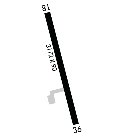
Runway Identifications
Runway Identification: 18/36Length: 3172 ft
Width: 90 ft
Surface: ASPHALT-FAIR CONDITION
Edge lights: Low IntensityTreatment: NONE
| | Runway: 18 | | Runway: 36 |
| Mag heading: | 182° | Mag heading: | 2° |
| Rwy Slope: | -.98% Down | Rwy Slope: | .98% Up |
| Approach: | | Approach: | |
| Pattern: | Left Traffic | Pattern: | Left Traffic |
| Markings: | BASIC | Markings: | BASIC |
| Marking Condition: | FAIR | Marking Condition: | FAIR |
| Arresting Dev: | | Arresting Dev: | |
| Lat & Long: | N4206.6 W07130.7 | Lat. & Long.: | N4206.1 W07130.5 |
| Elev: | 268.0 ft. MSL | Elev: | 237.0 ft. MSL |
| TCH: | | TCH: | |
| Visual Glide Path: | | Visual Glide Path: | |
| Displaced Threshold: | No | Displaced Threshold: | 110 feet; APCH RATIO 3:1 AT DTHR. |
| Touchdown Zone: | NO | Touchdown Zone: | NO |
| Touchdown Elev.: | | Touchdown Elev.: | |
| Visual Glide Slope: | | Visual Glide Slope: | |
| RVR Equipment: | | RVR Equipment: | |
| RVV Equipment: | NO | RVV Equipment: | NO |
| Approach Lights: | | Approach Lights: | |
| REIL: | NO | REIL: | NO |
| Centerline Lights: | NO | Centerline Lights: | NO |
| Touchdown lights: | NO | Touchdown lights: | NO |
| Runway Category: | Runway with a Visual Approach | Runway Category: | Runway with a Non-precision Approach |
| Declared Distances: | | Declared Distances: | |
| Obstructions: | TREES | Obstructions: | TREES |
| Marked: | NOT Marked/Lighted | Marked: | NOT Marked/Lighted |
| Clearance slope: | 4:1 | Clearance slope: | 2:1 |
| Obstruction height: | 60 feet AGL | Obstruction height: | 60 feet AGL |
| Dist. from runway: | 470 feet | Dist. from runway: | 325 feet |
| Centerline offset: | 63B | Centerline offset: | 100 feet left of centerline |
| Comments: | ROAD 30 FT N FM RWY END. | Comments: | ROAD 20 FT FM RWY END. |

