Current Weather/Notams (Metars, TAFs, Notams, NWS Forecast, PIREPS, and nearby weather)
Customs Information Send updates to Support@FltPlan.com
Customs Not Available
Database effective 05/16/2024
Airport Diagram might not be current.
|
| Facility Name: | MARTIN CAMPBELL FLD |
| City Name: | COPPERHILL |
| County: | POLK |
| State abbrev: | TN |
| State Name: | TENNESSEE |
| | |
| Ownership: | PUBLICLY OWNED |
| Use: | OPEN TO THE PUBLIC |
| Owner's Name: | POLK COUNTY |
| Address: | COUNTY COURTHOUSE |
| | BENTON, TN 37307 |
| Owner's Phone: | 423-338-4527 |
| | |
| Manager's Name: | ALAN FROSCH |
| Address: | 971 AIRPORT ROAD |
| | COPPERHILL, TN 37317 |
| Phone: | 423-496-9465 |
| | |
| FAA Region: | SOUTHERN |
| FAA Field Office: | MEM |
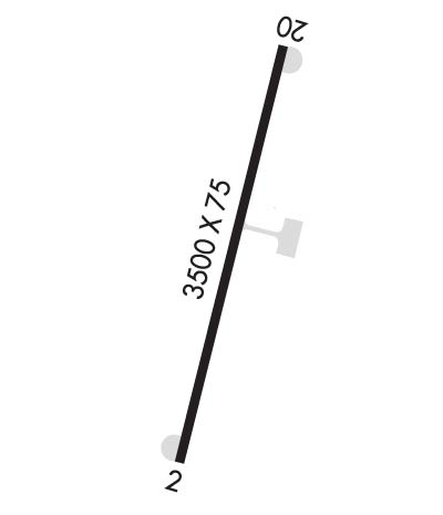
Runway Identifications
Runway Identification: 02/20Length: 3500 ft
Width: 75 ft
Surface: ASPHALT-FAIR CONDITION
Edge lights: Non-Standard Lighting SystemTreatment: NONE
| | Runway: 02 | | Runway: 20 |
| Mag heading: | 19° | Mag heading: | 199° |
| Rwy Slope: | .49% Up | Rwy Slope: | -.49% Down |
| Approach: | | Approach: | |
| Pattern: | Left Traffic | Pattern: | Right Traffic |
| Markings: | NONPRECISION INSTRUMENT | Markings: | NONPRECISION INSTRUMENT |
| Marking Condition: | FAIR | Marking Condition: | FAIR |
| Arresting Dev: | | Arresting Dev: | |
| Lat & Long: | N3500.7 W08420.9 | Lat. & Long.: | N3501.2 W08420.7 |
| Elev: | 1771.7 ft. MSL | Elev: | 1788.7 ft. MSL |
| TCH: | 45 ft. AGL | TCH: | 43 ft. AGL |
| Visual Glide Path: | 3.00 degrees | Visual Glide Path: | 4.00 degrees |
| Displaced Threshold: | 90 feet | Displaced Threshold: | 140 feet |
| Touchdown Zone: | YES | Touchdown Zone: | YES |
| Touchdown Elev.: | 1789.0 feet | Touchdown Elev.: | 1789.0 feet |
| Visual Glide Slope: | 2-Light PAPI on LEFT side of Runway | Visual Glide Slope: | 2-Light PAPI on LEFT side of Runway |
| RVR Equipment: | | RVR Equipment: | |
| RVV Equipment: | NO | RVV Equipment: | NO |
| Approach Lights: | | Approach Lights: | |
| REIL: | NO | REIL: | NO |
| Centerline Lights: | NO | Centerline Lights: | NO |
| Touchdown lights: | NO | Touchdown lights: | NO |
| Runway Category: | Runway with a Non-precision Approach | Runway Category: | Runway with a Non-precision Approach |
| Declared Distances: | TORA:3500' TODA:3500' ASDA:3360' LDA:3270' | Declared Distances: | TORA:3270' TODA:3500' ASDA:3410' LDA:3270' |
| Obstructions: | | Obstructions: | 8400 FT MTN RIDGES IN APCH; 5000 FT MTN RIDGE ALONG E SIDE OF RWY. |
| Marked: | | Marked: | NOT Marked/Lighted |
| Clearance slope: | 20:1; APCH RATIO 17:1 TO DTHR. | Clearance slope: | 20:1; APCH RATIO 19:1 TO DTHR. |
| Obstruction height: | | Obstruction height: | |
| Dist. from runway: | | Dist. from runway: | |
| Centerline offset: | | Centerline offset: | |
| Comments: | | Comments: | |

