Click here for more info on on SMS!

K18A

FRANKLIN COUNTY
CANON
GA
Time Zone: Eastern
Lat: N 3420.4
Long: W 08307.8
Elev: 890
Var: +05
Longest Runway: 5000
AWOS: 118.62
CTAF: 122.9

FBO & Flight Services info for K18A

FBOs: Update your Fuel Prices

  click here  
Franklin-Hart Airport is located 15 miles SW of Lake Hartwell 16 miles to Catachee Golf Club, 5 miles to Highland Walk Golf club, 8 miles to Emmanuel College and a pleasant drive to the Smokey Mountains. We have Jet-A & 100LL fuels that are competitively priced, an inviting lounge area complete with wifi, facilities, drinks, and snacks.
Ph: 706-245-1002 Fax: N/A Freq: 122.9Website-
                          
Service
Jet
100LL
SAF
MoGas
Full        Caution: Fuel prices have not been updated in 39 days.
Last Update: 03/11/2024 13:04

Self4.755.45    
Misc. Info: Check your Titan app for the most up to date pricing!Address: 540 AIRPORT ROAD   CANON, GA 30662

AWOSPh: 706-245-1097
-
Freq: 118.62  
If you are an FBO, call 1-203-262-1700 to update your info or email: FltPlan.Advertising@garmin.com
Advertise your FBO on FltPlan.com

Runway & Approach Info for K18A
Rwy
Length
Land Dist**
Approach*
  Rwy
Length
Land Dist**
Approach*
08
5000x75  5000'          
 
  
26
  5000x75  5000'          
 
 * only ILS, LOC, LDA, and SDF approaches to a specific runway are shown
** For any Declared Landing Distance Available, please see A/FD or Approach plates
Runway Weight Capability (lbs.) Help
Runway IDSingle WheelDouble WheelDouble Tandem WheelDual Double Wheel
08/2615,000N/AN/AN/A
These numbers are Advisory and are not limits.   The Airport Manager should have more accurate Weight Limits
Approach Charts
Approaches    
Current Weather/Notams
Customs Information Send updates to Support@FltPlan.com
Customs Not Available
Database effective 04/18/2024
Airport Diagram of K18A
Airport Diagram might not be current.

Facility Name: FRANKLIN-HART
City Name: CANON
County: FRANKLIN
State abbrev: GA
State Name: GEORGIA
   
Ownership: PUBLICLY OWNED
Use: OPEN TO THE PUBLIC
Owner's Name: FRANKLIN COUNTY; FRANKLIN-HART AIRPORT AUTHORITY.
Address: 823 AIRPORT ROAD
 CANON, GA 30520
Owner's Phone: 706-244-0383
  
Manager's Name: MARK BROWN; AIRPORT AUTHORITY.
Address: 823 AIRPORT ROAD
 CANON, GA 30520
Phone: 706-244-0383; ARPT PHONE 706-245-1002.
   
FAA Region: SOUTHERN
FAA Field Office: ATL


Sunrise / Sunset times for FRANKLIN-HART

DateSunriseSunset
04/18/24 Thursday6:5720:07
04/19/24 Friday6:5520:08
04/20/24 Saturday6:5420:09
04/21/24 Sunday6:5320:10
04/22/24 Monday6:5220:10
04/23/24 Tuesday6:5120:11
04/24/24 Wednesday6:5020:12
04/25/24 Thursday6:4820:13
04/26/24 Friday6:4720:14
04/27/24 Saturday6:4620:14
04/28/24 Sunday6:4520:15
04/29/24 Monday6:4420:16
04/30/24 Tuesday6:4320:17
05/01/24 Wednesday6:4220:17

Airport Facilities

Airport Attendance ScheduleUNATTENDED
Airport Status OPERATIONAL (This Status can change at any time - please check NOTAMS)
Airport Lighting ScheduleDUSK-0000. AFT 0000, ACTVT PAPI RWY 08 & 26; MIRL RWY 08/26 - CTAF.
Airport Storage AvailableTie Downs
Extra Services AvailableFlight Instruction
Wind IndicatorYES - (lighted)
Control TowerNO
CTAF Frequency122.900
Unicom Frequency
Rotating Beacon ColorWG
Segmented CircleYES
Landing FeeNO

Airport Inspection Data

Airport InspectedSTATE - performed by STATE AERONAUTICAL PERSONNEL
Inspection Date03/08/2024

Airport Services

Type of Fuel AvailableGrade 100LL, JET A (freeze point -40C); -10SELF SVC 100LL AND A FUEL AVBL 24 HRS WITH CREDIT CARD.
Airframe Repair ServiceNONE
Power Plant Repair ServiceNONE

Geographic Data

LatitudeN3420.4
LongitudeW08307.8 (ESTIMATED)
Arpt Elevation889ft (ESTIMATED)
Magnetic Variation05W
1 miles SWof CANON
Traffic Pattern Altitude
Sectional ChartATLANTA

Aircraft Data

Operations (Reported)YearlyAvg. Daily
General Aviation Transient 480013
General Aviation Local 400011
Air Taxi 00
Commerical 00
Commuter 00
Military 00
Aircraft based on Field
General Aviation Singles 23
General Aviation Multi 3
Jet Aircraft 0
General Aviation Helicopters 0
Military Aircraft 0
Gliders 0
Ultralights 0

FAA Services

FSS on field NO
FSS tie-in MACON
FSS Phone 1-800-WX-BRIEF
Who issues Notams MCN
Notam D service at airport YES
ARTCC Name ATLANTA

Federal Status

Airport Certification
Aircraft Rescue & Firefighting IndexNone
Airport of EntryNo
Custom Landing RightsNo
Joint Civil/MilitaryNo
Military Landing rightsYES

Federal Agreements

NATIONAL PLAN OF INTEGRATED AIRPORT SYSTEMS (NPIAS)
ASSURANCES PURSUANT TO TITLE VI, CIVIL RIGHTS ACT OF 1964
GRANT AGREEMENT HAS EXPIRED; HOWEVER, AGREEMENT REMAINS IN EFFECT FOR THIS FACILITY AS LONG AS IT IS PUBLIC USE.

Remarks

FOR CD CTC ATLANTA ARTCC AT 770-210-7692.
Airport Communications & Frequencies:
CTAF Frequency:
122.900
Remarks
  • APCH/DEP SVC PRVDD BY ATLANTA ARTCC ON FREQS 127.5/316.05 (ATHENS RCAG).
  • Runway Identifications
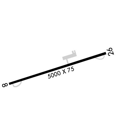
    Runway Identification: 08/26
    Length: 5000 ft
    Width: 75 ft
    Surface: ASPHALT-GOOD CONDITION
    Edge lights: Medium Intensity

    Treatment: NONE

     Runway: 08   Runway: 26
    Mag heading: 77°Mag heading: 257°
    Rwy Slope: 1.23% UpRwy Slope: -1.23% Down
    Approach: Approach:
    Pattern: Left TrafficPattern: Left Traffic
    Markings: NONPRECISION INSTRUMENTMarkings: NONPRECISION INSTRUMENT
    Marking Condition: FAIRMarking Condition: FAIR
    Arresting Dev: Arresting Dev:
    Lat & Long: N3420.3  W08308.3Lat. & Long.: N3420.5  W08307.4
    Elev: 828.5 ft. MSLElev: 889.9 ft. MSL
    TCH: 23 ft. AGLTCH: 23 ft. AGL
    Visual Glide Path: 3.00 degreesVisual Glide Path: 3.00 degrees
    Displaced Threshold: NoDisplaced Threshold: No
    Touchdown Zone: YESTouchdown Zone: YES
    Touchdown Elev.: 851.9 feetTouchdown Elev.: 889.9 feet
    Visual Glide Slope: 2-Light PAPI on LEFT side of RunwayVisual Glide Slope: 2-Light PAPI on LEFT side of Runway
    RVR Equipment: RVR Equipment:
    RVV Equipment: NORVV Equipment: NO
    Approach Lights: Approach Lights:
    REIL: NOREIL: NO
    Centerline Lights: NOCenterline Lights: NO
    Touchdown lights: NOTouchdown lights: NO
    Runway Category: Runway with a Non-precision Approach having visibility minimums greater than 3/4 mileRunway Category: Runway with a Non-precision Approach having visibility minimums greater than 3/4 mile
    Declared Distances: Declared Distances:
    Obstructions: TREESObstructions: TREES
    Marked: NOT Marked/LightedMarked: NOT Marked/Lighted
    Clearance slope: 9:1Clearance slope: 19:1
    Obstruction height: 42 feet AGLObstruction height: 84 feet AGL
    Dist. from runway: 578 feetDist. from runway: 1796 feet
    Centerline offset: 294 left of centerlineCenterline offset: 351 feet left of centerline
    Comments: Comments:
    C:2/P: