Current Weather/Notams (Metars, TAFs, Notams, NWS Forecast, PIREPS, and nearby weather)
Customs Information Send updates to Support@FltPlan.com
Customs Not Available
Database effective 05/16/2024
Airport Diagram might not be current.
|
| Facility Name: | CROSS KEYS |
| City Name: | CROSS KEYS |
| County: | GLOUCESTER |
| State abbrev: | NJ |
| State Name: | NEW JERSEY |
| | |
| Ownership: | PRIVATELY OWNED |
| Use: | OPEN TO THE PUBLIC |
| Owner's Name: | CROSS KEYS AIRPORT INC |
| Address: | 1531 N. TUCKAHOE ROAD |
| | WILLIAMSTOWN, NJ 08094 |
| Owner's Phone: | 856-629-3033 |
| | |
| Manager's Name: | HARRY STRAHLENDORF |
| Address: | 1531 N. TUCKAHOE ROAD |
| | WILLIAMSTOWN, NJ 08094 |
| Phone: | 856-629-3033 |
| | |
| FAA Region: | EASTERN |
| FAA Field Office: | HAR |
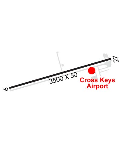
Runway Identifications
Runway Identification: 09/27Length: 3500 ft
Width: 50 ft
Surface: ASPHALT-GOOD CONDITION
Edge lights: Non-Standard Lighting SystemTreatment: NONE
| | Runway: 09 | | Runway: 27 |
| Mag heading: | 84° | Mag heading: | 264° |
| Rwy Slope: | .69% Up | Rwy Slope: | -.69% Down |
| Approach: | | Approach: | |
| Pattern: | Right Traffic | Pattern: | Left Traffic |
| Markings: | NONPRECISION INSTRUMENT | Markings: | BASIC |
| Marking Condition: | FAIR | Marking Condition: | FAIR |
| Arresting Dev: | | Arresting Dev: | |
| Lat & Long: | N3942.2 W07502.3 | Lat. & Long.: | N3942.4 W07501.6 |
| Elev: | 137.0 ft. MSL | Elev: | 161.0 ft. MSL |
| TCH: | | TCH: | |
| Visual Glide Path: | | Visual Glide Path: | |
| Displaced Threshold: | No | Displaced Threshold: | 200 feet; DSPLCD THLD MARKED WITH LGTS. |
| Touchdown Zone: | YES | Touchdown Zone: | YES |
| Touchdown Elev.: | 162.0 feet | Touchdown Elev.: | 162.0 feet |
| Visual Glide Slope: | | Visual Glide Slope: | |
| RVR Equipment: | | RVR Equipment: | |
| RVV Equipment: | NO | RVV Equipment: | NO |
| Approach Lights: | | Approach Lights: | |
| REIL: | NO | REIL: | NO |
| Centerline Lights: | NO | Centerline Lights: | NO |
| Touchdown lights: | NO | Touchdown lights: | NO |
| Runway Category: | Runway with a Non-precision Approach | Runway Category: | Runway with a Visual Approach |
| Declared Distances: | | Declared Distances: | |
| Obstructions: | TREES | Obstructions: | TREE; ROAD, FENCE, BLDGS, & TREES NEAR APCH END. |
| Marked: | NOT Marked/Lighted | Marked: | NOT Marked/Lighted |
| Clearance slope: | 7:1 | Clearance slope: | 5:1 |
| Obstruction height: | 90 feet AGL | Obstruction height: | 73 feet AGL |
| Dist. from runway: | 900 feet | Dist. from runway: | 570 feet |
| Centerline offset: | 250 left of centerline; TREES ARE 125' R & L OF CNTRL EXTNDD. | Centerline offset: | 135 feet right of centerline |
| Comments: | +20 FT TREES 50 FT RT & LFT OF EXTD CTLN 0-200 FT FM APP END. +60 FT TREES 200 FT RT & LFT OF EXTD CTLN AT APP END. | Comments: | |