Click here for more info on on SMS!

K17K

BOISE CITY
BOISE CITY
OK
Time Zone: Central
Lat: N 3646.5
Long: W 10230.6
Elev: 4174
Var: -09
Longest Runway: 4211
CTAF: 122.9

FBO & Flight Services info for K17K

FBOs: Update your Fuel Prices

BOISE CITY ARPTPh: 580-544-3122
-
Freq: 122.9
Service
Jet
100LL
SAF
MoGas
Fuel Avail: NO FUEL AVAILABLE
Full        Last Update: 04/16/2024 05:50:17

Self        
If you are an FBO, call 1-203-262-1700 to update your info or email: FltPlan.Advertising@garmin.com
Advertise your FBO on FltPlan.com

Runway & Approach Info for K17K
Rwy
Length
Land Dist**
Approach*
  Rwy
Length
Land Dist**
Approach*
04
4211x60  4211'          
 
  
22
  4211x60  4211'          
 
 * only ILS, LOC, LDA, and SDF approaches to a specific runway are shown
** For any Declared Landing Distance Available, please see A/FD or Approach plates
Runway Weight Capability (lbs.) Help
Runway IDSingle WheelDouble WheelDouble Tandem WheelDual Double Wheel
04/224,000N/AN/AN/A
These numbers are Advisory and are not limits.   The Airport Manager should have more accurate Weight Limits
Approach Charts
Approaches    
Current Weather/Notams
Customs Information Send updates to Support@FltPlan.com
Customs Not Available
Database effective 04/18/2024
Airport Diagram of K17K
Airport Diagram might not be current.

Facility Name: BOISE CITY
City Name: BOISE CITY
County: CIMARRON
State abbrev: OK
State Name: OKLAHOMA
   
Ownership: PUBLICLY OWNED
Use: OPEN TO THE PUBLIC
Owner's Name: CITY OF BOISE CITY
Address: P.O. BOX 129, 23 N. LOGAN
 BOISE CITY, OK 73933
Owner's Phone: 580-544-2271
  
Manager's Name: WAYNE TWYMAN
Address: CITY HALL, P.O. BOX 129
 BOISE CITY, OK 73933
Phone: 580-544-2271
   
FAA Region: SOUTHWEST
FAA Field Office: AOK


Sunrise / Sunset times for BOISE CITY

DateSunriseSunset
04/15/24 Monday7:1520:25
04/16/24 Tuesday7:1420:26
04/17/24 Wednesday7:1220:27
04/18/24 Thursday7:1120:28
04/19/24 Friday7:1020:29
04/20/24 Saturday7:0820:30
04/21/24 Sunday7:0720:31
04/22/24 Monday7:0620:31
04/23/24 Tuesday7:0520:32
04/24/24 Wednesday7:0320:33
04/25/24 Thursday7:0220:34
04/26/24 Friday7:0120:35
04/27/24 Saturday7:0020:36
04/28/24 Sunday6:5920:37

Airport Facilities

Airport Attendance ScheduleUNATTENDED
Airport Status OPERATIONAL (This Status can change at any time - please check NOTAMS)
Airport Lighting ScheduleACTVT PAPI RWY 04 & 22 - CTAF. MIRL RWY 04/22 SS-SR; PRESET LOW INTST; INCR INTST - CTAF.
Airport Storage AvailableTie Downs
Extra Services AvailableCrop Dusting
Wind IndicatorYES - (lighted)
Control TowerNO
CTAF Frequency122.900
Unicom Frequency
Rotating Beacon ColorWG
Segmented CircleYES
Landing FeeNO

Airport Inspection Data

Airport InspectedSTATE - performed by STATE AERONAUTICAL PERSONNEL
Inspection Date10/25/2022

Airport Services

Type of Fuel AvailableNone
Airframe Repair ServiceNONE
Power Plant Repair ServiceNONE

Geographic Data

LatitudeN3646.5
LongitudeW10230.6 (ESTIMATED)
Arpt Elevation4174ft (SURVEYED)
Magnetic Variation09E
3 miles Nof BOISE CITY
Traffic Pattern Altitude
Sectional ChartWICHITA

Aircraft Data

Operations (Reported)YearlyAvg. Daily
General Aviation Transient 10003
General Aviation Local 25007
Air Taxi 00
Commerical 00
Commuter 00
Military 00
Aircraft based on Field
General Aviation Singles 9
General Aviation Multi 1
Jet Aircraft 0
General Aviation Helicopters 0
Military Aircraft 0
Gliders 0
Ultralights 0

FAA Services

FSS on field NO
FSS tie-in MC ALESTER
FSS Phone 1-800-WX-BRIEF
Who issues Notams MLC
Notam D service at airport YES
ARTCC Name ALBUQUERQUE

Federal Status

Airport Certification
Aircraft Rescue & Firefighting IndexNone
Airport of EntryNo
Custom Landing RightsNo
Joint Civil/MilitaryNo
Military Landing rightsYES

Federal Agreements

NATIONAL PLAN OF INTEGRATED AIRPORT SYSTEMS (NPIAS)
GRANT AGREEMENTS UNDER FAAP/ADAP/AIP
ASSURANCES PURSUANT TO TITLE VI, CIVIL RIGHTS ACT OF 1964

Remarks

FOR CD CTC ALBUQUERQUE ARTCC AT 505-856-4861.
Airport Communications & Frequencies:
CTAF Frequency:
122.900
Remarks
  • APCH/DEP SVC PRVDD BY ALBUQUERQUE ARTCC (ABQ) ON FREQS 127.85/285.475 (MOUNT DORA RCAG).
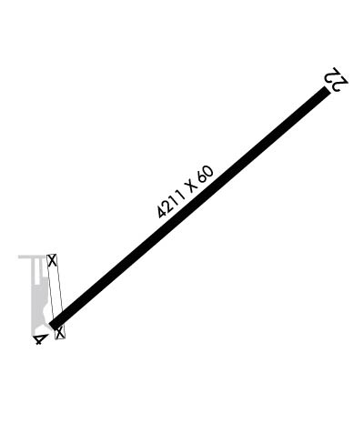
  • Runway Identifications
    Runway Identification: 04/22
    Length: 4211 ft
    Width: 60 ft
    Surface: ASPHALT
    Edge lights: Medium Intensity

    Treatment: NONE

     Runway: 04   Runway: 22
    Mag heading: 40°Mag heading: 220°
    Rwy Slope: -.18% DownRwy Slope: .18% Up
    Approach: Approach:
    Pattern: Left TrafficPattern: Left Traffic
    Markings: NONPRECISION INSTRUMENTMarkings: NONPRECISION INSTRUMENT
    Marking Condition: GOODMarking Condition: GOOD
    Arresting Dev: Arresting Dev:
    Lat & Long: N3646.2  W10231.0Lat. & Long.: N3646.7  W10230.3
    Elev: 4171.7 ft. MSLElev: 4164.3 ft. MSL
    TCH: 42 ft. AGLTCH: 42 ft. AGL
    Visual Glide Path: 3.00 degreesVisual Glide Path: 3.00 degrees
    Displaced Threshold: NoDisplaced Threshold: No
    Touchdown Zone: YESTouchdown Zone: YES
    Touchdown Elev.: 4174.3 feetTouchdown Elev.: 4172.1 feet
    Visual Glide Slope: 4-Light PAPI on LEFT side of Runway; PAPI UNUSBL BYD 5 DEGS LEFT OF CNTRLN.Visual Glide Slope: 4-Light PAPI on LEFT side of Runway
    RVR Equipment: RVR Equipment:
    RVV Equipment: NORVV Equipment: NO
    Approach Lights: Approach Lights:
    REIL: NOREIL: NO
    Centerline Lights: NOCenterline Lights: NO
    Touchdown lights: NOTouchdown lights: NO
    Runway Category: Runway with a Non-precision ApproachRunway Category: Runway with a Visual Approach
    Declared Distances: Declared Distances:
    Obstructions: TREES; 20 FT TREELINE CROSSES RWY 04 APCH.Obstructions: ROAD
    Marked: NOT Marked/LightedMarked: NOT Marked/Lighted
    Clearance slope: 1:1Clearance slope: 16:1
    Obstruction height: 21 feet AGLObstruction height: 15 feet AGL
    Dist. from runway: 227 feetDist. from runway: 450 feet
    Centerline offset: 212 right of centerlineCenterline offset: B
    Comments: 20 FT TREES 190 FT FM THR 240 FT R OF CNTRLN.Comments:
    C:/P: