Current Weather/Notams (Metars, TAFs, Notams, NWS Forecast, PIREPS, and nearby weather)
Customs Information Send updates to Support@FltPlan.com
Customs Not Available
Database effective 04/18/2024
Airport Diagram might not be current.
|
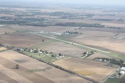
| Facility Name: | PORT BUCYRUS/CRAWFORD COUNTY |
| City Name: | BUCYRUS |
| County: | CRAWFORD |
| State abbrev: | OH |
| State Name: | OHIO |
| | |
| Ownership: | PUBLICLY OWNED |
| Use: | OPEN TO THE PUBLIC |
| Owner's Name: | CITY OF BUCYRUS |
| Address: | PO BOX 1244 |
| | BUCYRUS, OH 44820-4244 |
| Owner's Phone: | 419-562-6767 |
| | |
| Manager's Name: | KEVIN DETRAY; KNDETRAY@GMAIL.COM. |
| Address: | 2254 ISAAC BEAL RD |
| | BUCYRUS, OH 44820-9692 |
| Phone: | 419-562-7596 |
| | |
| FAA Region: | GREAT LAKES |
| FAA Field Office: | DET |
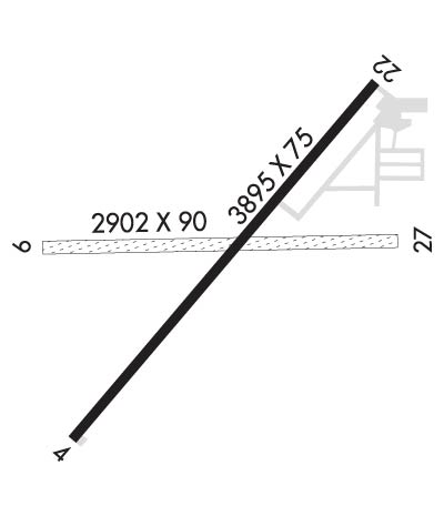
Runway Identifications
Runway Identification: 04/22Length: 3895 ft
Width: 75 ft
Surface: ASPHALT
Edge lights: Medium IntensityTreatment: NONE
| | Runway: 04 | | Runway: 22 |
| Mag heading: | 43° | Mag heading: | 223° |
| Rwy Slope: | -.02% Down | Rwy Slope: | .02% Up |
| Approach: | | Approach: | |
| Pattern: | Left Traffic | Pattern: | Left Traffic |
| Markings: | NONPRECISION INSTRUMENT | Markings: | NONPRECISION INSTRUMENT |
| Marking Condition: | FAIR | Marking Condition: | FAIR |
| Arresting Dev: | | Arresting Dev: | |
| Lat & Long: | N4046.6 W08258.7 | Lat. & Long.: | N4047.1 W08258.2 |
| Elev: | 1000.1 ft. MSL | Elev: | 999.4 ft. MSL |
| TCH: | 44 ft. AGL | TCH: | 26 ft. AGL |
| Visual Glide Path: | 3.50 degrees | Visual Glide Path: | 3.00 degrees |
| Displaced Threshold: | 276 feet | Displaced Threshold: | No |
| Touchdown Zone: | YES | Touchdown Zone: | YES |
| Touchdown Elev.: | 1002.6 feet | Touchdown Elev.: | 1002.6 feet |
| Visual Glide Slope: | 2-Light PAPI on LEFT side of Runway | Visual Glide Slope: | 4-Light PAPI on LEFT side of Runway |
| RVR Equipment: | | RVR Equipment: | |
| RVV Equipment: | NO | RVV Equipment: | NO |
| Approach Lights: | | Approach Lights: | |
| REIL: | YES | REIL: | YES |
| Centerline Lights: | NO | Centerline Lights: | NO |
| Touchdown lights: | NO | Touchdown lights: | NO |
| Runway Category: | Runway with a Non-precision Approach | Runway Category: | Runway with a Non-precision Approach |
| Declared Distances: | | Declared Distances: | |
| Obstructions: | TREE | Obstructions: | ROAD |
| Marked: | NOT Marked/Lighted | Marked: | NOT Marked/Lighted |
| Clearance slope: | 5:1; OBSTN CLNC SLP 13:1 TO DTHR. | Clearance slope: | 13:1 |
| Obstruction height: | 60 feet AGL | Obstruction height: | 15 feet AGL |
| Dist. from runway: | 535 feet | Dist. from runway: | 395 feet |
| Centerline offset: | 300 right of centerline | Centerline offset: | 274 feet left of centerline |
| Comments: | | Comments: | |
Runway Identification: 09/27Length: 2902 ft
Width: 90 ft
Surface: GRASS-GOOD CONDITION
Edge lights: Treatment: NONE
| | Runway: 09 | | Runway: 27 |
| Mag heading: | 93° | Mag heading: | 273° |
| Rwy Slope: | .40% Up | Rwy Slope: | -.40% Down |
| Approach: | | Approach: | |
| Pattern: | Left Traffic | Pattern: | Left Traffic |
| Markings: | NONE | Markings: | NONE |
| Marking Condition: | | Marking Condition: | |
| Arresting Dev: | | Arresting Dev: | |
| Lat & Long: | N4046.9 W08258.8 | Lat. & Long.: | N4046.9 W08258.2 |
| Elev: | 996.1 ft. MSL | Elev: | 1007.8 ft. MSL |
| TCH: | | TCH: | |
| Visual Glide Path: | | Visual Glide Path: | |
| Displaced Threshold: | No | Displaced Threshold: | No |
| Touchdown Zone: | YES | Touchdown Zone: | YES |
| Touchdown Elev.: | 1007.8 feet | Touchdown Elev.: | 1007.8 feet |
| Visual Glide Slope: | | Visual Glide Slope: | |
| RVR Equipment: | | RVR Equipment: | |
| RVV Equipment: | NO | RVV Equipment: | NO |
| Approach Lights: | | Approach Lights: | |
| REIL: | NO | REIL: | NO |
| Centerline Lights: | NO | Centerline Lights: | NO |
| Touchdown lights: | NO | Touchdown lights: | NO |
| Runway Category: | Runway with a Visual Approach | Runway Category: | Runway with a Visual Approach |
| Declared Distances: | | Declared Distances: | |
| Obstructions: | TREE | Obstructions: | TREE |
| Marked: | NOT Marked/Lighted | Marked: | NOT Marked/Lighted |
| Clearance slope: | 4:1 | Clearance slope: | 4:1 |
| Obstruction height: | 70 feet AGL | Obstruction height: | 65 feet AGL |
| Dist. from runway: | 325 feet | Dist. from runway: | 265 feet |
| Centerline offset: | 75 right of centerline | Centerline offset: | 175 feet left of centerline |
| Comments: | | Comments: | |