Click here for more info on on SMS!

K16G

SENECA COUNTY
TIFFIN
OH
Time Zone: Eastern
Lat: N 4105.6
Long: W 08312.8
Elev: 786
Var: +05
Longest Runway: 4000
AWOS: 127.17
CTAF: 123.0

FBO & Flight Services info for K16G

FBOs: Update your Fuel Prices
Tiffin Aire, Inc. located at K16G is your premier full service FBO in NW Ohio. We specialize in aircraft sales & service, propeller/governor sales & service, de-ice boot sales & service, aircraft charter & rental. Also available are: heated hangars, flight planning, crew lounge, conference room, courtesy vehicles, shower room, coffee, & ice. We look forward to your visit.
Ph: 419-447-4263
-
Freq: 123.0WebsiteE-Mail
                   
Service
Jet
100LL
SAF
MoGas
Fuel Avail: Service during business hours. Credit Card payment at pump after hours.
Full5.105.41    Last Update: 04/21/2024 10:16

Self5.105.41    
Misc. Info: Address: 1778 WEST US HIGHWAY 224   TIFFIN, OH 44883

AWOSPh: 419-443-1043
-
Freq: 127.17  
If you are an FBO, call 1-203-262-1700 to update your info or email: FltPlan.Advertising@garmin.com
Advertise your FBO on FltPlan.com

Runway & Approach Info for K16G
Rwy
Length
Land Dist**
Approach*
  Rwy
Length
Land Dist**
Approach*
06
4000x75  4000'          
 
  
24
  4000x75  4000'          
 
 * only ILS, LOC, LDA, and SDF approaches to a specific runway are shown
** For any Declared Landing Distance Available, please see A/FD or Approach plates
Runway Weight Capability (lbs.) Help
Runway IDSingle WheelDouble WheelDouble Tandem WheelDual Double Wheel
06/24N/AN/AN/AN/A
These numbers are Advisory and are not limits.   The Airport Manager should have more accurate Weight Limits
Approach Charts
Approaches    
Current Weather/Notams
Customs Information Send updates to Support@FltPlan.com
Customs Not Available
Database effective 05/16/2024
Airport Diagram of K16G
Airport Diagram might not be current.

Facility Name: SENECA COUNTY
City Name: TIFFIN
County: SENECA
State abbrev: OH
State Name: OHIO
   
Ownership: PUBLICLY OWNED
Use: OPEN TO THE PUBLIC
Owner's Name: SENECA COUNTY COMMISSIONERS
Address: 81 JEFFERSON ST
 TIFFIN, OH 44883
Owner's Phone: 419-447-4550
  
Manager's Name: ANDREW NEWMAN
Address: 1778 W US HIGHWAY 224
 TIFFIN, OH 44883-8820
Phone: 419-447-4263
   
FAA Region: GREAT LAKES
FAA Field Office: DET
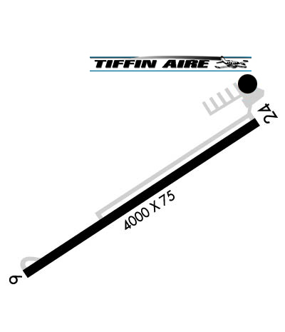

Sunrise / Sunset times for SENECA COUNTY

DateSunriseSunset
04/25/24 Thursday6:3820:24
04/26/24 Friday6:3620:25
04/27/24 Saturday6:3520:26
04/28/24 Sunday6:3420:27
04/29/24 Monday6:3220:29
04/30/24 Tuesday6:3120:30
05/01/24 Wednesday6:3020:31
05/02/24 Thursday6:2820:32
05/03/24 Friday6:2720:33
05/04/24 Saturday6:2620:34
05/05/24 Sunday6:2520:35
05/06/24 Monday6:2420:36
05/07/24 Tuesday6:2220:37
05/08/24 Wednesday6:2120:38

Airport Facilities

Airport Attendance Schedule7 Days A Week 0800-DUSK; UNATNDD MAJOR HOLS.
Airport Status OPERATIONAL (This Status can change at any time - please check NOTAMS)
Airport Lighting ScheduleACTVT REIL RWY 06 & 24; PAPI RWY 06 & 24; MIRL RWY 06/24 - CTAF.
Airport Storage AvailableTie Downs, Hanger
Extra Services AvailableCharter, Flight Instruction, Aircraft Rental, Aircraft Sales
Wind IndicatorYES - (lighted)
Control TowerNO
CTAF Frequency123.000
Unicom Frequency123.000
Rotating Beacon ColorWG
Segmented CircleNO
Landing FeeNO

Airport Inspection Data

Airport InspectedSTATE - performed by STATE AERONAUTICAL PERSONNEL
Inspection Date10/01/2021

Airport Services

Type of Fuel AvailableGrade 100LL, JET A; -10100LL & JET A+ AVBL AFT HRS & HOLS SELF SVC VIA CREDIT CARD.
Airframe Repair ServiceMAJOR
Power Plant Repair ServiceMAJOR

Geographic Data

LatitudeN4105.6
LongitudeW08312.8 (ESTIMATED)
Arpt Elevation785ft (SURVEYED)
Magnetic Variation05W
2 miles SWof TIFFIN
Traffic Pattern Altitude
Sectional ChartDETROIT

Aircraft Data

Operations (Reported)YearlyAvg. Daily
General Aviation Transient 1400038
General Aviation Local 41000112
Air Taxi 500014
Commerical 00
Commuter 00
Military 1650
Aircraft based on Field
General Aviation Singles 22
General Aviation Multi 10
Jet Aircraft 1
General Aviation Helicopters 0
Military Aircraft 0
Gliders 0
Ultralights 0

FAA Services

FSS on field NO
FSS tie-in CLEVELAND
FSS Phone 1-800-WX-BRIEF
Who issues Notams CLE
Notam D service at airport YES
ARTCC Name CLEVELAND

Federal Status

Airport Certification
Aircraft Rescue & Firefighting IndexNone
Airport of EntryNo
Custom Landing RightsNo
Joint Civil/MilitaryNo
Military Landing rightsNo

Federal Agreements

NATIONAL PLAN OF INTEGRATED AIRPORT SYSTEMS (NPIAS)

Remarks

THIS AIRPORT HAS BEEN SURVEYED BY THE NATIONAL GEODETIC SURVEY.
FOR CD CTC TOLEDO APCH AT 419-865-1495.
Airport Communications & Frequencies:
CTAF Frequency:
123.000
Unicom Frequency:
123.000
TOLEDO Primary Approach Frequencies:  
120.8
317.55
TOLEDO Primary Departure Frequencies:  
120.8
317.55
Runway Identifications
Runway Identification: 06/24
Length: 4000 ft
Width: 75 ft
Surface: ASPHALT-GOOD CONDITION
Edge lights: Medium Intensity

Treatment: NONE

 Runway: 06   Runway: 24
Mag heading: 61°Mag heading: 241°
Rwy Slope: -.12% DownRwy Slope: .12% Up
Approach: Approach:
Pattern: Left TrafficPattern: Left Traffic
Markings: NONPRECISION INSTRUMENTMarkings: NONPRECISION INSTRUMENT
Marking Condition: GOODMarking Condition: GOOD
Arresting Dev: Arresting Dev:
Lat & Long: N4105.5  W08313.1Lat. & Long.: N4105.8  W08312.4
Elev: 785.9 ft. MSLElev: 781.1 ft. MSL
TCH: 38 ft. AGLTCH: 38 ft. AGL
Visual Glide Path: 3.00 degreesVisual Glide Path: 3.00 degrees
Displaced Threshold: NoDisplaced Threshold: No
Touchdown Zone: YESTouchdown Zone: YES
Touchdown Elev.: 785.9 feetTouchdown Elev.: 784.7 feet
Visual Glide Slope: 4-Light PAPI on LEFT side of Runway; PAPI UNUSBL BYD 5 DEGS LEFT OF CNTRLN.Visual Glide Slope: 4-Light PAPI on LEFT side of Runway; PAPI UNUSBL BYD 4 DEGS LEFT & 8 DEGS RIGHT OF CNTRLN
RVR Equipment: RVR Equipment:
RVV Equipment: NORVV Equipment: NO
Approach Lights: Approach Lights:
REIL: YESREIL: YES
Centerline Lights: NOCenterline Lights: NO
Touchdown lights: NOTouchdown lights: NO
Runway Category: Runway with a Non-precision ApproachRunway Category: Runway with a Non-precision Approach
Declared Distances: Declared Distances:
Obstructions: Obstructions: TREES
Marked: Marked: NOT Marked/Lighted
Clearance slope: 20:1Clearance slope: 5:1
Obstruction height: Obstruction height: 80 feet AGL
Dist. from runway: Dist. from runway: 611 feet
Centerline offset: Centerline offset: 297 feet left of centerline
Comments: Comments:
C:2/P: