Current Weather/Notams (Metars, TAFs, Notams, NWS Forecast, PIREPS, and nearby weather)
Customs Information Send updates to Support@FltPlan.com
Customs Not Available
Database effective 05/16/2024
Airport Diagram might not be current.
|
| Facility Name: | COOK COUNTY |
| City Name: | ADEL |
| County: | COOK |
| State abbrev: | GA |
| State Name: | GEORGIA |
| | |
| Ownership: | PUBLICLY OWNED |
| Use: | OPEN TO THE PUBLIC |
| Owner's Name: | COOK COUNTY |
| Address: | 1200 SO. HUTCHISON |
| | ADEL, GA 31620 |
| Owner's Phone: | 229-896-2266 |
| | |
| Manager's Name: | JERRY CONNELL |
| Address: | 160 AIRPORT RD. |
| | ADEL, GA 31620 |
| Phone: | (229) 507-1340 |
| | |
| FAA Region: | SOUTHERN |
| FAA Field Office: | ATL |
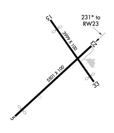
Runway Identifications
Runway Identification: 05/23Length: 5501 ft
Width: 100 ft
Surface: ASPHALT-GOOD CONDITION
Edge lights: Medium IntensityTreatment: NONE
| | Runway: 05 | | Runway: 23 |
| Mag heading: | 51° | Mag heading: | 231° |
| Rwy Slope: | .03% Up | Rwy Slope: | -.03% Down |
| Approach: | | Approach: | |
| Pattern: | Left Traffic | Pattern: | Left Traffic |
| Markings: | NONPRECISION INSTRUMENT | Markings: | NONPRECISION INSTRUMENT |
| Marking Condition: | GOOD | Marking Condition: | GOOD |
| Arresting Dev: | | Arresting Dev: | |
| Lat & Long: | N3107.8 W08327.7 | Lat. & Long.: | N3108.4 W08326.9 |
| Elev: | 232.9 ft. MSL | Elev: | 234.7 ft. MSL |
| TCH: | 45 ft. AGL | TCH: | 40 ft. AGL |
| Visual Glide Path: | 3.00 degrees | Visual Glide Path: | 3.00 degrees |
| Displaced Threshold: | 500 feet | Displaced Threshold: | No |
| Touchdown Zone: | YES | Touchdown Zone: | YES |
| Touchdown Elev.: | 235.2 feet | Touchdown Elev.: | 235.2 feet |
| Visual Glide Slope: | 2-Light PAPI on LEFT side of Runway | Visual Glide Slope: | 2-Light PAPI on LEFT side of Runway |
| RVR Equipment: | | RVR Equipment: | |
| RVV Equipment: | NO | RVV Equipment: | NO |
| Approach Lights: | | Approach Lights: | |
| REIL: | NO | REIL: | NO |
| Centerline Lights: | NO | Centerline Lights: | NO |
| Touchdown lights: | NO | Touchdown lights: | NO |
| Runway Category: | Runway with a Non-precision Approach having visibility minimums greater than 3/4 mile | Runway Category: | Runway with a Non-precision Approach having visibility minimums greater than 3/4 mile |
| Declared Distances: | TORA:5501' TODA:5501' ASDA:5501' LDA:5000' | Declared Distances: | TORA:5501' TODA:5501' ASDA:5501' LDA:5501' |
| Obstructions: | OTHER; PLOWED FLD 224 FT FROM EOR. 12 FT FARM EQPT POSS. | Obstructions: | ROAD |
| Marked: | NOT Marked/Lighted | Marked: | NOT Marked/Lighted |
| Clearance slope: | 2:1 | Clearance slope: | 10:1 |
| Obstruction height: | 12 feet AGL | Obstruction height: | 15 feet AGL |
| Dist. from runway: | 224 feet | Dist. from runway: | 350 feet |
| Centerline offset: | | Centerline offset: | 262 feet right of centerline |
| Comments: | | Comments: | |
Runway Identification: 15/33Length: 3999 ft
Width: 100 ft
Surface: ASPHALT-GOOD CONDITION
Edge lights: Treatment: NONE
| | Runway: 15 | | Runway: 33 |
| Mag heading: | 149° | Mag heading: | 329° |
| Rwy Slope: | -.01% Down | Rwy Slope: | .01% Up |
| Approach: | | Approach: | |
| Pattern: | Left Traffic | Pattern: | Left Traffic |
| Markings: | BASIC | Markings: | BASIC |
| Marking Condition: | GOOD | Marking Condition: | GOOD |
| Arresting Dev: | | Arresting Dev: | |
| Lat & Long: | N3108.6 W08327.4 | Lat. & Long.: | N3108.1 W08326.9 |
| Elev: | 234.7 ft. MSL | Elev: | 234.5 ft. MSL |
| TCH: | | TCH: | |
| Visual Glide Path: | | Visual Glide Path: | |
| Displaced Threshold: | 599 feet | Displaced Threshold: | 349 feet |
| Touchdown Zone: | YES | Touchdown Zone: | YES |
| Touchdown Elev.: | 235.1 feet | Touchdown Elev.: | 235.1 feet |
| Visual Glide Slope: | | Visual Glide Slope: | |
| RVR Equipment: | | RVR Equipment: | |
| RVV Equipment: | NO | RVV Equipment: | NO |
| Approach Lights: | | Approach Lights: | |
| REIL: | NO | REIL: | NO |
| Centerline Lights: | NO | Centerline Lights: | NO |
| Touchdown lights: | NO | Touchdown lights: | NO |
| Runway Category: | Runway with a Visual Approach | Runway Category: | Runway with a Visual Approach |
| Declared Distances: | TORA:3999' TODA:3999' ASDA:3859' LDA:3259' | Declared Distances: | TORA:3999' TODA:3999' ASDA:3999' LDA:3650' |
| Obstructions: | ROAD | Obstructions: | ROAD |
| Marked: | NOT Marked/Lighted | Marked: | NOT Marked/Lighted |
| Clearance slope: | 13:1; RWY 15 APCH RATIO 20:1 TO DSPLCD THR. | Clearance slope: | 4:1; RWY 33 APCH RATIO 12:1 TO DSPLCD THR. |
| Obstruction height: | 15 feet AGL | Obstruction height: | 15 feet AGL |
| Dist. from runway: | 400 feet | Dist. from runway: | 260 feet |
| Centerline offset: | 140 right of centerline | Centerline offset: | |
| Comments: | | Comments: | |

