Current Weather/Notams (Metars, TAFs, Notams, NWS Forecast, PIREPS, and nearby weather)
Customs Information Send updates to Support@FltPlan.com
Customs Not Available
Database effective 05/16/2024
Airport Diagram might not be current.
|
| Facility Name: | FREMONT |
| City Name: | FREMONT |
| County: | SANDUSKY |
| State abbrev: | OH |
| State Name: | OHIO |
| | |
| Ownership: | PRIVATELY OWNED |
| Use: | OPEN TO THE PUBLIC |
| Owner's Name: | FREMONT AIRPORT LLC |
| Address: | 365 S SR53 |
| | FREMONT, OH 43420 |
| Owner's Phone: | 419-332-8037 |
| | |
| Manager's Name: | REX DAMSCHRODER |
| Address: | 365 S SR53 |
| | FREMONT, OH 43420 |
| Phone: | (419) 307-3111 |
| | |
| FAA Region: | GREAT LAKES |
| FAA Field Office: | DET |
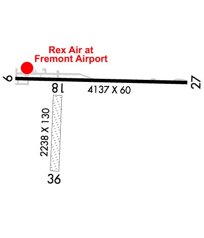
Runway Identifications
Runway Identification: 09/27Length: 4137 ft
Width: 60 ft
Surface: ASPHALT-FAIR CONDITION
Edge lights: Low IntensityTreatment: NONE
| | Runway: 09 | | Runway: 27 |
| Mag heading: | 95° | Mag heading: | 275° |
| Rwy Slope: | .20% Up | Rwy Slope: | -.20% Down |
| Approach: | | Approach: | |
| Pattern: | Left Traffic | Pattern: | Left Traffic |
| Markings: | NONSTANDARD | Markings: | NONSTANDARD |
| Marking Condition: | FAIR | Marking Condition: | FAIR; NSTD MKGS, WHITE LINES MARK RWY ENDS. DTHRS NOT MKD. |
| Arresting Dev: | | Arresting Dev: | |
| Lat & Long: | N4120.1 W08310.0 | Lat. & Long.: | N4120.1 W08309.1 |
| Elev: | 652.2 ft. MSL | Elev: | 660.3 ft. MSL |
| TCH: | | TCH: | |
| Visual Glide Path: | | Visual Glide Path: | |
| Displaced Threshold: | 126 feet | Displaced Threshold: | No |
| Touchdown Zone: | YES | Touchdown Zone: | YES |
| Touchdown Elev.: | 662.9 feet | Touchdown Elev.: | 663.2 feet |
| Visual Glide Slope: | | Visual Glide Slope: | |
| RVR Equipment: | | RVR Equipment: | |
| RVV Equipment: | NO | RVV Equipment: | NO |
| Approach Lights: | | Approach Lights: | |
| REIL: | NO | REIL: | NO |
| Centerline Lights: | NO | Centerline Lights: | NO |
| Touchdown lights: | NO | Touchdown lights: | NO |
| Runway Category: | Runway with a Non-precision Approach | Runway Category: | Runway with a Visual Approach |
| Declared Distances: | | Declared Distances: | |
| Obstructions: | ROAD | Obstructions: | TREES |
| Marked: | NOT Marked/Lighted | Marked: | NOT Marked/Lighted |
| Clearance slope: | 1:1 | Clearance slope: | 3:1 |
| Obstruction height: | 16 feet AGL | Obstruction height: | 65 feet AGL |
| Dist. from runway: | 223 feet | Dist. from runway: | 400 feet |
| Centerline offset: | 125 right of centerline | Centerline offset: | 50 feet right of centerline |
| Comments: | 16 FT ROAD, 120 FT DIST, 250 FT L/R; 10 FT SIGNS, 110 FT DIST, 130 FT R. | Comments: | 15 FT DROP OFF EAST END. EAST 330 FT RWY 27 UNUSBL. |
Runway Identification: 18/36Length: 2238 ft
Width: 130 ft
Surface: GRASS-GOOD CONDITION
Edge lights: Treatment: NONE
| | Runway: 18 | | Runway: 36 |
| Mag heading: | 186° | Mag heading: | 6° |
| Rwy Slope: | .12% Up | Rwy Slope: | -.12% Down |
| Approach: | | Approach: | |
| Pattern: | Left Traffic | Pattern: | Left Traffic |
| Markings: | | Markings: | |
| Marking Condition: | | Marking Condition: | |
| Arresting Dev: | | Arresting Dev: | |
| Lat & Long: | N4120.0 W08309.8 | Lat. & Long.: | N4119.7 W08309.8 |
| Elev: | 654.2 ft. MSL | Elev: | 656.9 ft. MSL |
| TCH: | | TCH: | |
| Visual Glide Path: | | Visual Glide Path: | |
| Displaced Threshold: | No | Displaced Threshold: | No |
| Touchdown Zone: | NO | Touchdown Zone: | NO |
| Touchdown Elev.: | | Touchdown Elev.: | |
| Visual Glide Slope: | | Visual Glide Slope: | |
| RVR Equipment: | | RVR Equipment: | |
| RVV Equipment: | NO | RVV Equipment: | NO |
| Approach Lights: | | Approach Lights: | |
| REIL: | NO | REIL: | NO |
| Centerline Lights: | NO | Centerline Lights: | NO |
| Touchdown lights: | NO | Touchdown lights: | NO |
| Runway Category: | Runway with a Visual Approach | Runway Category: | Runway with a Visual Approach |
| Declared Distances: | | Declared Distances: | |
| Obstructions: | TREES | Obstructions: | TREE |
| Marked: | NOT Marked/Lighted | Marked: | NOT Marked/Lighted |
| Clearance slope: | 2:1 | Clearance slope: | |
| Obstruction height: | 90 feet AGL | Obstruction height: | 60 feet AGL |
| Dist. from runway: | 262 feet | Dist. from runway: | 0 feet |
| Centerline offset: | 94 left of centerline | Centerline offset: | 125 feet right of centerline |
| Comments: | | Comments: | |