Current Weather/Notams (Metars, TAFs, Notams, NWS Forecast, PIREPS, and nearby weather)
Customs Information Send updates to Support@FltPlan.com
Customs Not Available
Database effective 05/16/2024
Airport Diagram might not be current.
|
| Facility Name: | LT WILLIAM M MILLIKEN |
| City Name: | EUREKA |
| County: | GREENWOOD |
| State abbrev: | KS |
| State Name: | KANSAS |
| | |
| Ownership: | PUBLICLY OWNED |
| Use: | OPEN TO THE PUBLIC |
| Owner's Name: | CITY OF EUREKA |
| Address: | MEMORIAL HALL |
| | EUREKA, KS 67045 |
| Owner's Phone: | 620-583-6511 |
| | |
| Manager's Name: | |
| Address: | |
| | |
| Phone: | |
| | |
| FAA Region: | CENTRAL |
| FAA Field Office: | NONE |
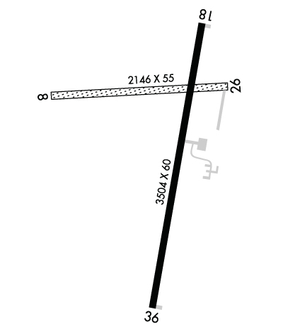
Runway Identifications
Runway Identification: 08/26Length: 2143 ft
Width: 55 ft
Surface: GRASS
Edge lights: Treatment: NONE
| | Runway: 08 | | Runway: 26 |
| Mag heading: | 85° | Mag heading: | 265° |
| Rwy Slope: | .63% Up | Rwy Slope: | -.63% Down |
| Approach: | | Approach: | |
| Pattern: | Left Traffic | Pattern: | Left Traffic |
| Markings: | NONSTANDARD | Markings: | NONSTANDARD |
| Marking Condition: | FAIR; WHITE TIRES MARK RY END. | Marking Condition: | FAIR; WHITE TIRES MARK RY END. |
| Arresting Dev: | | Arresting Dev: | |
| Lat & Long: | N3751.2 W09617.8 | Lat. & Long.: | N3751.2 W09617.4 |
| Elev: | 1194.6 ft. MSL | Elev: | 1208.1 ft. MSL |
| TCH: | | TCH: | |
| Visual Glide Path: | | Visual Glide Path: | |
| Displaced Threshold: | No | Displaced Threshold: | No |
| Touchdown Zone: | YES | Touchdown Zone: | YES |
| Touchdown Elev.: | 1208.1 feet | Touchdown Elev.: | 1208.1 feet |
| Visual Glide Slope: | | Visual Glide Slope: | |
| RVR Equipment: | | RVR Equipment: | |
| RVV Equipment: | NO | RVV Equipment: | NO |
| Approach Lights: | | Approach Lights: | |
| REIL: | NO | REIL: | NO |
| Centerline Lights: | NO | Centerline Lights: | NO |
| Touchdown lights: | NO | Touchdown lights: | NO |
| Runway Category: | Runway with a Visual Approach | Runway Category: | Runway with a Visual Approach |
| Declared Distances: | | Declared Distances: | |
| Obstructions: | FENCE; PLINE AND POLES EXCEED RWY 26 APCH AND DEP SFCS. EXER CTN. | Obstructions: | |
| Marked: | MARKED; DELINEATED WITH WHITE PAINTED TIRES. | Marked: | |
| Clearance slope: | CONTROLLING OBSTN EXCEEDS A 45 DEG SLP. | Clearance slope: | 20:1 |
| Obstruction height: | 4 feet AGL | Obstruction height: | |
| Dist. from runway: | 0 feet | Dist. from runway: | |
| Centerline offset: | | Centerline offset: | |
| Comments: | | Comments: | |
Runway Identification: 18/36Length: 3504 ft
Width: 60 ft
Surface: ASPHALT-GOOD CONDITION
Edge lights: Medium IntensityTreatment: NONE
Weight: PCN 3 /F/C/Y/U
| | Runway: 18 | | Runway: 36 |
| Mag heading: | 189° | Mag heading: | 9° |
| Rwy Slope: | -.31% Down | Rwy Slope: | .31% Up |
| Approach: | | Approach: | |
| Pattern: | Left Traffic | Pattern: | Left Traffic |
| Markings: | NONPRECISION INSTRUMENT | Markings: | NUMBERS ONLY |
| Marking Condition: | GOOD | Marking Condition: | GOOD |
| Arresting Dev: | | Arresting Dev: | |
| Lat & Long: | N3751.3 W09617.4 | Lat. & Long.: | N3750.8 W09617.6 |
| Elev: | 1206.4 ft. MSL | Elev: | 1195.6 ft. MSL |
| TCH: | 34 ft. AGL | TCH: | 40 ft. AGL |
| Visual Glide Path: | 3.00 degrees | Visual Glide Path: | 3.00 degrees |
| Displaced Threshold: | No | Displaced Threshold: | No |
| Touchdown Zone: | YES | Touchdown Zone: | YES |
| Touchdown Elev.: | 1207.0 feet | Touchdown Elev.: | 1207.0 feet |
| Visual Glide Slope: | 2-Light PAPI on LEFT side of Runway | Visual Glide Slope: | 2-Light PAPI on LEFT side of Runway |
| RVR Equipment: | | RVR Equipment: | |
| RVV Equipment: | NO | RVV Equipment: | NO |
| Approach Lights: | | Approach Lights: | |
| REIL: | NO | REIL: | NO |
| Centerline Lights: | NO | Centerline Lights: | NO |
| Touchdown lights: | NO | Touchdown lights: | NO |
| Runway Category: | Runway with a Non-precision Approach | Runway Category: | Runway with a Visual Approach |
| Declared Distances: | | Declared Distances: | |
| Comments: | | Comments: | GROUND DROPS DOWN ABRUPTLY 85 FT FM END OF RY. |
