Click here for more info on on SMS!

K12S

MONUMENT MUNI
MONUMENT
OR
Time Zone: Pacific
Lat: N 4449.9
Long: W 11925.8
Elev: 2323
Var: -18
Longest Runway: 2104
CTAF: 122.9

FBO & Flight Services info for K12S

FBOs: Update your Fuel Prices

AIRPORTPh: 541-934-2025
-
Freq: 122.9
RUNWAY - GRAVEL
-
-
 
If you are an FBO, call 1-203-262-1700 to update your info or email: FltPlan.Advertising@garmin.com
Advertise your FBO on FltPlan.com

Runway & Approach Info for K12S
Rwy
Length
Land Dist**
Approach*
  Rwy
Length
Land Dist**
Approach*
14
2104x29  2104'          
 
  
32
  2104x29  2104'          
 
 * only ILS, LOC, LDA, and SDF approaches to a specific runway are shown
** For any Declared Landing Distance Available, please see A/FD or Approach plates
Runway Weight Capability (lbs.) Help
Runway IDSingle WheelDouble WheelDouble Tandem WheelDual Double Wheel
14/32N/AN/AN/AN/A
These numbers are Advisory and are not limits.   The Airport Manager should have more accurate Weight Limits
Approach Charts
FltPlan does not have IFR approach charts available for K12S.
Current Weather/Notams
Customs Information Send updates to Support@FltPlan.com
Customs Not Available
Database effective 05/16/2024
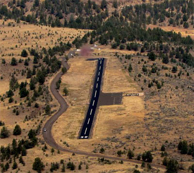
Facility Name: MONUMENT MUNI
City Name: MONUMENT
County: GRANT
State abbrev: OR
State Name: OREGON
   
Ownership: PUBLICLY OWNED
Use: OPEN TO THE PUBLIC
Owner's Name: CITY OF MONUMENT
Address: PO BOX 426
 MONUMENT, OR 97864
Owner's Phone: 541-934-2025
  
Manager's Name: DOROTHY JORDAN
Address: PO BOX 426
 MONUMENT, OR 97864
Phone: 541-934-2025
   
FAA Region: NORTHWEST MOUNTAIN
FAA Field Office: SEA
Resurfaced & painted runway at 12S, 09/2015.


Click here for full scale & interactive Sectional view of K12S


Sunrise / Sunset times for MONUMENT MUNI

DateSunriseSunset
04/25/24 Thursday5:5519:57
04/26/24 Friday5:5419:58
04/27/24 Saturday5:5219:59
04/28/24 Sunday5:5120:00
04/29/24 Monday5:4920:02
04/30/24 Tuesday5:4820:03
05/01/24 Wednesday5:4620:04
05/02/24 Thursday5:4520:05
05/03/24 Friday5:4320:06
05/04/24 Saturday5:4220:08
05/05/24 Sunday5:4120:09
05/06/24 Monday5:3920:10
05/07/24 Tuesday5:3820:11
05/08/24 Wednesday5:3720:12

Airport Facilities

Airport Attendance ScheduleUNATTENDED
Airport Status OPERATIONAL (This Status can change at any time - please check NOTAMS)
Airport Lighting Schedule
Airport Storage AvailableTie Downs
Extra Services AvailableNONE
Wind IndicatorYES - (unlit)
Control TowerNO
CTAF Frequency122.900
Unicom FrequencyFREQ 122.900
Rotating Beacon Color
Segmented CircleNO; TIRES PAINTED WHITE.
Landing FeeNO

Airport Inspection Data

Airport InspectedSTATE - performed by STATE AERONAUTICAL PERSONNEL
Inspection Date05/19/2022

Airport Services

Type of Fuel AvailableNone
Airframe Repair ServiceNONE
Power Plant Repair ServiceNONE

Geographic Data

LatitudeN4449.9
LongitudeW11925.8 (ESTIMATED)
Arpt Elevation2323ft (SURVEYED)
Magnetic Variation18E
1 miles NWof MONUMENT
Traffic Pattern Altitude
Sectional ChartSEATTLE

Aircraft Data

Operations (Reported)YearlyAvg. Daily
General Aviation Transient 1300
General Aviation Local 00
Air Taxi 00
Commerical 00
Commuter 00
Military 00
Aircraft based on Field
General Aviation Singles 0
General Aviation Multi 0
Jet Aircraft 0
General Aviation Helicopters 0
Military Aircraft 0
Gliders 0
Ultralights 0

FAA Services

FSS on field NO
FSS tie-in MC MINNVILLE
FSS Phone 1-800-WX-BRIEF
Who issues Notams MMV
Notam D service at airport YES
ARTCC Name SEATTLE

Federal Status

Airport Certification
Aircraft Rescue & Firefighting IndexNone
Airport of EntryNo
Custom Landing RightsNo
Joint Civil/MilitaryNo
Military Landing rightsNo

Remarks

INTMTLY CLSD WINTERS DUE TO SNOW.
RY 32 TERRAIN SLOPES UP 3.7%.
HAS +15 FT BY 25 FT CONCRETE PAD AT NORTH END RY 14/32.
WILDLIFE ON AND INVOF ARPT.
FOR CD CTC SEATTLE ARTCC AT 253-351-3694.
Runway Identifications
Runway Identification: 14/32
Length: 2104 ft
Width: 29 ft
Surface: ASPHALT-FAIR CONDITION
Edge lights:

Treatment: NONE

 Runway: 14   Runway: 32
Mag heading: 139°Mag heading: 319°
Rwy Slope: -3.23% DownRwy Slope: 3.23% Up
Approach: Approach:
Pattern: Left TrafficPattern: Left Traffic
Markings: Markings:
Marking Condition: RY ENDS MKD AT EACH CORNER BY A SINGLE WHITE TIRE.Marking Condition:
Arresting Dev: Arresting Dev:
Lat & Long: N4450.1  W11925.9Lat. & Long.: N4449.7  W11925.7
Elev: 2323.0 ft. MSLElev: 2255.0 ft. MSL
TCH: TCH:
Visual Glide Path: Visual Glide Path:
Displaced Threshold: NoDisplaced Threshold: No
Touchdown Zone: NOTouchdown Zone: NO
Touchdown Elev.: Touchdown Elev.:
Visual Glide Slope: Visual Glide Slope:
RVR Equipment: RVR Equipment:
RVV Equipment: NORVV Equipment: NO
Approach Lights: Approach Lights:
REIL: NOREIL: NO
Centerline Lights: NOCenterline Lights: NO
Touchdown lights: NOTouchdown lights: NO
Runway Category: Runway with a Visual ApproachRunway Category: Runway with a Visual Approach
Declared Distances: Declared Distances:
Obstructions: HILLObstructions:
Marked: NOT Marked/LightedMarked:
Clearance slope: 5:1Clearance slope: 50:1
Obstruction height: 15 feet AGLObstruction height:
Dist. from runway: 280 feetDist. from runway:
Centerline offset: 100 right of centerlineCenterline offset:
Comments: RW 14- 12' TREE AT 96' FROM RUNWAY END AND 15' RIGHT OF CENTERLINE RW 14- 4' FENCE AT 96' FROM RUNWAY END BOTH SIDES OF CENETR LINEComments: 7 FT TREES AT 30 FT FM RWY END & 30-50 FT L & R OF CNTRLN.
C:/P: