Current Weather/Notams (Metars, TAFs, Notams, NWS Forecast, PIREPS, and nearby weather)
Customs Information Send updates to Support@FltPlan.com
Customs Not Available
Database effective 05/16/2024
Airport Diagram might not be current.
|
| Facility Name: | BREWTON MUNI |
| City Name: | BREWTON |
| County: | ESCAMBIA |
| State abbrev: | AL |
| State Name: | ALABAMA |
| | |
| Ownership: | PUBLICLY OWNED |
| Use: | OPEN TO THE PUBLIC |
| Owner's Name: | CITY OF BREWTON |
| Address: | PO BOX 368 |
| | BREWTON, AL 36427 |
| Owner's Phone: | 251-867-3281 |
| | |
| Manager's Name: | EARL LAMBERT |
| Address: | 111 DOGWOOD LANE W. |
| | BREWTON, AL 36426 |
| Phone: | 251-363-1551 |
| | |
| FAA Region: | SOUTHERN |
| FAA Field Office: | JAN |
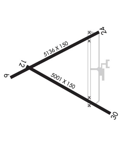
Runway Identifications
Runway Identification: 06/24Length: 5136 ft
Width: 150 ft
Surface: ASPHALT-FAIR CONDITION
Edge lights: Treatment: NONE
| | Runway: 06 | | Runway: 24 |
| Mag heading: | 64° | Mag heading: | 244° |
| Rwy Slope: | .05% Up | Rwy Slope: | -.05% Down |
| Approach: | | Approach: | |
| Pattern: | Left Traffic | Pattern: | Left Traffic |
| Markings: | NONPRECISION INSTRUMENT | Markings: | NONPRECISION INSTRUMENT |
| Marking Condition: | FAIR; MARKINGS FADED, CNTLN OBSCURED. | Marking Condition: | FAIR; MARKINGS FADED, CNTLN OBSCURED. |
| Arresting Dev: | | Arresting Dev: | |
| Lat & Long: | N3103.0 W08704.5 | Lat. & Long.: | N3103.4 W08703.7 |
| Elev: | 80.9 ft. MSL | Elev: | 83.3 ft. MSL |
| TCH: | | TCH: | |
| Visual Glide Path: | | Visual Glide Path: | |
| Displaced Threshold: | No | Displaced Threshold: | No |
| Touchdown Zone: | YES | Touchdown Zone: | YES |
| Touchdown Elev.: | 82.6 feet | Touchdown Elev.: | 83.3 feet |
| Visual Glide Slope: | | Visual Glide Slope: | |
| RVR Equipment: | | RVR Equipment: | |
| RVV Equipment: | NO | RVV Equipment: | NO |
| Approach Lights: | | Approach Lights: | |
| REIL: | NO | REIL: | NO |
| Centerline Lights: | NO | Centerline Lights: | NO |
| Touchdown lights: | NO | Touchdown lights: | NO |
| Runway Category: | Runway with a Non-precision Approach having visibility minimums greater than 3/4 mile | Runway Category: | Runway with a Non-precision Approach having visibility minimums greater than 3/4 mile |
| Declared Distances: | | Declared Distances: | |
| Obstructions: | TREE | Obstructions: | TREES |
| Marked: | NOT Marked/Lighted | Marked: | NOT Marked/Lighted |
| Clearance slope: | 5:1 | Clearance slope: | 6:1 |
| Obstruction height: | 56 feet AGL | Obstruction height: | 69 feet AGL |
| Dist. from runway: | 511 feet | Dist. from runway: | 621 feet |
| Centerline offset: | 286 left of centerline | Centerline offset: | 287 feet left of centerline |
| Comments: | | Comments: | |
Runway Identification: 12/30Length: 5001 ft
Width: 150 ft
Surface: ASPHALT-POOR CONDITION
Edge lights: Medium IntensityTreatment: NONE
| | Runway: 12 | | Runway: 30 |
| Mag heading: | 121° | Mag heading: | 301° |
| Rwy Slope: | .33% Up | Rwy Slope: | -.33% Down |
| Approach: | | Approach: | |
| Pattern: | Left Traffic | Pattern: | Left Traffic |
| Markings: | NONPRECISION INSTRUMENT | Markings: | NONPRECISION INSTRUMENT |
| Marking Condition: | FAIR; MARKINGS FADED, CNTLN OBSCURED. | Marking Condition: | FAIR; MARKINGS FADED, CNTLN OBSCURED. |
| Arresting Dev: | | Arresting Dev: | |
| Lat & Long: | N3103.1 W08704.4 | Lat. & Long.: | N3102.7 W08703.5 |
| Elev: | 82.1 ft. MSL | Elev: | 98.8 ft. MSL |
| TCH: | 48 ft. AGL | TCH: | 42 ft. AGL |
| Visual Glide Path: | 3.25 degrees | Visual Glide Path: | 3.50 degrees |
| Displaced Threshold: | No | Displaced Threshold: | No |
| Touchdown Zone: | YES | Touchdown Zone: | YES |
| Touchdown Elev.: | 90.5 feet | Touchdown Elev.: | 98.8 feet |
| Visual Glide Slope: | 2-Light PAPI on LEFT side of Runway; UNUSBL BYD 6 DEG LEFT OF CNTRLN. | Visual Glide Slope: | 2-Light PAPI on LEFT side of Runway |
| RVR Equipment: | | RVR Equipment: | |
| RVV Equipment: | NO | RVV Equipment: | NO |
| Approach Lights: | | Approach Lights: | |
| REIL: | NO | REIL: | NO |
| Centerline Lights: | NO | Centerline Lights: | NO |
| Touchdown lights: | NO | Touchdown lights: | NO |
| Runway Category: | Runway with a Non-precision Approach having visibility minimums greater than 3/4 mile | Runway Category: | Runway with a Non-precision Approach having visibility minimums greater than 3/4 mile |
| Declared Distances: | | Declared Distances: | |
| Obstructions: | TREES | Obstructions: | TREE |
| Marked: | NOT Marked/Lighted | Marked: | NOT Marked/Lighted |
| Clearance slope: | 19:1 | Clearance slope: | 18:1 |
| Obstruction height: | 90 feet AGL | Obstruction height: | 96 feet AGL |
| Dist. from runway: | 1980 feet | Dist. from runway: | 2009 feet |
| Centerline offset: | 269 left of centerline | Centerline offset: | 356 feet left of centerline |
| Comments: | | Comments: | BRUSH LCTD 79 FT FM RWY END, 91 FT LEFT OF CNTLN. |

