Current Weather/Notams (Metars, TAFs, Notams, NWS Forecast, PIREPS, and nearby weather)
Customs Information Send updates to Support@FltPlan.com
Customs Not Available
Database effective 05/16/2024
Airport Diagram might not be current.
|
| Facility Name: | SHELBY COMMUNITY |
| City Name: | SHELBY |
| County: | RICHLAND |
| State abbrev: | OH |
| State Name: | OHIO |
| | |
| Ownership: | PRIVATELY OWNED |
| Use: | OPEN TO THE PUBLIC |
| Owner's Name: | SHELBY AIRPORT LLC |
| Address: | PO BOX 29 |
| | SHELBY, OH 44875-0029 |
| Owner's Phone: | 419-347-1185 |
| | |
| Manager's Name: | DOUG SCHMIDT |
| Address: | 5085 STATE ROUTE 39 W |
| | SHELBY, OH 44875-9061 |
| Phone: | 419-347-1185; HOME 419-347-8543. |
| | |
| FAA Region: | GREAT LAKES |
| FAA Field Office: | DET |
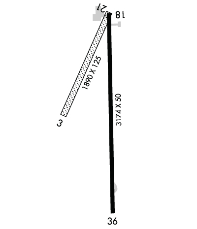
Runway Identifications
Runway Identification: 03/21Length: 1890 ft
Width: 125 ft
Surface: GRASS-GOOD CONDITION
Edge lights: Treatment: NONE
| | Runway: 03 | | Runway: 21 |
| Mag heading: | 31° | Mag heading: | 211° |
| Rwy Slope: | -.11% Down | Rwy Slope: | .11% Up |
| Approach: | | Approach: | |
| Pattern: | Left Traffic | Pattern: | Left Traffic |
| Markings: | NONE | Markings: | NONE |
| Marking Condition: | | Marking Condition: | |
| Arresting Dev: | | Arresting Dev: | |
| Lat & Long: | N4052.3 W08242.0 | Lat. & Long.: | N4052.6 W08241.8 |
| Elev: | 1120.4 ft. MSL | Elev: | 1118.3 ft. MSL |
| TCH: | | TCH: | |
| Visual Glide Path: | | Visual Glide Path: | |
| Displaced Threshold: | No | Displaced Threshold: | No |
| Touchdown Zone: | YES | Touchdown Zone: | YES |
| Touchdown Elev.: | 1120.4 feet | Touchdown Elev.: | 1120.4 feet |
| Visual Glide Slope: | | Visual Glide Slope: | |
| RVR Equipment: | | RVR Equipment: | |
| RVV Equipment: | NO | RVV Equipment: | NO |
| Approach Lights: | | Approach Lights: | |
| REIL: | NO | REIL: | NO |
| Centerline Lights: | NO | Centerline Lights: | NO |
| Touchdown lights: | NO | Touchdown lights: | NO |
| Runway Category: | Runway with a Visual Approach | Runway Category: | Runway with a Visual Approach |
| Declared Distances: | | Declared Distances: | |
| Obstructions: | TREE | Obstructions: | BLDG |
| Marked: | NOT Marked/Lighted | Marked: | NOT Marked/Lighted |
| Clearance slope: | 4:1 | Clearance slope: | 10:1 |
| Obstruction height: | 75 feet AGL | Obstruction height: | 42 feet AGL |
| Dist. from runway: | 345 feet | Dist. from runway: | 427 feet |
| Centerline offset: | 70 left of centerline | Centerline offset: | 68 feet left of centerline |
| Comments: | | Comments: | |
Runway Identification: 18/36Length: 3174 ft
Width: 50 ft
Surface: ASPHALT-FAIR CONDITION
Edge lights: Non-Standard Lighting SystemTreatment: NONE
| | Runway: 18 | | Runway: 36 |
| Mag heading: | 185° | Mag heading: | 5° |
| Rwy Slope: | .06% Up | Rwy Slope: | -.06% Down |
| Approach: | | Approach: | |
| Pattern: | Left Traffic | Pattern: | Left Traffic |
| Markings: | BASIC | Markings: | BASIC |
| Marking Condition: | GOOD | Marking Condition: | GOOD |
| Arresting Dev: | | Arresting Dev: | |
| Lat & Long: | N4052.6 W08241.8 | Lat. & Long.: | N4052.1 W08241.8 |
| Elev: | 1117.5 ft. MSL | Elev: | 1119.4 ft. MSL |
| TCH: | | TCH: | |
| Visual Glide Path: | | Visual Glide Path: | |
| Displaced Threshold: | No | Displaced Threshold: | No |
| Touchdown Zone: | YES | Touchdown Zone: | YES |
| Touchdown Elev.: | 1119.1 feet | Touchdown Elev.: | 1119.5 feet |
| Visual Glide Slope: | | Visual Glide Slope: | |
| RVR Equipment: | | RVR Equipment: | |
| RVV Equipment: | NO | RVV Equipment: | NO |
| Approach Lights: | | Approach Lights: | |
| REIL: | NO | REIL: | NO |
| Centerline Lights: | NO | Centerline Lights: | NO |
| Touchdown lights: | NO | Touchdown lights: | NO |
| Runway Category: | Runway with a Visual Approach | Runway Category: | Runway with a Visual Approach |
| Declared Distances: | | Declared Distances: | |
| Obstructions: | ROAD | Obstructions: | PLINE |
| Marked: | NOT Marked/Lighted | Marked: | NOT Marked/Lighted |
| Clearance slope: | | Clearance slope: | 17:1 |
| Obstruction height: | 15 feet AGL | Obstruction height: | 94 feet AGL |
| Dist. from runway: | 201 feet | Dist. from runway: | 1810 feet |
| Centerline offset: | | Centerline offset: | 289 feet left of centerline |
| Comments: | ROAD 165'FM RWY END 125'R. | Comments: | SEASONAL CROPS 75 FT L/R, UP TO 10 FT. |

