Click here for more info on on SMS!

K11R

BRENHAM MUNI
BRENHAM
TX
Time Zone: Central
Lat: N 3013.2
Long: W 09622.5
Elev: 318
Var: -06
Longest Runway: 6003
AWOS: 121.12
CTAF: 123.07

FBO & Flight Services info for K11R

FBOs: Update your Fuel Prices

  click here  
Started in 2009 in Brenham, Texas as a maintenance shop. We newly opened FBO services in Jan, 2020. Currently we are on the South End of the field. Come in and visit us!
Ph: 979-830-1361
-
Freq: 123.07WebsiteE-Mail
                     
Service
Jet
100LL
SAF
MoGas
Fuel Avail: Hours of Operation: 0800 - 7 Days after hour call out fee.
Full        Last Update: 04/12/2024 11:05

Self4.994.62    
Misc. Info: Address: 2901 AVIATION WAY   BRENHAM, TX 77833

AWOSPh: 979-836-2303
-
Freq: 121.12  
If you are an FBO, call 1-203-262-1700 to update your info or email: FltPlan.Advertising@garmin.com
Advertise your FBO on FltPlan.com

Runway & Approach Info for K11R
Rwy
Length
Land Dist**
Approach*
  Rwy
Length
Land Dist**
Approach*
16
6003x75  6003'          
 
  
34
  6003x75  6003'          
 
 * only ILS, LOC, LDA, and SDF approaches to a specific runway are shown
** For any Declared Landing Distance Available, please see A/FD or Approach plates
Runway Weight Capability (lbs.) Help
Runway IDSingle WheelDouble WheelDouble Tandem WheelDual Double Wheel
16/3430,000N/AN/AN/A
These numbers are Advisory and are not limits.   The Airport Manager should have more accurate Weight Limits
Approach Charts
Approaches    
Current Weather/Notams
Customs Information Send updates to Support@FltPlan.com
Customs Not Available
Database effective 05/16/2024
Airport Diagram of K11R
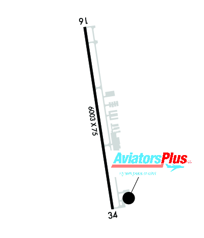
Airport Diagram might not be current.

Facility Name: BRENHAM MUNI
City Name: BRENHAM
County: WASHINGTON
State abbrev: TX
State Name: TEXAS
   
Ownership: PUBLICLY OWNED
Use: OPEN TO THE PUBLIC
Owner's Name: CITY OF BRENHAM
Address: PO BOX 1059
 BRENHAM, TX 77834
Owner's Phone: 979-337-7232
  
Manager's Name: JIM HALLEY
Address: 3001 AVIATION WAY
 BRENHAM, TX 77833
Phone: 979-337-7232
   
FAA Region: SOUTHWEST
FAA Field Office: TEX


Sunrise / Sunset times for BRENHAM MUNI

DateSunriseSunset
04/22/24 Monday6:5019:58
04/23/24 Tuesday6:4919:59
04/24/24 Wednesday6:4819:59
04/25/24 Thursday6:4720:00
04/26/24 Friday6:4620:01
04/27/24 Saturday6:4520:01
04/28/24 Sunday6:4420:02
04/29/24 Monday6:4320:02
04/30/24 Tuesday6:4320:03
05/01/24 Wednesday6:4220:04
05/02/24 Thursday6:4120:04
05/03/24 Friday6:4020:05
05/04/24 Saturday6:3920:06
05/05/24 Sunday6:3820:06

Airport Facilities

Airport Attendance ScheduleMON - FRI 0800-1700
Airport Status OPERATIONAL (This Status can change at any time - please check NOTAMS)
Airport Lighting ScheduleACTVT MIRL RWY 16/34 - CTAF.
Airport Storage AvailableTie Downs
Extra Services AvailableCharter, Aircraft Rental
Wind IndicatorYES - (lighted)
Control TowerNO
CTAF Frequency123.075
Unicom Frequency123.075
Rotating Beacon ColorWG
Segmented CircleYES
Landing FeeNO

Airport Inspection Data

Airport InspectedSTATE - performed by PRIVATE CONTRACT PERSONNEL
Inspection Date05/21/2023

Airport Services

Type of Fuel AvailableGrade 100LL, JET A (freeze point -40C); -10FUEL 24 HR SELF-SVC. FULL SVC AVBL DURG ATNDD HRS. FOR AFT HRS SVC 979-830-1361.
Airframe Repair ServiceMAJOR
Power Plant Repair ServiceMAJOR

Geographic Data

LatitudeN3013.2
LongitudeW09622.5 (ESTIMATED)
Arpt Elevation317ft (ESTIMATED)
Magnetic Variation06E
3 miles NEof BRENHAM
Traffic Pattern Altitude
Sectional ChartHOUSTON

Aircraft Data

Operations (Reported)YearlyAvg. Daily
General Aviation Transient 690019
General Aviation Local 2070057
Air Taxi 00
Commerical 00
Commuter 00
Military 500
Aircraft based on Field
General Aviation Singles 44
General Aviation Multi 4
Jet Aircraft 11
General Aviation Helicopters 0
Military Aircraft 0
Gliders 0
Ultralights 0

FAA Services

FSS on field NO
FSS tie-in MONTGOMERY COUNTY
FSS Phone 1-800-WX-BRIEF
Who issues Notams 11R
Notam D service at airport YES
ARTCC Name HOUSTON

Federal Status

Airport Certification
Aircraft Rescue & Firefighting IndexNone
Airport of EntryNo
Custom Landing RightsNo
Joint Civil/MilitaryNo
Military Landing rightsYES

Federal Agreements

NATIONAL PLAN OF INTEGRATED AIRPORT SYSTEMS (NPIAS)
GRANT AGREEMENTS UNDER FAAP/ADAP/AIP
ASSURANCES PURSUANT TO TITLE VI, CIVIL RIGHTS ACT OF 1964

Remarks

FOR CD CTC HOUSTON APCH AT 281-443-5844 TO CNL IFR CALL 281-443-5888.
94 FT LGTD RADAR ANT, 1060 FT WEST OF RWY 16 END.
Airport Communications & Frequencies:
CTAF Frequency:
123.075
Unicom Frequency:
123.075
HOUSTON Primary Approach Frequencies:  
134.3
360.85
HOUSTON Primary Departure Frequencies:  
134.3
360.85
Runway Identifications
Runway Identification: 16/34
Length: 6003 ft
Width: 75 ft
Surface: ASPHALT-FAIR CONDITION
Edge lights: Medium Intensity

Treatment: NONE

 Runway: 16   Runway: 34
Mag heading: 165°Mag heading: 345°
Rwy Slope: -1.12% DownRwy Slope: 1.12% Up
Approach: Approach:
Pattern: Left TrafficPattern: Left Traffic
Markings: NONPRECISION INSTRUMENTMarkings: NONPRECISION INSTRUMENT
Marking Condition: FAIRMarking Condition: FAIR
Arresting Dev: Arresting Dev:
Lat & Long: N3013.7  W09622.6Lat. & Long.: N3012.7  W09622.4
Elev: 317.7 ft. MSLElev: 250.4 ft. MSL
TCH: 36 ft. AGLTCH: 48 ft. AGL
Visual Glide Path: 3.00 degreesVisual Glide Path: 3.50 degrees
Displaced Threshold: NoDisplaced Threshold: No
Touchdown Zone: YESTouchdown Zone: YES
Touchdown Elev.: 317.7 feetTouchdown Elev.: 268.9 feet
Visual Glide Slope: 2-Light PAPI on LEFT side of RunwayVisual Glide Slope: 4-Light PAPI on LEFT side of Runway
RVR Equipment: RVR Equipment:
RVV Equipment: NORVV Equipment: NO
Approach Lights: Approach Lights:
REIL: YESREIL: YES
Centerline Lights: NOCenterline Lights: NO
Touchdown lights: NOTouchdown lights: NO
Runway Category: Runway with a Non-precision Approach having visibility minimums greater than 3/4 mileRunway Category: Runway with a Non-precision Approach having visibility minimums greater than 3/4 mile
Declared Distances: Declared Distances:
Obstructions: TREEObstructions: TREES
Marked: NOT Marked/LightedMarked: NOT Marked/Lighted
Clearance slope: 19:1Clearance slope: 13:1
Obstruction height: 31 feet AGLObstruction height: 35 feet AGL
Dist. from runway: 803 feetDist. from runway: 670 feet
Centerline offset: 209 right of centerlineCenterline offset: 320 feet right of centerline
Comments: Comments:
C:15/P: