Click here for more info on on SMS!

K10G

HOLMES COUNTY
MILLERSBURG
OH
Time Zone: Eastern
Lat: N 4032.2
Long: W 08157.4
Elev: 1227
Var: +08
Longest Runway: 4400
AWOS: 128.32
CTAF: 123.0

FBO & Flight Services info for K10G

FBOs: Update your Fuel Prices

  click here  
Providing high quality fuel and services to you and your customers, from Phillips 66 Aviation.
Ph: 330-674-0674 Fax: 330-674-9906 Freq: 123.0WebsiteE-Mail
Service
Jet
100LL
SAF
MoGas
Fuel Avail: PRIST INJECTED INCLUDED IN PRICE
Full5.957.46    Last Update: 04/12/2024 10:26

Self        
Misc. Info: Address: 4501 TOWNSHIP ROAD 307   MILLERSBURG,OH 44654

AWOSPh: 330-674-6279
-
Freq: 128.32  
If you are an FBO, call 1-203-262-1700 to update your info or email: FltPlan.Advertising@garmin.com
Advertise your FBO on FltPlan.com

Runway & Approach Info for K10G
Rwy
Length
Land Dist**
Approach*
  Rwy
Length
Land Dist**
Approach*
09
4400x75  4400'          
 
  
27
  4400x75  4400'          
 
 * only ILS, LOC, LDA, and SDF approaches to a specific runway are shown
** For any Declared Landing Distance Available, please see A/FD or Approach plates
Runway Weight Capability (lbs.) Help
Runway IDSingle WheelDouble WheelDouble Tandem WheelDual Double Wheel
09/2714,00025,000N/AN/A
These numbers are Advisory and are not limits.   The Airport Manager should have more accurate Weight Limits
Approach Charts
Approaches    
Current Weather/Notams
Customs Information Send updates to Support@FltPlan.com
Customs Not Available
Database effective 05/16/2024
Airport Diagram of K10G
Airport Diagram might not be current.
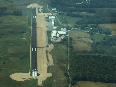
Facility Name: HOLMES COUNTY
City Name: MILLERSBURG
County: HOLMES
State abbrev: OH
State Name: OHIO
   
Ownership: PUBLICLY OWNED
Use: OPEN TO THE PUBLIC
Owner's Name: HOLMES CO ARPT AUTH
Address: 10 S CLAY ST
 MILLERSBURG, OH 44654-1329
Owner's Phone: 330-674-8625
  
Manager's Name: LARRY CLARK
Address: 4501 TOWNSHIP ROAD 307
 MILLERSBURG, OH 44654-9656
Phone: 330-674-0674; CELL 330-231-3715.
   
FAA Region: GREAT LAKES
FAA Field Office: DET


Sunrise / Sunset times for HOLMES COUNTY

DateSunriseSunset
04/24/24 Wednesday6:3520:17
04/25/24 Thursday6:3420:18
04/26/24 Friday6:3220:19
04/27/24 Saturday6:3120:20
04/28/24 Sunday6:3020:21
04/29/24 Monday6:2820:22
04/30/24 Tuesday6:2720:23
05/01/24 Wednesday6:2620:24
05/02/24 Thursday6:2520:25
05/03/24 Friday6:2320:26
05/04/24 Saturday6:2220:27
05/05/24 Sunday6:2120:29
05/06/24 Monday6:2020:30
05/07/24 Tuesday6:1920:31

Airport Facilities

Airport Attendance ScheduleMON-FRI 0800-1700, SAT 0900-1700, SUN 1200-1700; UNATNDD MAJ HOLS.
Airport Status OPERATIONAL (This Status can change at any time - please check NOTAMS)
Airport Lighting ScheduleACTVT MIRL RY 09/27, PAPI RY 27 AND REIL RYS 09 & 27 - 123.4.
Airport Storage AvailableTie Downs, Hanger
Extra Services AvailableFlight Instruction, Aircraft Rental
Wind IndicatorYES - (lighted)
Control TowerNO
CTAF Frequency123.000
Unicom Frequency123.000
Rotating Beacon ColorWG
Segmented CircleNO
Landing FeeNO

Airport Inspection Data

Airport InspectedSTATE - performed by STATE AERONAUTICAL PERSONNEL
Inspection Date09/07/2022

Airport Services

Type of Fuel AvailableGrade 100LL, JET A
Airframe Repair ServiceMAJOR
Power Plant Repair ServiceMAJOR

Geographic Data

LatitudeN4032.2
LongitudeW08157.4 (ESTIMATED)
Arpt Elevation1226ft (SURVEYED)
Magnetic Variation08W
2 miles SWof MILLERSBURG
Traffic Pattern Altitude
Sectional ChartDETROIT

Aircraft Data

Operations (Reported)YearlyAvg. Daily
General Aviation Transient 500014
General Aviation Local 1500041
Air Taxi 5001
Commerical 00
Commuter 00
Military 10003
Aircraft based on Field
General Aviation Singles 16
General Aviation Multi 1
Jet Aircraft 1
General Aviation Helicopters 0
Military Aircraft 0
Gliders 0
Ultralights 0

FAA Services

FSS on field NO
FSS tie-in CLEVELAND
FSS Phone 1-800-WX-BRIEF
Who issues Notams CLE
Notam D service at airport YES
ARTCC Name INDIANAPOLIS

Federal Status

Airport Certification
Aircraft Rescue & Firefighting IndexNone
Airport of EntryNo
Custom Landing RightsNo
Joint Civil/MilitaryNo
Military Landing rightsYES

Federal Agreements

NATIONAL PLAN OF INTEGRATED AIRPORT SYSTEMS (NPIAS)

Remarks

DEER ON & INVOF ARPT.
FOR CD CTC INDIANAPOLIS ARTCC AT 317-247-2411.
Airport Communications & Frequencies:
CTAF Frequency:
123.000
Unicom Frequency:
123.000
Remarks
  • APCH/DEP SVC PRVDD BY INDIANAPOLIS ARTCC ON FREQS 124.45/323.275 (ZANESVILLE RCAG).
  • Runway Identifications
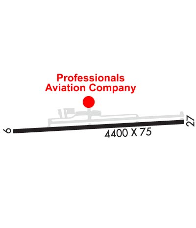
    Runway Identification: 09/27
    Length: 4400 ft
    Width: 75 ft
    Surface: ASPHALT-FAIR CONDITION
    Edge lights: Medium Intensity

    Treatment: NONE

     Runway: 09   Runway: 27
    Mag heading: 95°Mag heading: 275°
    Rwy Slope: -.98% DownRwy Slope: .98% Up
    Approach: Approach:
    Pattern: Left TrafficPattern: Left Traffic
    Markings: NONPRECISION INSTRUMENTMarkings: NONPRECISION INSTRUMENT
    Marking Condition: FAIRMarking Condition: FAIR
    Arresting Dev: Arresting Dev:
    Lat & Long: N4032.2  W08157.8Lat. & Long.: N4032.2  W08156.9
    Elev: 1226.5 ft. MSLElev: 1183.2 ft. MSL
    TCH: TCH: 25 ft. AGL
    Visual Glide Path: Visual Glide Path: 3.00 degrees
    Displaced Threshold: NoDisplaced Threshold: No
    Touchdown Zone: YESTouchdown Zone: YES
    Touchdown Elev.: 1226.5 feetTouchdown Elev.: 1214.9 feet
    Visual Glide Slope: Visual Glide Slope: 2-Light PAPI on LEFT side of Runway
    RVR Equipment: RVR Equipment:
    RVV Equipment: NORVV Equipment: NO
    Approach Lights: Approach Lights:
    REIL: YESREIL: YES
    Centerline Lights: NOCenterline Lights: NO
    Touchdown lights: NOTouchdown lights: NO
    Runway Category: Runway with a Non-precision ApproachRunway Category: Runway with a Non-precision Approach
    Declared Distances: Declared Distances:
    Obstructions: TREESObstructions:
    Marked: NOT Marked/LightedMarked:
    Clearance slope: 18:1Clearance slope: 20:1
    Obstruction height: 74 feet AGLObstruction height:
    Dist. from runway: 1537 feetDist. from runway:
    Centerline offset: 224 right of centerlineCenterline offset:
    Comments: Comments:
    C:8/P: