Current Weather/Notams (Metars, TAFs, Notams, NWS Forecast, PIREPS, and nearby weather)
Customs Information Send updates to Support@FltPlan.com
Customs Not Available
Database effective 04/18/2024
Airport Diagram might not be current.
|
| Facility Name: | HARFORD COUNTY |
| City Name: | CHURCHVILLE |
| County: | HARFORD |
| State abbrev: | MD |
| State Name: | MARYLAND |
| | |
| Ownership: | PRIVATELY OWNED |
| Use: | OPEN TO THE PUBLIC |
| Owner's Name: | HARFORD CTY ARPT OWNERS GROUP INC |
| Address: | 3538-H9 ALDINO ROAD |
| | CHURCHVILLE, MD 21028 |
| Owner's Phone: | 410-836-2828 |
| | |
| Manager's Name: | KEVIN HESS |
| Address: | 3538-H9 ALDINO RD |
| | CHURCHVILLE, MD 21028 |
| Phone: | 410-836-2828 |
| | |
| FAA Region: | EASTERN |
| FAA Field Office: | DCA |
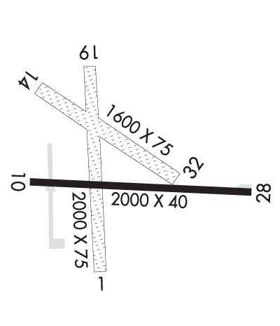
Runway Identifications
Runway Identification: 01/19Length: 2850 ft
Width: 75 ft
Surface: ASPHALT-GOOD CONDITION
Edge lights: Medium IntensityTreatment: NONE
| | Runway: 01 | | Runway: 19 |
| Mag heading: | 8° | Mag heading: | 188° |
| Rwy Slope: | .27% Up | Rwy Slope: | -.27% Down |
| Approach: | | Approach: | |
| Pattern: | Left Traffic | Pattern: | Left Traffic |
| Markings: | NONPRECISION INSTRUMENT | Markings: | NONPRECISION INSTRUMENT |
| Marking Condition: | GOOD | Marking Condition: | GOOD |
| Arresting Dev: | | Arresting Dev: | |
| Lat & Long: | N3933.9 W07612.2 | Lat. & Long.: | N3934.4 W07612.3 |
| Elev: | 403.9 ft. MSL | Elev: | 411.5 ft. MSL |
| TCH: | 26 ft. AGL | TCH: | 42 ft. AGL |
| Visual Glide Path: | 3.50 degrees | Visual Glide Path: | 3.25 degrees |
| Displaced Threshold: | No | Displaced Threshold: | 160 feet |
| Touchdown Zone: | YES | Touchdown Zone: | YES |
| Touchdown Elev.: | 411.5 feet | Touchdown Elev.: | 409.9 feet |
| Visual Glide Slope: | 2-Light PAPI on LEFT side of Runway | Visual Glide Slope: | 2-Light PAPI on LEFT side of Runway |
| RVR Equipment: | | RVR Equipment: | |
| RVV Equipment: | NO | RVV Equipment: | NO |
| Approach Lights: | | Approach Lights: | |
| REIL: | YES | REIL: | YES |
| Centerline Lights: | NO | Centerline Lights: | NO |
| Touchdown lights: | NO | Touchdown lights: | NO |
| Runway Category: | Runway with a Visual Approach | Runway Category: | Runway with a Visual Approach |
| Declared Distances: | | Declared Distances: | |
| Obstructions: | PLINE | Obstructions: | PLINE |
| Marked: | LIGHTED | Marked: | MARKED |
| Clearance slope: | 26:1 | Clearance slope: | 17:1 |
| Obstruction height: | 25 feet AGL | Obstruction height: | 62 feet AGL |
| Dist. from runway: | 856 feet | Dist. from runway: | 1277 feet |
| Centerline offset: | 112 left of centerline | Centerline offset: | |
| Comments: | | Comments: | |
Runway Identification: 10/28Length: 2015 ft
Width: 40 ft
Surface: ASPHALT-FAIR CONDITION
Edge lights: Non-Standard Lighting SystemTreatment: NONE
| | Runway: 10 | | Runway: 28 |
| Mag heading: | 104° | Mag heading: | 284° |
| Rwy Slope: | -1.37% Down | Rwy Slope: | 1.37% Up |
| Approach: | | Approach: | |
| Pattern: | Left Traffic | Pattern: | Left Traffic |
| Markings: | NONPRECISION INSTRUMENT | Markings: | BASIC |
| Marking Condition: | FAIR | Marking Condition: | FAIR |
| Arresting Dev: | | Arresting Dev: | |
| Lat & Long: | N3934.0 W07612.3 | Lat. & Long.: | N3934.0 W07611.9 |
| Elev: | 407.6 ft. MSL | Elev: | 379.9 ft. MSL |
| TCH: | | TCH: | |
| Visual Glide Path: | | Visual Glide Path: | |
| Displaced Threshold: | No | Displaced Threshold: | 101 feet |
| Touchdown Zone: | YES | Touchdown Zone: | YES |
| Touchdown Elev.: | 407.6 feet | Touchdown Elev.: | 407.6 feet |
| Visual Glide Slope: | | Visual Glide Slope: | |
| RVR Equipment: | | RVR Equipment: | |
| RVV Equipment: | NO | RVV Equipment: | NO |
| Approach Lights: | | Approach Lights: | |
| REIL: | YES | REIL: | YES |
| Centerline Lights: | NO | Centerline Lights: | NO |
| Touchdown lights: | NO | Touchdown lights: | NO |
| Runway Category: | Runway with a Visual Approach | Runway Category: | Runway with a Visual Approach |
| Declared Distances: | | Declared Distances: | |
| Obstructions: | TREES | Obstructions: | TREES |
| Marked: | NOT Marked/Lighted | Marked: | NOT Marked/Lighted |
| Clearance slope: | 17:1 | Clearance slope: | 4:1; RWY 28 APCH RATIO 11:1 TO DSPLCD THR AT CNTRLN. |
| Obstruction height: | 63 feet AGL | Obstruction height: | 63 feet AGL |
| Dist. from runway: | 1299 feet | Dist. from runway: | 486 feet |
| Centerline offset: | 45 left of centerline | Centerline offset: | 98 feet left of centerline |
| Comments: | | Comments: | 17 FT TREES 122 FT OUT, 11 FT LEFT. |


