Click here for more info on on SMS!

K0V7

KAYENTA
KAYENTA
AZ
Time Zone: Mountain
Lat: N 3643.0
Long: W 11013.7
Elev: 5688
Var: -13
Longest Runway: 7101
AWOS: 119.32
CTAF: 122.9

FBO & Flight Services info for K0V7

FBOs: Update your Fuel Prices

AIRPORTPh: 928-697-8404
-
Freq: 122.9
Service
Jet
100LL
SAF
MoGas
Fuel Avail: NO FUEL AVAILABLE
Full        Last Update: 04/23/2024 05:40:08

Self        
AWOSPh: 928-697-3638
-
Freq: 119.32  
If you are an FBO, call 1-203-262-1700 to update your info or email: FltPlan.Advertising@garmin.com
Advertise your FBO on FltPlan.com

Runway & Approach Info for K0V7
Rwy
Length
Land Dist**
Approach*
  Rwy
Length
Land Dist**
Approach*
05
7101x75  7101'          
 
  
23
  7101x75  7101'          
 
 * only ILS, LOC, LDA, and SDF approaches to a specific runway are shown
** For any Declared Landing Distance Available, please see A/FD or Approach plates
Runway Weight Capability (lbs.) Help
Runway IDSingle WheelDouble WheelDouble Tandem WheelDual Double Wheel
05/2312,500N/AN/AN/A
These numbers are Advisory and are not limits.   The Airport Manager should have more accurate Weight Limits
Approach Charts
FltPlan does not have IFR approach charts available for K0V7.
Current Weather/Notams
Customs Information Send updates to Support@FltPlan.com
Customs Not Available
Database effective 05/16/2024
Airport Diagram of K0V7
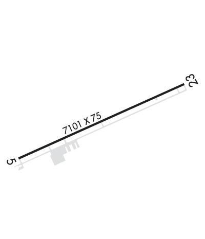
Airport Diagram might not be current.

Facility Name: KAYENTA
City Name: KAYENTA
County: NAVAJO
State abbrev: AZ
State Name: ARIZONA
   
Ownership: PUBLICLY OWNED
Use: OPEN TO THE PUBLIC
Owner's Name: KAYENTA TOWNSHIP
Address: P.O. BOX 1490, , PO BOX 4620
 KAYENTA, AZ 86033
Owner's Phone: (928) 697-8451
  
Manager's Name: KENNETH LEE; TOWN MANAGER: GERALDINE LAUGHTER, 928-697-8451.
Address: PUBLIC WORKS DEPT. OF SOLID WASTE, P.O. BOX 1490
 KAYENTA, AZ 86033
Phone: 928-697-8404
   
FAA Region: WESTERN-PACIFIC
FAA Field Office: PHX


Sunrise / Sunset times for KAYENTA

DateSunriseSunset
04/22/24 Monday6:3720:02
04/23/24 Tuesday6:3620:03
04/24/24 Wednesday6:3420:04
04/25/24 Thursday6:3320:05
04/26/24 Friday6:3220:06
04/27/24 Saturday6:3120:07
04/28/24 Sunday6:3020:08
04/29/24 Monday6:2820:08
04/30/24 Tuesday6:2720:09
05/01/24 Wednesday6:2620:10
05/02/24 Thursday6:2520:11
05/03/24 Friday6:2420:12
05/04/24 Saturday6:2320:13
05/05/24 Sunday6:2220:14

Airport Facilities

Airport Attendance ScheduleUNATTENDED
Airport Status OPERATIONAL (This Status can change at any time - please check NOTAMS)
Airport Lighting ScheduleACTVT PAPI RWY 05 & 23; MIRL RWY 05/23 - CTAF.
Airport Storage AvailableTie Downs
Extra Services AvailableNONE
Wind IndicatorYES - (unlit)
Control TowerNO
CTAF Frequency122.900
Unicom Frequency
Rotating Beacon ColorWG
Segmented CircleYES
Landing FeeNO

Airport Inspection Data

Airport InspectedSTATE - performed by PRIVATE CONTRACT PERSONNEL
Inspection Date05/07/2022

Airport Services

Type of Fuel AvailableNone
Airframe Repair ServiceNONE
Power Plant Repair ServiceNONE

Geographic Data

LatitudeN3643.0
LongitudeW11013.7 (ESTIMATED)
Arpt Elevation5687ft (SURVEYED)
Magnetic Variation13E
2 miles SEof KAYENTA
Traffic Pattern Altitude
Sectional ChartDENVER

Aircraft Data

Operations (Reported)YearlyAvg. Daily
General Aviation Transient 5001
General Aviation Local 00
Air Taxi 15004
Commerical 00
Commuter 00
Military 00
Aircraft based on Field
General Aviation Singles 0
General Aviation Multi 0
Jet Aircraft 0
General Aviation Helicopters 0
Military Aircraft 0
Gliders 0
Ultralights 0

FAA Services

FSS on field NO
FSS tie-in PRESCOTT
FSS Phone 1-800-WX-BRIEF
Who issues Notams PRC
Notam D service at airport YES
ARTCC Name DENVER

Federal Status

Airport Certification
Aircraft Rescue & Firefighting IndexNone
Airport of EntryNo
Custom Landing RightsNo
Joint Civil/MilitaryNo
Military Landing rightsNo

Federal Agreements

NATIONAL PLAN OF INTEGRATED AIRPORT SYSTEMS (NPIAS)
GRANT AGREEMENTS UNDER FAAP/ADAP/AIP
ASSURANCES PURSUANT TO TITLE VI, CIVIL RIGHTS ACT OF 1964

Remarks

NUMEROUS RWY HOLD & TWY GUIDANCE SIGNS INOPERATIVE.
GATE CODE: 1863.
Runway Identifications
Runway Identification: 05/23
Length: 7101 ft
Width: 75 ft
Surface: ASPHALT-GOOD CONDITION
Edge lights: Medium Intensity

Treatment: NONE

 Runway: 05   Runway: 23
Mag heading: 53°Mag heading: 233°
Rwy Slope: -.92% DownRwy Slope: .92% Up
Approach: Approach:
Pattern: Left TrafficPattern: Left Traffic
Markings: NONPRECISION INSTRUMENTMarkings: NONPRECISION INSTRUMENT
Marking Condition: GOODMarking Condition: GOOD
Arresting Dev: Arresting Dev:
Lat & Long: N3642.7  W11014.4Lat. & Long.: N3643.2  W11013.0
Elev: 5687.5 ft. MSLElev: 5622.2 ft. MSL
TCH: 27 ft. AGLTCH: 38 ft. AGL
Visual Glide Path: 3.00 degreesVisual Glide Path: 3.00 degrees
Displaced Threshold: NoDisplaced Threshold: No
Touchdown Zone: YESTouchdown Zone: YES
Touchdown Elev.: 5687.5 feetTouchdown Elev.: 5651.1 feet
Visual Glide Slope: 2-Light PAPI on LEFT side of RunwayVisual Glide Slope: 2-Light PAPI on LEFT side of Runway
RVR Equipment: RVR Equipment:
RVV Equipment: NORVV Equipment: NO
Approach Lights: Approach Lights:
REIL: NOREIL: NO
Centerline Lights: NOCenterline Lights: NO
Touchdown lights: NOTouchdown lights: NO
Runway Category: Runway with a Visual ApproachRunway Category: Runway with a Visual Approach
Declared Distances: Declared Distances:
Comments: +3 FT BRUSH 70-200 FT FM THR, 50-125 FT RIGHT OF CNTRLN; 70-200 FT FM THR, 50-125 FT LEFT OF CNTRLN.Comments:
C:1/P: