Click here for more info on on SMS!

K0V4

BROOKNEAL/CAMPBELL COUNTY
BROOKNEAL
VA
Time Zone: Eastern
Lat: N 3708.5
Long: W 07901.0
Elev: 597
Var: +09
Longest Runway: 3798
AWOS: 120.57
CTAF: 122.7

FBO & Flight Services info for K0V4

FBOs: Update your Fuel Prices
Unattended airport, self-serve fuel only at this location.
Ph: 240-750-0199
-
Freq: 122.7Website-
Service
Jet
100LL
SAF
MoGas
Fuel Avail: SS Fuel Airfield is Not Attended Terminal building open for pilots & pax; Restrooms available
Full        Last Update: 04/17/2024 08:16

Self  6.25    
Misc. Info: Address: 133 RUNWAY RD   GLADYS, VA 24554

AWOSPh: 434-283-7826
-
Freq: 120.57  
If you are an FBO, call 1-203-262-1700 to update your info or email: FltPlan.Advertising@garmin.com
Advertise your FBO on FltPlan.com

Runway & Approach Info for K0V4
Rwy
Length
Land Dist**
Approach*
  Rwy
Length
Land Dist**
Approach*
06
3798x60  3798'          
 
  
24
  3798x60  3798'          
 
 * only ILS, LOC, LDA, and SDF approaches to a specific runway are shown
** For any Declared Landing Distance Available, please see A/FD or Approach plates
Runway Weight Capability (lbs.) Help
Runway IDSingle WheelDouble WheelDouble Tandem WheelDual Double Wheel
06/2412,500N/AN/AN/A
These numbers are Advisory and are not limits.   The Airport Manager should have more accurate Weight Limits
Approach Charts
Approaches    
Current Weather/Notams
Customs Information Send updates to Support@FltPlan.com
Customs Not Available
Database effective 05/16/2024
Airport Diagram of K0V4
Airport Diagram might not be current.

Facility Name: BROOKNEAL/CAMPBELL COUNTY
City Name: BROOKNEAL
County: CAMPBELL
State abbrev: VA
State Name: VIRGINIA
   
Ownership: PUBLICLY OWNED
Use: OPEN TO THE PUBLIC
Owner's Name: BROOKNEAL/CAMPBELL CO. AUTH
Address: PO BOX 100, 133 RUNWAY ROAD
 RUSTBURG, VA 24588
Owner's Phone: 434-592-9595
  
Manager's Name: BOB GILLESPIE
Address: 85 CARDEN LANE, PO BOX 100
 GLADYS, VA 24554
Phone: 240-750-0199
   
FAA Region: EASTERN
FAA Field Office: DCA


Sunrise / Sunset times for BROOKNEAL/CAMPBELL COUNTY

DateSunriseSunset
04/23/24 Tuesday6:3019:59
04/24/24 Wednesday6:2920:00
04/25/24 Thursday6:2820:01
04/26/24 Friday6:2620:02
04/27/24 Saturday6:2520:02
04/28/24 Sunday6:2420:03
04/29/24 Monday6:2320:04
04/30/24 Tuesday6:2220:05
05/01/24 Wednesday6:2120:06
05/02/24 Thursday6:2020:07
05/03/24 Friday6:1820:08
05/04/24 Saturday6:1720:09
05/05/24 Sunday6:1620:10
05/06/24 Monday6:1520:10

Airport Facilities

Airport Attendance ScheduleUNATTENDED
Airport Status OPERATIONAL (This Status can change at any time - please check NOTAMS)
Airport Lighting ScheduleDUSK-DAWN. MIRL RWY 06/24 PRESET LOW, TO INCR INTST AND ACTVT REIL RWY 06 AND 24 - CTAF.
Airport Storage AvailableTie Downs
Extra Services AvailableNONE
Wind IndicatorYES - (lighted)
Control TowerNO
CTAF Frequency122.700
Unicom Frequency122.700
Rotating Beacon ColorWG
Segmented CircleYES
Landing FeeNO

Airport Inspection Data

Airport InspectedSTATE - performed by STATE AERONAUTICAL PERSONNEL
Inspection Date04/20/2021

Airport Services

Type of Fuel AvailableNone
Airframe Repair ServiceNone
Power Plant Repair ServiceNone

Geographic Data

LatitudeN3708.5
LongitudeW07901.0 (ESTIMATED)
Arpt Elevation596ft (SURVEYED)
Magnetic Variation09W
6 miles NWof BROOKNEAL
Traffic Pattern Altitude
Sectional ChartCINCINNATI

Aircraft Data

Operations (Reported)YearlyAvg. Daily
General Aviation Transient 320
General Aviation Local 11343
Air Taxi 80
Commerical 00
Commuter 00
Military 80
Aircraft based on Field
General Aviation Singles 5
General Aviation Multi 0
Jet Aircraft 0
General Aviation Helicopters 0
Military Aircraft 0
Gliders 0
Ultralights 0

FAA Services

FSS on field NO
FSS tie-in LEESBURG
FSS Phone 1-800-WX-BRIEF
Who issues Notams DCA
Notam D service at airport YES
ARTCC Name WASHINGTON

Federal Status

Airport Certification
Aircraft Rescue & Firefighting IndexNone
Airport of EntryNo
Custom Landing RightsNo
Joint Civil/MilitaryNo
Military Landing rightsYES

Federal Agreements

NATIONAL PLAN OF INTEGRATED AIRPORT SYSTEMS (NPIAS)
GRANT AGREEMENTS UNDER FAAP/ADAP/AIP
ASSURANCES PURSUANT TO TITLE VI, CIVIL RIGHTS ACT OF 1964

Remarks

ULTRALGT ACTIVITY ON & INVOF ARPT.
DEER ON & INVOF ARPT.
ROA TWR SVCS AVBL AT 540-563-1307.
FOR CD CTC ROANOKE APCH AT 540-563-1307.
Airport Communications & Frequencies:
CTAF Frequency:
122.700
Unicom Frequency:
122.700
ROANOKE Primary Approach Frequencies:  
125.475 EAST OF LYH VORTAC
135.0 WEST OF LYH VORTAC
254.325
ROANOKE Primary Departure Frequencies:  
125.475 EAST OF LYH VORTAC
135.0 WEST OF LYH VORTAC
254.325
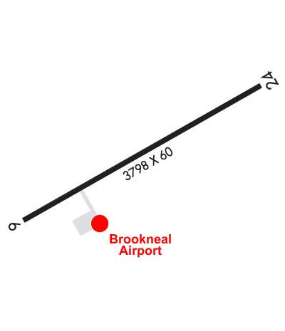
Runway Identifications
Runway Identification: 06/24
Length: 3798 ft
Width: 60 ft
Surface: ASPHALT-GOOD CONDITION
Edge lights: Medium Intensity

Treatment: NONE

 Runway: 06   Runway: 24
Mag heading: 62°Mag heading: 242°
Rwy Slope: -.19% DownRwy Slope: .19% Up
Approach: Approach:
Pattern: Left TrafficPattern: Left Traffic
Markings: NONPRECISION INSTRUMENTMarkings: NONPRECISION INSTRUMENT
Marking Condition: GOODMarking Condition: GOOD
Arresting Dev: Arresting Dev:
Lat & Long: N3708.3  W07901.3Lat. & Long.: N3708.7  W07900.7
Elev: 596.0 ft. MSLElev: 588.9 ft. MSL
TCH: 43 ft. AGLTCH: 46 ft. AGL
Visual Glide Path: 3.00 degreesVisual Glide Path: 3.00 degrees
Displaced Threshold: NoDisplaced Threshold: No
Touchdown Zone: YESTouchdown Zone: YES
Touchdown Elev.: 596.4 feetTouchdown Elev.: 596.4 feet
Visual Glide Slope: 2-Light PAPI on RIGHT side of RunwayVisual Glide Slope: 2-Light PAPI on LEFT side of Runway
RVR Equipment: RVR Equipment:
RVV Equipment: NORVV Equipment: NO
Approach Lights: Approach Lights:
REIL: YESREIL: YES
Centerline Lights: NOCenterline Lights: NO
Touchdown lights: NOTouchdown lights: NO
Runway Category: Runway with a Non-precision ApproachRunway Category: Runway with a Non-precision Approach
Declared Distances: Declared Distances:
Obstructions: TREEObstructions: TREE
Marked: NOT Marked/LightedMarked: NOT Marked/Lighted
Clearance slope: 32:1Clearance slope: 15:1
Obstruction height: 69 feet AGLObstruction height: 45 feet AGL
Dist. from runway: 2472 feetDist. from runway: 892 feet
Centerline offset: 491 right of centerlineCenterline offset: 302 feet left of centerline
Comments: Comments:
C:/P: