Click here for more info on on SMS!

K0S9

JEFFERSON COUNTY INTL
PORT TOWNSEND
WA
Time Zone: Pacific
Lat: N 4803.2
Long: W 12248.6
Elev: 110
Var: -16
Longest Runway: 3000
AWOS: 119.02
CTAF: 123.0

FBO & Flight Services info for K0S9

FBOs: Update your Fuel Prices

TAILSPIN TOMMY'SPh: 360-912-7005
-
Freq: 123.0
Service
Jet
100LL
SAF
MoGas
Full        Last Update: 03/27/2024 13:26

Self  6.99    
 Address: 300 AIRPORT RD   PORT TOWNSEND WA 98368
AWOSPh: 360-379-1199
-
Freq: 119.02  
If you are an FBO, call 1-203-262-1700 to update your info or email: FltPlan.Advertising@garmin.com
Advertise your FBO on FltPlan.com

Runway & Approach Info for K0S9
Rwy
Length
Land Dist**
Approach*
  Rwy
Length
Land Dist**
Approach*
09
3000x75  3000'          
 
  
27
  3000x75  3000'          
 
 * only ILS, LOC, LDA, and SDF approaches to a specific runway are shown
** For any Declared Landing Distance Available, please see A/FD or Approach plates
Runway Weight Capability (lbs.) Help
Runway IDSingle WheelDouble WheelDouble Tandem WheelDual Double Wheel
09/2712,500N/AN/AN/A
These numbers are Advisory and are not limits.   The Airport Manager should have more accurate Weight Limits
Approach Charts
Approaches    
Current Weather/Notams
Customs Information Send updates to Support@FltPlan.com
Phone 360-385-3777
Fax 360-385-2038

Comments 1 hr advance notice required. Business hrs 0800-1630 Monday-Friday.
Database effective 05/16/2024
Airport Diagram of K0S9
Airport Diagram might not be current.

Facility Name: JEFFERSON COUNTY INTL
City Name: PORT TOWNSEND
County: JEFFERSON
State abbrev: WA
State Name: WASHINGTON
   
Ownership: PUBLICLY OWNED
Use: OPEN TO THE PUBLIC
Owner's Name: PORT OF PORT TOWNSEND
Address: P O BOX 1180
 PORT TOWNSEND, WA 98368
Owner's Phone: 360-385-0656
  
Manager's Name: ERON BERG, EXECUTIVE DIRECTOR
Address: PO BOX 1180
 PORT TOWNSEND, WA 98368
Phone: 360-385-0656
   
FAA Region: NORTHWEST MOUNTAIN
FAA Field Office: SEA


Sunrise / Sunset times for JEFFERSON COUNTY INTL

DateSunriseSunset
04/24/24 Wednesday6:0320:16
04/25/24 Thursday6:0220:17
04/26/24 Friday6:0020:19
04/27/24 Saturday5:5820:20
04/28/24 Sunday5:5620:22
04/29/24 Monday5:5520:23
04/30/24 Tuesday5:5320:24
05/01/24 Wednesday5:5120:26
05/02/24 Thursday5:5020:27
05/03/24 Friday5:4820:29
05/04/24 Saturday5:4720:30
05/05/24 Sunday5:4520:31
05/06/24 Monday5:4420:33
05/07/24 Tuesday5:4220:34

Airport Facilities

Airport Attendance Schedule7 Days A Week 0900-1800
Airport Status OPERATIONAL (This Status can change at any time - please check NOTAMS)
Airport Lighting ScheduleACTVT REIL RWY 09; PAPI RWY 09 & 27; MIRL RWY 09/27 - CTAF.
Airport Storage AvailableTie Downs
Extra Services AvailableFlight Instruction, Aircraft Rental
Wind IndicatorYES - (lighted)
Control TowerNO
CTAF Frequency123.000
Unicom Frequency123.000
Rotating Beacon ColorWG
Segmented CircleYES
Landing FeeNO

Airport Inspection Data

Airport InspectedSTATE - performed by STATE AERONAUTICAL PERSONNEL
Inspection Date07/07/2023

Airport Services

Type of Fuel AvailableGrade 100LL; -10100LL AVAILABLE 24 HRS WITH CREDIT CARD. NO CASH SALES.
Airframe Repair ServiceMAJOR
Power Plant Repair ServiceMAJOR

Geographic Data

LatitudeN4803.2
LongitudeW12248.6 (ESTIMATED)
Arpt Elevation110ft (SURVEYED)
Magnetic Variation16E
6 miles SWof PORT TOWNSEND
Traffic Pattern Altitude890
Sectional ChartSEATTLE

Aircraft Data

Operations (Reported)YearlyAvg. Daily
General Aviation Transient 3480095
General Aviation Local 2170059
Air Taxi 15004
Commerical 00
Commuter 00
Military 1000
Aircraft based on Field
General Aviation Singles 131
General Aviation Multi 4
Jet Aircraft 1
General Aviation Helicopters 0
Military Aircraft 0
Gliders 2
Ultralights 0

FAA Services

FSS on field NO
FSS tie-in SEATTLE
FSS Phone 1-800-WX-BRIEF
Who issues Notams SEA
Notam D service at airport YES
ARTCC Name SEATTLE

Federal Status

Airport Certification
Aircraft Rescue & Firefighting IndexNone
Airport of EntryYES
Custom Landing RightsNo
Joint Civil/MilitaryNo
Military Landing rightsYES

Federal Agreements

NATIONAL PLAN OF INTEGRATED AIRPORT SYSTEMS (NPIAS)
SURPLUS PROPERTY AGREEMENT UNDER REGULATION 16-WAA

Remarks

NOISE ABATEMENT PROCS IN EFCT CTC ARPT MGR 360-385-0656. TKOF AND LNDG PROHIBITED ON TURF NEXT TO RWY.
FOR CD CTC WHIDBEY APCH AT 360-257-3310.
DEER INVOF RWY.
Airport Communications & Frequencies:
CTAF Frequency:
123.000
Unicom Frequency:
123.000
Primary Approach Frequencies:  
118.2
Primary Departure Frequencies:  
118.2
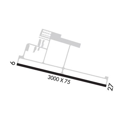
Runway Identifications
Runway Identification: 09/27
Length: 3000 ft
Width: 75 ft
Surface: ASPHALT
Edge lights: Medium Intensity

Treatment: NONE

 Runway: 09   Runway: 27
Mag heading: 88°Mag heading: 268°
Rwy Slope: -.09% DownRwy Slope: .09% Up
Approach: Approach:
Pattern: Right TrafficPattern: Left Traffic
Markings: BASICMarkings: BASIC
Marking Condition: FAIRMarking Condition: FAIR
Arresting Dev: Arresting Dev:
Lat & Long: N4803.3  W12249.0Lat. & Long.: N4803.2  W12248.3
Elev: 108.8 ft. MSLElev: 106.1 ft. MSL
TCH: 43 ft. AGLTCH: 42 ft. AGL
Visual Glide Path: 4.25 degreesVisual Glide Path: 4.25 degrees
Displaced Threshold: NoDisplaced Threshold: No
Touchdown Zone: YESTouchdown Zone: YES
Touchdown Elev.: 110.1 feetTouchdown Elev.: 110.1 feet
Visual Glide Slope: 2-Light PAPI on LEFT side of Runway; RWY 09 ARE BAFFLED BYD 6.5 DEG LEFT OF RWY CNTRLN DUE TO TRRN.Visual Glide Slope: 2-Light PAPI on RIGHT side of Runway; RWY 27 ARE BAFFLED BYD 6.5 DEG RIGHT OF RWY CNTRLN DUE TO TRRN.
RVR Equipment: RVR Equipment:
RVV Equipment: NORVV Equipment: NO
Approach Lights: Approach Lights:
REIL: YESREIL: YES
Centerline Lights: NOCenterline Lights: NO
Touchdown lights: NOTouchdown lights: NO
Runway Category: Runway with a Visual ApproachRunway Category: Runway with a Visual Approach
Declared Distances: Declared Distances:
Obstructions: TREESObstructions: TREE
Marked: NOT Marked/LightedMarked: NOT Marked/Lighted
Clearance slope: 19:1Clearance slope: 22:1
Obstruction height: 81 feet AGLObstruction height: 76 feet AGL
Dist. from runway: 1815 feetDist. from runway: 1939 feet
Centerline offset: Centerline offset: 91 feet left of centerline
Comments: Comments:
C:2/P: