Click here for more info on on SMS!

K0S7

DOROTHY SCOTT
OROVILLE
WA
Time Zone: Pacific
Lat: N 4857.5
Long: W 11924.7
Elev: 1069
Var: -21
Longest Runway: 4017
CTAF: 122.9

FBO & Flight Services info for K0S7

FBOs: Update your Fuel Prices

DOROTHY SCOTTPh: 509-476-2106
-
Freq: 122.9
Service
Jet
100LL
SAF
MoGas
Full        Last Update: 04/19/2024 11:26

Self  6.66    
 Address: 27 AIRPORT RD   OROVILLE, WA 98844
If you are an FBO, call 1-203-262-1700 to update your info or email: FltPlan.Advertising@garmin.com
Advertise your FBO on FltPlan.com

Runway & Approach Info for K0S7
Rwy
Length
Land Dist**
Approach*
  Rwy
Length
Land Dist**
Approach*
15
4017x50  4017'          
 
  
33
  4017x50  4017'          
 
 * only ILS, LOC, LDA, and SDF approaches to a specific runway are shown
** For any Declared Landing Distance Available, please see A/FD or Approach plates
Runway Weight Capability (lbs.) Help
Runway IDSingle WheelDouble WheelDouble Tandem WheelDual Double Wheel
15/335,000N/AN/AN/A
These numbers are Advisory and are not limits.   The Airport Manager should have more accurate Weight Limits
Approach Charts
FltPlan does not have IFR approach charts available for K0S7.
Current Weather/Notams
Customs Information Send updates to Support@FltPlan.com
Phone 509-476-2955
Fax N/A

Comments Business hours 24 hours a day 7 days a week
Database effective 05/16/2024
Airport Diagram of K0S7
Airport Diagram might not be current.

Facility Name: DOROTHY SCOTT INTL
City Name: OROVILLE
County: OKANOGAN
State abbrev: WA
State Name: WASHINGTON
   
Ownership: PUBLICLY OWNED
Use: OPEN TO THE PUBLIC
Owner's Name: CITY OF OROVILLE
Address: PO BOX 2200
 OROVILLE, WA 98844
Owner's Phone: 509-476-2926
  
Manager's Name: STEVE JOHNSTON
Address: PO BOX 1002
 OROVILLE, WA 98844
Phone: (509) 560-0292
   
FAA Region: NORTHWEST MOUNTAIN
FAA Field Office: SEA


Sunrise / Sunset times for DOROTHY SCOTT INTL

DateSunriseSunset
04/25/24 Thursday5:4620:06
04/26/24 Friday5:4420:07
04/27/24 Saturday5:4220:09
04/28/24 Sunday5:4120:10
04/29/24 Monday5:3920:12
04/30/24 Tuesday5:3720:13
05/01/24 Wednesday5:3520:15
05/02/24 Thursday5:3420:16
05/03/24 Friday5:3220:18
05/04/24 Saturday5:3020:19
05/05/24 Sunday5:2920:21
05/06/24 Monday5:2720:22
05/07/24 Tuesday5:2620:23
05/08/24 Wednesday5:2420:25

Airport Facilities

Airport Attendance Schedule7 Days A Week DAWN - DUSK; ON CALL FOR SERVICE ALTERNATE NUMBER, 509-322-2887
Airport Status OPERATIONAL (This Status can change at any time - please check NOTAMS)
Airport Lighting ScheduleACTVT MIRL RWY 15/33 - CTAF.
Airport Storage AvailableTie Downs
Extra Services AvailableFlight Instruction
Wind IndicatorYES - (lighted)
Control TowerNO
CTAF Frequency122.900
Unicom Frequency
Rotating Beacon ColorWG; ARPT ROTG BCN LCTD 1500' EAST OF CNTRLN OF ARPT ON TOP OF HILL APRX 900' ABOVE ARPT ELEV.
Segmented CircleYES
Landing FeeNO

Airport Inspection Data

Airport InspectedSTATE - performed by STATE AERONAUTICAL PERSONNEL
Inspection Date08/25/2021

Airport Services

Type of Fuel AvailableGrade 100LL
Airframe Repair ServiceMAJOR
Power Plant Repair ServiceMAJOR

Geographic Data

LatitudeN4857.5
LongitudeW11924.7 (ESTIMATED)
Arpt Elevation1069ft (SURVEYED)
Magnetic Variation21E
2 miles NEof OROVILLE
Traffic Pattern Altitude
Sectional ChartSEATTLE

Aircraft Data

Operations (Reported)YearlyAvg. Daily
General Aviation Transient 1500041
General Aviation Local 350010
Air Taxi 00
Commerical 00
Commuter 00
Military 5001
Aircraft based on Field
General Aviation Singles 6
General Aviation Multi 0
Jet Aircraft 0
General Aviation Helicopters 0
Military Aircraft 0
Gliders 0
Ultralights 0

FAA Services

FSS on field NO
FSS tie-in SEATTLE
FSS Phone 1-800-WX-BRIEF
Who issues Notams SEA
Notam D service at airport YES
ARTCC Name SEATTLE

Federal Status

Airport Certification
Aircraft Rescue & Firefighting IndexNone
Airport of EntryYES
Custom Landing RightsNo
Joint Civil/MilitaryNo
Military Landing rightsNo

Federal Agreements

NATIONAL PLAN OF INTEGRATED AIRPORT SYSTEMS (NPIAS)

Remarks

CUSTOMS TELEPHONE 509-476-2955.
BRUSH, ROADS & TIE DOWNS IN PRIMARY SFC.
FLIGHT NOTIFICTION SERVICE (ADCUS) AVBL.
WILDLIFE ADJ TO RY/TWY.
FOR CD CTC SEATTLE ARTCC AT 253-351-3694.
RWY 15/3 3 RY 15/33 CRACKS IN TWY PAVEMENT.
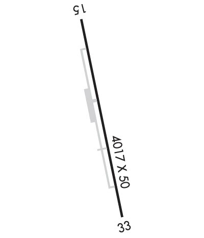
Runway Identifications
Runway Identification: 15/33
Length: 4017 ft
Width: 50 ft
Surface: ASPHALT-GOOD CONDITION
Edge lights: Medium Intensity

Treatment: NONE

 Runway: 15   Runway: 33
Mag heading: 145°Mag heading: 325°
Rwy Slope: -.15% DownRwy Slope: .15% Up
Approach: Approach:
Pattern: Right TrafficPattern: Left Traffic
Markings: BASICMarkings: BASIC
Marking Condition: FAIRMarking Condition: FAIR
Arresting Dev: Arresting Dev:
Lat & Long: N4857.9  W11924.8Lat. & Long.: N4857.2  W11924.6
Elev: 1068.5 ft. MSLElev: 1062.6 ft. MSL
TCH: TCH:
Visual Glide Path: Visual Glide Path:
Displaced Threshold: NoDisplaced Threshold: No
Touchdown Zone: YESTouchdown Zone: YES
Touchdown Elev.: 1069.0 feetTouchdown Elev.: 1068.2 feet
Visual Glide Slope: Visual Glide Slope:
RVR Equipment: RVR Equipment:
RVV Equipment: NORVV Equipment: NO
Approach Lights: Approach Lights:
REIL: NOREIL: NO
Centerline Lights: NOCenterline Lights: NO
Touchdown lights: NOTouchdown lights: NO
Runway Category: Runway with a Visual ApproachRunway Category: Runway with a Visual Approach
Declared Distances: Declared Distances:
Obstructions: BLDGObstructions: TREES
Marked: NOT Marked/LightedMarked: NOT Marked/Lighted
Clearance slope: 36:1Clearance slope: 21:1
Obstruction height: 18 feet AGLObstruction height: 13 feet AGL
Dist. from runway: 850 feetDist. from runway: 474 feet
Centerline offset: 130 right of centerlineCenterline offset:
Comments: Comments:
C:1/P: