Click here for more info on on SMS!

K0R4

CONCORDIA PARISH
VIDALIA
LA
Time Zone: Central
Lat: N 3133.7
Long: W 09130.4
Elev: 55
Var: -00
Longest Runway: 3701
CTAF: 122.8

FBO & Flight Services info for K0R4

FBOs: Update your Fuel Prices

CONCORIDA PARISHPh: 318-336-8537
-
Freq: 122.8
Service
Jet
100LL
SAF
MoGas
Fuel Avail: ~~100LL AVBL 24 HRS SELF SERVICE WITH CREDIT CARD.
Full        Last Update: 04/17/2024 05:28:40

Self        
If you are an FBO, call 1-203-262-1700 to update your info or email: FltPlan.Advertising@garmin.com
Advertise your FBO on FltPlan.com

Runway & Approach Info for K0R4
Rwy
Length
Land Dist**
Approach*
  Rwy
Length
Land Dist**
Approach*
14
3701x75  3701'          
 
  
32
  3701x75  3701'          
 
 * only ILS, LOC, LDA, and SDF approaches to a specific runway are shown
** For any Declared Landing Distance Available, please see A/FD or Approach plates
Runway Weight Capability (lbs.) Help
Runway IDSingle WheelDouble WheelDouble Tandem WheelDual Double Wheel
14/3212,000N/AN/AN/A
These numbers are Advisory and are not limits.   The Airport Manager should have more accurate Weight Limits
Approach Charts
Approaches    
Current Weather/Notams
Customs Information Send updates to Support@FltPlan.com
Customs Not Available
Database effective 04/18/2024
Airport Diagram of K0R4
Airport Diagram might not be current.

Facility Name: CONCORDIA PARISH
City Name: VIDALIA
County: CONCORDIA
State abbrev: LA
State Name: LOUISIANA
   
Ownership: PUBLICLY OWNED
Use: OPEN TO THE PUBLIC
Owner's Name: CONCORDIA PARISH AIRPORT AUTHORITY
Address: 359 NATIONAL GUARD ROAD, P. O. BOX 638
 VIDALIA, LA 71373
Owner's Phone: 318-336-7151
  
Manager's Name: CARL D. SAYERS
Address: 359 NATIONAL GUARD ROAD
 VIDALIA, LA 71373
Phone: 318-336-8537; AIRPORT PHONE 318-336-8537.
   
FAA Region: SOUTHWEST
FAA Field Office: LNM


Sunrise / Sunset times for CONCORDIA PARISH

DateSunriseSunset
04/17/24 Wednesday6:3519:37
04/18/24 Thursday6:3319:37
04/19/24 Friday6:3219:38
04/20/24 Saturday6:3119:39
04/21/24 Sunday6:3019:40
04/22/24 Monday6:2919:40
04/23/24 Tuesday6:2819:41
04/24/24 Wednesday6:2719:42
04/25/24 Thursday6:2619:42
04/26/24 Friday6:2519:43
04/27/24 Saturday6:2419:44
04/28/24 Sunday6:2319:44
04/29/24 Monday6:2219:45
04/30/24 Tuesday6:2119:46

Airport Facilities

Airport Attendance ScheduleUNATTENDED
Airport Status OPERATIONAL (This Status can change at any time - please check NOTAMS)
Airport Lighting ScheduleREIL RWYS 14 & 32; MIRL RWY 14/32 PRESET LOW INTST; TO INCR INTST ACTVT - CTAF. PAPI RWY 14 AND 32 OPR CONSLY.
Airport Storage AvailableTie Downs
Extra Services AvailableCrop Dusting
Wind IndicatorYES - (lighted)
Control TowerNO
CTAF Frequency122.800
Unicom Frequency122.800
Rotating Beacon ColorWG
Segmented CircleNO
Landing FeeNO

Airport Inspection Data

Airport InspectedSTATE - performed by STATE AERONAUTICAL PERSONNEL
Inspection Date03/21/2023

Airport Services

Type of Fuel AvailableGrade 100LL; -10100LL AVBL 24 HRS SELF SERVICE WITH CREDIT CARD.
Airframe Repair ServiceNone
Power Plant Repair ServiceNone

Geographic Data

LatitudeN3133.7
LongitudeW09130.4 (ESTIMATED)
Arpt Elevation54ft (SURVEYED)
Magnetic Variation00E
4 miles Wof VIDALIA
Traffic Pattern Altitude
Sectional ChartHOUSTON

Aircraft Data

Operations (Reported)YearlyAvg. Daily
General Aviation Transient 350010
General Aviation Local 650018
Air Taxi 00
Commerical 00
Commuter 00
Military 00
Aircraft based on Field
General Aviation Singles 28
General Aviation Multi 0
Jet Aircraft 0
General Aviation Helicopters 0
Military Aircraft 0
Gliders 0
Ultralights 0

FAA Services

FSS on field NO
FSS tie-in DE RIDDER
FSS Phone 1-800-WX-BRIEF
Who issues Notams DRI
Notam D service at airport YES
ARTCC Name HOUSTON

Federal Status

Airport Certification
Aircraft Rescue & Firefighting IndexNone
Airport of EntryNo
Custom Landing RightsNo
Joint Civil/MilitaryNo
Military Landing rightsYES

Federal Agreements

NATIONAL PLAN OF INTEGRATED AIRPORT SYSTEMS (NPIAS)
GRANT AGREEMENTS UNDER FAAP/ADAP/AIP
ASSURANCES PURSUANT TO TITLE VI, CIVIL RIGHTS ACT OF 1964

Remarks

400 FT TWR 2 MILES NORTH OF APCH END RY 14.
RWY 32 75 FT TREES EAST OF RWY PENETRATE TRANSITION SLOPE.
FOR CD CTC HOUSTON ARTCC AT 281-230-5622.
Airport Communications & Frequencies:
CTAF Frequency:
122.800
Unicom Frequency:
122.800
Remarks
  • APCH/DEP SVC PRVDD BY HOUSTON ARTCC (ZHU) ON FREQS 120.975/299.6 (NATCHEZ RCAG).
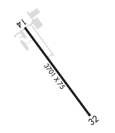
  • Runway Identifications
    Runway Identification: 14/32
    Length: 3701 ft
    Width: 75 ft
    Surface: ASPHALT-GOOD CONDITION
    Edge lights: Medium Intensity

    Treatment: NONE

     Runway: 14   Runway: 32
    Mag heading: 144°Mag heading: 324°
    Rwy Slope: .00% UpRwy Slope: .00% Down
    Approach: Approach:
    Pattern: Left TrafficPattern: Left Traffic
    Markings: NONPRECISION INSTRUMENTMarkings: NONPRECISION INSTRUMENT
    Marking Condition: GOODMarking Condition: GOOD
    Arresting Dev: Arresting Dev:
    Lat & Long: N3134.0  W09130.6Lat. & Long.: N3133.5  W09130.2
    Elev: 54.3 ft. MSLElev: 54.4 ft. MSL
    TCH: 50 ft. AGLTCH: 50 ft. AGL
    Visual Glide Path: 3.00 degreesVisual Glide Path: 3.00 degrees
    Displaced Threshold: NoDisplaced Threshold: No
    Touchdown Zone: YESTouchdown Zone: YES
    Touchdown Elev.: 54.7 feetTouchdown Elev.: 54.7 feet
    Visual Glide Slope: 2-Light PAPI on LEFT side of Runway; PAPI UNUSBL BYD 8 DEG RIGHT OF CNTRLN.Visual Glide Slope: 2-Light PAPI on LEFT side of Runway
    RVR Equipment: RVR Equipment:
    RVV Equipment: NORVV Equipment: NO
    Approach Lights: Approach Lights:
    REIL: YESREIL: YES
    Centerline Lights: NOCenterline Lights: NO
    Touchdown lights: NOTouchdown lights: NO
    Runway Category: Runway with a Visual ApproachRunway Category: Runway with a Visual Approach
    Declared Distances: Declared Distances:
    Obstructions: TREESObstructions:
    Marked: NOT Marked/LightedMarked:
    Clearance slope: 15:1Clearance slope: 20:1
    Obstruction height: 77 feet AGLObstruction height:
    Dist. from runway: 1368 feetDist. from runway:
    Centerline offset: 589 left of centerlineCenterline offset:
    Comments: Comments:
    C:/P: