Click here for more info on on SMS!

K0O2

BAKER
BAKER
CA
Time Zone: Pacific
Lat: N 3517.2
Long: W 11604.9
Elev: 922
Var: -14
Longest Runway: 3157
CTAF: 122.9

FBO & Flight Services info for K0O2

FBOs: Update your Fuel Prices

AIRPORTPh: 760-247-2371
-
Freq: 122.9
Service
Jet
100LL
SAF
MoGas
Fuel Avail: NO FUEL AVAILABLE
Full        Last Update: 04/25/2024 05:27:32

Self        
If you are an FBO, call 1-203-262-1700 to update your info or email: FltPlan.Advertising@garmin.com
Advertise your FBO on FltPlan.com

Runway & Approach Info for K0O2
Rwy
Length
Land Dist**
Approach*
  Rwy
Length
Land Dist**
Approach*
15
3157x50  3157'          
 
  
33
  3157x50  3157'          
 
 * only ILS, LOC, LDA, and SDF approaches to a specific runway are shown
** For any Declared Landing Distance Available, please see A/FD or Approach plates
Runway Weight Capability (lbs.) Help
Runway IDSingle WheelDouble WheelDouble Tandem WheelDual Double Wheel
15/33N/AN/AN/AN/A
These numbers are Advisory and are not limits.   The Airport Manager should have more accurate Weight Limits
Approach Charts
FltPlan does not have IFR approach charts available for K0O2.
Current Weather/Notams
Customs Information Send updates to Support@FltPlan.com
Customs Not Available
Database effective 05/16/2024
Airport Diagram of K0O2
Airport Diagram might not be current.

Facility Name: BAKER
City Name: BAKER
County: SAN BERNARDINO
State abbrev: CA
State Name: CALIFORNIA
   
Ownership: PUBLICLY OWNED
Use: OPEN TO THE PUBLIC
Owner's Name: US DEPT OF INTERIOR-BLM; ON LEASE TO COUNTY OF SAN BERNARDINO.
Address: BARSTOW FIELD OFFICE, 2601 BARSTOW ROAD
 BARSTOW, CA 92311
Owner's Phone: 619-256-3591
  
Manager's Name: AMGR OFFICE LCTD AT APPLE VALLEY AIRPORT.
Address: 21600 CORWIN ROAD
 APPLE VALLEY, CA 92307
Phone:
   
FAA Region: WESTERN-PACIFIC
FAA Field Office: LAX


Sunrise / Sunset times for BAKER

DateSunriseSunset
04/24/24 Wednesday6:0019:25
04/25/24 Thursday5:5919:26
04/26/24 Friday5:5819:27
04/27/24 Saturday5:5619:28
04/28/24 Sunday5:5519:29
04/29/24 Monday5:5419:29
04/30/24 Tuesday5:5319:30
05/01/24 Wednesday5:5219:31
05/02/24 Thursday5:5119:32
05/03/24 Friday5:5019:33
05/04/24 Saturday5:4919:33
05/05/24 Sunday5:4819:34
05/06/24 Monday5:4719:35
05/07/24 Tuesday5:4619:36

Airport Facilities

Airport Attendance ScheduleUNATTENDED
Airport Status OPERATIONAL (This Status can change at any time - please check NOTAMS)
Airport Lighting ScheduleACTIVATE MIRL RY 15/33 CTAF.
Airport Storage AvailableTie Downs
Extra Services AvailableNONE
Wind IndicatorYES - (lighted)
Control TowerNO
CTAF Frequency122.900
Unicom Frequency
Rotating Beacon ColorWG
Segmented CircleYES
Landing FeeNO

Airport Inspection Data

Airport InspectedSTATE - performed by STATE AERONAUTICAL PERSONNEL
Inspection Date02/01/2022

Airport Services

Type of Fuel AvailableNone
Airframe Repair ServiceNONE
Power Plant Repair ServiceNONE

Geographic Data

LatitudeN3517.2
LongitudeW11604.9 (ESTIMATED)
Arpt Elevation922ft (SURVEYED)
Magnetic Variation14E
2 miles NWof BAKER
Traffic Pattern Altitude
Sectional ChartLOS ANGELES

Aircraft Data

Operations (Reported)YearlyAvg. Daily
General Aviation Transient 5001
General Aviation Local 00
Air Taxi 00
Commerical 00
Commuter 00
Military 00
Aircraft based on Field
General Aviation Singles 0
General Aviation Multi 0
Jet Aircraft 0
General Aviation Helicopters 0
Military Aircraft 0
Gliders 0
Ultralights 0

FAA Services

FSS on field NO
FSS tie-in RIVERSIDE
FSS Phone 1-800-WX-BRIEF
Who issues Notams RAL
Notam D service at airport YES
ARTCC Name LOS ANGELES

Federal Status

Airport Certification
Aircraft Rescue & Firefighting IndexNone
Airport of EntryNo
Custom Landing RightsNo
Joint Civil/MilitaryNo
Military Landing rightsNo

Remarks

MOUNTAIN 1/2 MI W ARPT.
PUBLIC PHONE AT ARPT ACCESS.
FOR CD CTC LOS ANGELES ARTCC AT 661-575-2079.
Runway Identifications
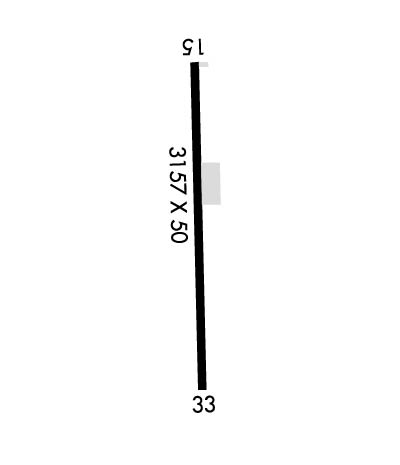
Runway Identification: 15/33
Length: 3157 ft
Width: 50 ft
Surface: ASPHALT-POOR CONDITION
Edge lights: Medium Intensity

Treatment: NONE

 Runway: 15   Runway: 33
Mag heading: 152°Mag heading: 332°
Approach: Approach:
Pattern: Left TrafficPattern: Right Traffic
Markings: BASICMarkings: BASIC
Marking Condition: FAIRMarking Condition: FAIR
Arresting Dev: Arresting Dev:
Lat & Long: N3517.4  W11605.0Lat. & Long.: N3516.9  W11604.8
Elev: N/AElev: N/A
TCH: TCH:
Visual Glide Path: Visual Glide Path:
Displaced Threshold: NoDisplaced Threshold: No
Touchdown Zone: NOTouchdown Zone: NO
Touchdown Elev.: Touchdown Elev.:
Visual Glide Slope: Visual Glide Slope:
RVR Equipment: RVR Equipment:
RVV Equipment: NORVV Equipment: NO
Approach Lights: Approach Lights:
REIL: NOREIL: NO
Centerline Lights: NOCenterline Lights: NO
Touchdown lights: NOTouchdown lights: NO
Runway Category: Runway with a Visual ApproachRunway Category: Runway with a Visual Approach
Declared Distances: Declared Distances:
Obstructions: Obstructions: PLINE
Marked: Marked: MARKED
Clearance slope: 50:1Clearance slope: 21:1
Obstruction height: Obstruction height: 80 feet AGL
Dist. from runway: Dist. from runway: 1925 feet
Centerline offset: Centerline offset: 94 feet left of centerline
Comments: Comments:
C:/P: