Click here for more info on on SMS!

K0N0

ROOSTERVILLE
LIBERTY
MO
Time Zone: Central
Lat: N 3917.4
Long: W 09426.5
Elev: 1004
Var: -05
Longest Runway: 2780
CTAF: 122.8

FBO & Flight Services info for K0N0

FBOs: Update your Fuel Prices

AIRE KAREPh: 816-781-7194
-
Freq: 122.8
Service
Jet
100LL
SAF
MoGas
Fuel Avail: ~~Grade 100LL; Call ahead for availability.
Full  4.25    Last Update: 04/19/2024 00:01:46

Self        
If you are an FBO, call 1-203-262-1700 to update your info or email: FltPlan.Advertising@garmin.com
Advertise your FBO on FltPlan.com

Runway & Approach Info for K0N0
Rwy
Length
Land Dist**
Approach*
  Rwy
Length
Land Dist**
Approach*
18
2780x20  2780'          
 
  
36
  2780x20  2780'          
 
 * only ILS, LOC, LDA, and SDF approaches to a specific runway are shown
** For any Declared Landing Distance Available, please see A/FD or Approach plates
Runway Weight Capability (lbs.) Help
Runway IDSingle WheelDouble WheelDouble Tandem WheelDual Double Wheel
18/36N/AN/AN/AN/A
These numbers are Advisory and are not limits.   The Airport Manager should have more accurate Weight Limits
Approach Charts
FltPlan does not have IFR approach charts available for K0N0.
Current Weather/Notams
Customs Information Send updates to Support@FltPlan.com
Customs Not Available
Database effective 04/18/2024
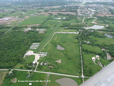
Facility Name: ROOSTERVILLE
City Name: LIBERTY
County: CLAY
State abbrev: MO
State Name: MISSOURI
   
Ownership: PRIVATELY OWNED
Use: OPEN TO THE PUBLIC
Owner's Name: AIRE KARE INC
Address: 11001 NE 112TH ST.
 KANSAS CITY, MO 64157
Owner's Phone: 816-781-7194
  
Manager's Name: PAUL STUBER
Address: 11001 NE 112TH ST.
 KANSAS CITY, MO 64057
Phone: 816-781-7194
   
FAA Region: CENTRAL
FAA Field Office: NONE
Courtesy of Ostrander, 5/13/10, runway 18/36


Click here for full scale & interactive Sectional view of K0N0


Sunrise / Sunset times for ROOSTERVILLE

DateSunriseSunset
04/18/24 Thursday6:3519:59
04/19/24 Friday6:3420:00
04/20/24 Saturday6:3320:01
04/21/24 Sunday6:3120:02
04/22/24 Monday6:3020:03
04/23/24 Tuesday6:2820:04
04/24/24 Wednesday6:2720:05
04/25/24 Thursday6:2620:06
04/26/24 Friday6:2420:07
04/27/24 Saturday6:2320:08
04/28/24 Sunday6:2220:09
04/29/24 Monday6:2120:10
04/30/24 Tuesday6:1920:11
05/01/24 Wednesday6:1820:12

Airport Facilities

Airport Attendance Schedule7 Days A Week 0800-DUSK; FOR ATTENDANT OTHER HRS CALL 816-781-4326.
Airport Status OPERATIONAL (This Status can change at any time - please check NOTAMS)
Airport Lighting ScheduleACTVT MIRL RY 18/36 - CTAF.
Airport Storage AvailableTie Downs
Extra Services AvailableFlight Instruction, Aircraft Rental
Wind IndicatorYES - (unlit)
Control TowerNO
CTAF Frequency122.800
Unicom Frequency122.800
Rotating Beacon Color
Segmented CircleNO
Landing FeeNO

Airport Inspection Data

Airport InspectedSTATE - performed by STATE AERONAUTICAL PERSONNEL
Inspection Date06/29/2021

Airport Services

Type of Fuel AvailableGrade 100LL
Airframe Repair ServiceMAJOR
Power Plant Repair ServiceMAJOR

Geographic Data

LatitudeN3917.4
LongitudeW09426.5 (ESTIMATED)
Arpt Elevation1004ft (SURVEYED)
Magnetic Variation05E
3 miles NWof LIBERTY
Traffic Pattern Altitude
Sectional ChartKANSAS CITY

Aircraft Data

Operations (Reported)YearlyAvg. Daily
General Aviation Transient 6202
General Aviation Local 700019
Air Taxi 00
Commerical 00
Commuter 00
Military 00
Aircraft based on Field
General Aviation Singles 63
General Aviation Multi 2
Jet Aircraft 0
General Aviation Helicopters 0
Military Aircraft 0
Gliders 0
Ultralights 0

FAA Services

FSS on field NO
FSS tie-in COLUMBIA
FSS Phone 1-800-WX-BRIEF
Who issues Notams COU
Notam D service at airport YES
ARTCC Name KANSAS CITY

Federal Status

Airport Certification
Aircraft Rescue & Firefighting IndexNone
Airport of EntryNo
Custom Landing RightsNo
Joint Civil/MilitaryNo
Military Landing rightsNo

Remarks

WILDLIFE ON & INVOF RY ESPECIALLY EARLY MORNING HRS.
NSTD RY SAFETY AREAS BEYOND BOTH RY ENDS; RY 18 END LARGE DROP OFF; RY 36 HAS 4 FT FENCE 15 FT FM RY END.
FOR CD CTC KANSAS CITY APCH AT 816-329-2710.
RWY 18/3 6 FIRST 50 FT ON NORTH END STEEP SLOPE; RY ALNMT CROOKED.
RWY 18/3 6 NSTD MIRL; LGTS 40-50 FT LEFT & RIGHT OF CNTRLN AT 100 FT DSTCS ON WEST SIDE; VARIOUS DSTCS ON EAST SIDE; 2 RED THLD LGTS AT EACH THLD.
Runway Identifications
Runway Identification: 18/36
Length: 2780 ft
Width: 20 ft
Surface: ASPHALT-GOOD CONDITION
Edge lights: Non-Standard Lighting System

Treatment: NONE

 Runway: 18   Runway: 36
Mag heading: N/AMag heading: N/A
Rwy Slope: .04% UpRwy Slope: -.04% Down
Approach: Approach:
Pattern: Left TrafficPattern: Left Traffic
Markings: NONSTANDARDMarkings: NONSTANDARD
Marking Condition: GOOD; RWY 18 NSTD NPI MARKINGS; SMALL NR DESIGNATIONS, THLD MARKINGS, & DASHED CNTRLN.Marking Condition: GOOD; RWY 36 NSTD BASIC MARKINGS; SMALL NR DESIGNATIONS & DASHED CNTRLN.
Arresting Dev: Arresting Dev:
Lat & Long: N3917.6  W09426.5Lat. & Long.: N3917.2  W09426.6
Elev: 1003.0 ft. MSLElev: 1004.0 ft. MSL
TCH: TCH:
Visual Glide Path: Visual Glide Path:
Displaced Threshold: NoDisplaced Threshold: No
Touchdown Zone: NOTouchdown Zone: NO
Touchdown Elev.: Touchdown Elev.:
Visual Glide Slope: Visual Glide Slope:
RVR Equipment: RVR Equipment:
RVV Equipment: NORVV Equipment: NO
Approach Lights: Approach Lights:
REIL: NOREIL: NO
Centerline Lights: NOCenterline Lights: NO
Touchdown lights: NOTouchdown lights: NO
Runway Category: Runway with a Visual ApproachRunway Category: Runway with a Visual Approach
Declared Distances: Declared Distances:
Obstructions: TREESObstructions: TREES
Marked: NOT Marked/LightedMarked: NOT Marked/Lighted
Clearance slope: 4:1Clearance slope: 10:1
Obstruction height: 62 feet AGLObstruction height: 26 feet AGL
Dist. from runway: 505 feetDist. from runway: 482 feet
Centerline offset: 150 right of centerlineCenterline offset: 150 feet right of centerline
Comments: RWY 18 1-20 FT GND; BLDGS & AUTO PARKING AREA 0-200 FT FM RY END, 10-125 FT R.Comments: RWY 36 +1-4 FT GND & FC 25-30 FT FROM RY END L & R.
C:/P: