Current Weather/Notams (Metars, TAFs, Notams, NWS Forecast, PIREPS, and nearby weather)
Customs Information Send updates to Support@FltPlan.com
Customs Not Available
Database effective 05/16/2024
Airport Diagram might not be current.
|
| Facility Name: | HUMPHREYS COUNTY |
| City Name: | WAVERLY |
| County: | HUMPHREYS |
| State abbrev: | TN |
| State Name: | TENNESSEE |
| | |
| Ownership: | PUBLICLY OWNED |
| Use: | OPEN TO THE PUBLIC |
| Owner's Name: | HUMPHREYS COUNTY |
| Address: | COUNTY COURTHOUSE, RM 1, ANNEX BLDG |
| | WAVERLY, TN 37185 |
| Owner's Phone: | 931-296-7795 |
| | |
| Manager's Name: | JEFF FINCHER |
| Address: | 1005 AIRPORT ROAD |
| | WAVERLY, TN 37185 |
| Phone: | 931-296-2719; 205-496-8130 |
| | |
| FAA Region: | SOUTHERN |
| FAA Field Office: | MEM |
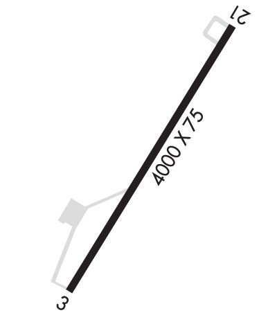
Runway Identifications
Runway Identification: 03/21Length: 4000 ft
Width: 75 ft
Surface: ASPHALT-GOOD CONDITION
Edge lights: Medium IntensityTreatment: NONE
| | Runway: 03 | | Runway: 21 |
| Mag heading: | 32° | Mag heading: | 212° |
| Rwy Slope: | -.38% Down | Rwy Slope: | .38% Up |
| Approach: | | Approach: | |
| Pattern: | Left Traffic | Pattern: | Left Traffic |
| Markings: | NONPRECISION INSTRUMENT | Markings: | NONPRECISION INSTRUMENT |
| Marking Condition: | GOOD | Marking Condition: | GOOD |
| Arresting Dev: | | Arresting Dev: | |
| Lat & Long: | N3606.7 W08744.5 | Lat. & Long.: | N3607.3 W08744.1 |
| Elev: | 754.7 ft. MSL | Elev: | 739.5 ft. MSL |
| TCH: | 50 ft. AGL | TCH: | 50 ft. AGL |
| Visual Glide Path: | 3.00 degrees | Visual Glide Path: | 3.00 degrees |
| Displaced Threshold: | No | Displaced Threshold: | No |
| Touchdown Zone: | YES | Touchdown Zone: | YES |
| Touchdown Elev.: | 755.8 feet | Touchdown Elev.: | 755.3 feet |
| Visual Glide Slope: | 2-Light PAPI on LEFT side of Runway | Visual Glide Slope: | 2-Light PAPI on LEFT side of Runway |
| RVR Equipment: | | RVR Equipment: | |
| RVV Equipment: | NO | RVV Equipment: | NO |
| Approach Lights: | | Approach Lights: | |
| REIL: | YES | REIL: | YES |
| Centerline Lights: | NO | Centerline Lights: | NO |
| Touchdown lights: | NO | Touchdown lights: | NO |
| Runway Category: | Runway with a Non-precision Approach having visibility minimums greater than 3/4 mile | Runway Category: | Runway with a Non-precision Approach having visibility minimums greater than 3/4 mile |
| Declared Distances: | | Declared Distances: | |
| Obstructions: | TREE | Obstructions: | TREE |
| Marked: | NOT Marked/Lighted | Marked: | NOT Marked/Lighted |
| Clearance slope: | 30:1 | Clearance slope: | 10:1 |
| Obstruction height: | 114 feet AGL | Obstruction height: | 34 feet AGL |
| Dist. from runway: | 3672 feet | Dist. from runway: | 557 feet |
| Centerline offset: | 237 left of centerline | Centerline offset: | 149 feet right of centerline |
| Comments: | | Comments: | |

