Current Weather/Notams (Metars, TAFs, Notams, NWS Forecast, PIREPS, and nearby weather)
Customs Information Send updates to Support@FltPlan.com
Customs Not Available
Database effective 05/16/2024
Airport Diagram might not be current.
|
| Facility Name: | PAUL BRIDGES FLD |
| City Name: | HOHENWALD |
| County: | LEWIS |
| State abbrev: | TN |
| State Name: | TENNESSEE |
| | |
| Ownership: | PUBLICLY OWNED |
| Use: | OPEN TO THE PUBLIC |
| Owner's Name: | LEWIS COUNTY |
| Address: | COUNTY COURTHOUSE |
| | HOHENWALD, TN 38462 |
| Owner's Phone: | 931-796-3378 |
| | |
| Manager's Name: | GARY NASH |
| Address: | 1180 W MAIN ST |
| | HOHENWALD, TN 38462 |
| Phone: | 931-796-3448 |
| | |
| FAA Region: | SOUTHERN |
| FAA Field Office: | MEM |
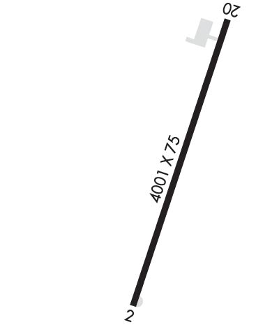
Runway Identifications
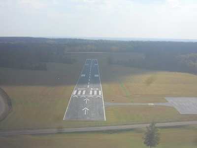
Runway Identification: 02/20Length: 4001 ft
Width: 75 ft
Surface: ASPHALT-GOOD CONDITION
Edge lights: Medium IntensityTreatment: NONE
| | Runway: 02 | | Runway: 20 |
| Mag heading: | 19° | Mag heading: | 199° |
| Rwy Slope: | .45% Up | Rwy Slope: | -.45% Down |
| Approach: | | Approach: | |
| Pattern: | Left Traffic | Pattern: | Left Traffic |
| Markings: | NONPRECISION INSTRUMENT | Markings: | BASIC |
| Marking Condition: | POOR; FADED AND PEELING. | Marking Condition: | POOR; FADED AND PEELING. |
| Arresting Dev: | | Arresting Dev: | |
| Lat & Long: | N3532.4 W08736.0 | Lat. & Long.: | N3533.1 W08735.7 |
| Elev: | 949.4 ft. MSL | Elev: | 967.5 ft. MSL |
| TCH: | 40 ft. AGL | TCH: | 40 ft. AGL |
| Visual Glide Path: | 3.00 degrees | Visual Glide Path: | 3.00 degrees |
| Displaced Threshold: | No | Displaced Threshold: | 492 feet |
| Touchdown Zone: | YES | Touchdown Zone: | YES |
| Touchdown Elev.: | 966.3 feet | Touchdown Elev.: | 972.0 feet |
| Visual Glide Slope: | 2-Light PAPI on LEFT side of Runway | Visual Glide Slope: | 2-Light PAPI on LEFT side of Runway |
| RVR Equipment: | | RVR Equipment: | |
| RVV Equipment: | NO | RVV Equipment: | NO |
| Approach Lights: | | Approach Lights: | |
| REIL: | YES | REIL: | YES |
| Centerline Lights: | NO | Centerline Lights: | NO |
| Touchdown lights: | NO | Touchdown lights: | NO |
| Runway Category: | Runway with a Non-precision Approach | Runway Category: | Runway with a Visual Approach |
| Declared Distances: | | Declared Distances: | |
| Obstructions: | TREES | Obstructions: | TREES |
| Marked: | NOT Marked/Lighted | Marked: | NOT Marked/Lighted |
| Clearance slope: | 20:1 | Clearance slope: | 10:1; APCH RATIO 20:1 TO DTHR. |
| Obstruction height: | 79 feet AGL | Obstruction height: | 71 feet AGL |
| Dist. from runway: | 1821 feet | Dist. from runway: | 939 feet |
| Centerline offset: | 37 right of centerline | Centerline offset: | 64 feet right of centerline |
| Comments: | | Comments: | |