Approach Charts
| FltPlan does not have IFR approach charts available for K0J0. |
Current Weather/Notams (Metars, TAFs, Notams, NWS Forecast, PIREPS, and nearby weather)
Customs Information Send updates to Support@FltPlan.com
Customs Not Available
Database effective 04/18/2024
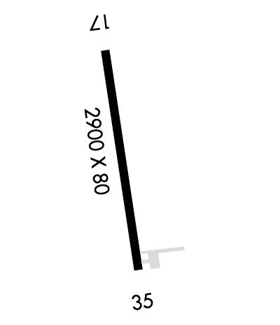
Airport Diagram might not be current.
|
| Facility Name: | ABBEVILLE MUNI |
| City Name: | ABBEVILLE |
| County: | HENRY |
| State abbrev: | AL |
| State Name: | ALABAMA |
| | |
| Ownership: | PUBLICLY OWNED |
| Use: | OPEN TO THE PUBLIC |
| Owner's Name: | CITY OF ABBEVILLE |
| Address: | PO BOX 427 |
| | ABBEVILLE, AL 36310 |
| Owner's Phone: | 334-585-6444 |
| | |
| Manager's Name: | MELISSA WILSON |
| Address: | PO BOX 427, 101 E. WASHINGTON ST |
| | ABBEVILLE, AL 36310 |
| Phone: | 334-585-6444 |
| | |
| FAA Region: | SOUTHERN |
| FAA Field Office: | JAN |
Runway Identifications
Runway Identification: 17/35Length: 2900 ft
Width: 80 ft
Surface: ASPHALT-FAIR CONDITION
Edge lights: Medium IntensityTreatment: AGGREGATE FRICTION SEAL COAT
| | Runway: 17 | | Runway: 35 |
| Mag heading: | 173° | Mag heading: | 353° |
| Rwy Slope: | -.01% Down | Rwy Slope: | .01% Up |
| Approach: | | Approach: | |
| Pattern: | Left Traffic | Pattern: | Left Traffic |
| Markings: | BASIC | Markings: | BASIC |
| Marking Condition: | GOOD | Marking Condition: | GOOD |
| Arresting Dev: | | Arresting Dev: | |
| Lat & Long: | N3136.2 W08514.3 | Lat. & Long.: | N3135.8 W08514.3 |
| Elev: | 463.1 ft. MSL | Elev: | 462.8 ft. MSL |
| TCH: | | TCH: | |
| Visual Glide Path: | | Visual Glide Path: | |
| Displaced Threshold: | No | Displaced Threshold: | No |
| Touchdown Zone: | YES | Touchdown Zone: | YES |
| Touchdown Elev.: | 463.1 feet | Touchdown Elev.: | 462.8 feet |
| Visual Glide Slope: | | Visual Glide Slope: | |
| RVR Equipment: | | RVR Equipment: | |
| RVV Equipment: | NO | RVV Equipment: | NO |
| Approach Lights: | | Approach Lights: | |
| REIL: | NO | REIL: | NO |
| Centerline Lights: | NO | Centerline Lights: | NO |
| Touchdown lights: | NO | Touchdown lights: | NO |
| Runway Category: | Runway with a Visual Approach | Runway Category: | Runway with a Visual Approach |
| Declared Distances: | | Declared Distances: | |
| Obstructions: | TREES | Obstructions: | TREE |
| Marked: | NOT Marked/Lighted | Marked: | NOT Marked/Lighted |
| Clearance slope: | 9:1 | Clearance slope: | 12:1 |
| Obstruction height: | 32 feet AGL | Obstruction height: | 9 feet AGL |
| Dist. from runway: | 499 feet | Dist. from runway: | 316 feet |
| Centerline offset: | 237 right of centerline | Centerline offset: | 98 feet right of centerline |
| Comments: | | Comments: | |

