Approach Charts
| FltPlan does not have IFR approach charts available for K0F3. |
Current Weather/Notams (Metars, TAFs, Notams, NWS Forecast, PIREPS, and nearby weather)
Customs Information Send updates to Support@FltPlan.com
Customs Not Available
Database effective 05/16/2024
Airport Diagram might not be current.
|
| Facility Name: | SPIRIT LAKE MUNI |
| City Name: | SPIRIT LAKE |
| County: | DICKINSON |
| State abbrev: | IA |
| State Name: | IOWA |
| | |
| Ownership: | PUBLICLY OWNED |
| Use: | OPEN TO THE PUBLIC |
| Owner's Name: | DICKINSON COUNTY ARPT AUTH; ARPT AUTHORITY CHAIRMAN - BRUCE SMITH - 712-332-7323. |
| Address: | BOX 702 |
| | OKOBOJI, IA 51355 |
| Owner's Phone: | 712-332-9412 |
| | |
| Manager's Name: | DICKINSON COUNTY ARPT AUTH; BRUCE SMITH |
| Address: | BOX 702 |
| | OKOBOJI, IA 51355 |
| Phone: | 712-332-9412 |
| | |
| FAA Region: | CENTRAL |
| FAA Field Office: | NONE |
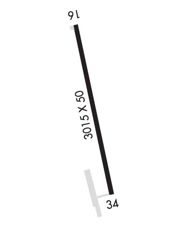
Runway Identifications
Runway Identification: 16/34Length: 3015 ft
Width: 50 ft
Surface: ASPHALT-FAIR CONDITION
Edge lights: Low IntensityTreatment: NONE
| | Runway: 16 | | Runway: 34 |
| Mag heading: | 162° | Mag heading: | 342° |
| Rwy Slope: | -.46% Down | Rwy Slope: | .46% Up |
| Approach: | | Approach: | |
| Pattern: | Left Traffic | Pattern: | Left Traffic |
| Markings: | BASIC | Markings: | BASIC |
| Marking Condition: | GOOD | Marking Condition: | GOOD |
| Arresting Dev: | | Arresting Dev: | |
| Lat & Long: | N4323.5 W09508.4 | Lat. & Long.: | N4323.0 W09508.3 |
| Elev: | 1434.0 ft. MSL | Elev: | 1420.0 ft. MSL |
| TCH: | | TCH: | |
| Visual Glide Path: | | Visual Glide Path: | |
| Displaced Threshold: | No | Displaced Threshold: | No |
| Touchdown Zone: | NO | Touchdown Zone: | NO |
| Touchdown Elev.: | | Touchdown Elev.: | |
| Visual Glide Slope: | | Visual Glide Slope: | |
| RVR Equipment: | | RVR Equipment: | |
| RVV Equipment: | NO | RVV Equipment: | NO |
| Approach Lights: | | Approach Lights: | |
| REIL: | YES | REIL: | NO |
| Centerline Lights: | NO | Centerline Lights: | NO |
| Touchdown lights: | NO | Touchdown lights: | NO |
| Runway Category: | Runway with a Visual Approach | Runway Category: | Runway with a Visual Approach |
| Declared Distances: | | Declared Distances: | |
| Obstructions: | GND | Obstructions: | TREE |
| Marked: | NOT Marked/Lighted | Marked: | NOT Marked/Lighted |
| Clearance slope: | 32:1 | Clearance slope: | 20:1 |
| Obstruction height: | 10 feet AGL | Obstruction height: | 42 feet AGL |
| Dist. from runway: | 520 feet; +30' TREES 100' RIGHT OF RWY CNTRLN EXTNDD 520' FROM AER. | Dist. from runway: | 1080 feet |
| Centerline offset: | B | Centerline offset: | 73 feet left of centerline |
| Comments: | | Comments: | |

