Current Weather/Notams (Metars, TAFs, Notams, NWS Forecast, PIREPS, and nearby weather)
Customs Information Send updates to Support@FltPlan.com
Customs Not Available
Database effective 04/18/2024
Airport Diagram might not be current.
|
| Facility Name: | WETUMPKA MUNI |
| City Name: | WETUMPKA |
| County: | ELMORE |
| State abbrev: | AL |
| State Name: | ALABAMA |
| | |
| Ownership: | PUBLICLY OWNED |
| Use: | OPEN TO THE PUBLIC |
| Owner's Name: | CITY OF WETUMPKA |
| Address: | PO BOX 1180 |
| | WETUMPKA, AL 36092 |
| Owner's Phone: | 334-567-5147 |
| | |
| Manager's Name: | LYNN WELDON |
| Address: | 1285 HIGHWAY 14 |
| | ELMORE, AL 36025 |
| Phone: | 334-285-5843 |
| | |
| FAA Region: | SOUTHERN |
| FAA Field Office: | JAN |
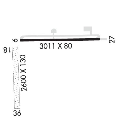
Runway Identifications
Runway Identification: 09/27Length: 3013 ft
Width: 80 ft
Surface: ASPHALT-FAIR CONDITION
Edge lights: Medium IntensityTreatment: NONE
| | Runway: 09 | | Runway: 27 |
| Mag heading: | 92° | Mag heading: | 272° |
| Rwy Slope: | -.01% Down | Rwy Slope: | .01% Up |
| Approach: | | Approach: | |
| Pattern: | Left Traffic | Pattern: | Left Traffic |
| Markings: | NONPRECISION INSTRUMENT | Markings: | NONPRECISION INSTRUMENT |
| Marking Condition: | FAIR | Marking Condition: | FAIR |
| Arresting Dev: | | Arresting Dev: | |
| Lat & Long: | N3231.8 W08620.0 | Lat. & Long.: | N3231.8 W08619.4 |
| Elev: | 196.7 ft. MSL | Elev: | 196.4 ft. MSL |
| TCH: | | TCH: | |
| Visual Glide Path: | | Visual Glide Path: | |
| Displaced Threshold: | No | Displaced Threshold: | No |
| Touchdown Zone: | YES | Touchdown Zone: | YES |
| Touchdown Elev.: | 197.1 feet | Touchdown Elev.: | 197.1 feet |
| Visual Glide Slope: | | Visual Glide Slope: | |
| RVR Equipment: | | RVR Equipment: | |
| RVV Equipment: | NO | RVV Equipment: | NO |
| Approach Lights: | | Approach Lights: | |
| REIL: | YES | REIL: | YES |
| Centerline Lights: | NO | Centerline Lights: | NO |
| Touchdown lights: | NO | Touchdown lights: | NO |
| Runway Category: | Runway with a Non-precision Approach | Runway Category: | Runway with a Non-precision Approach |
| Declared Distances: | | Declared Distances: | |
| Obstructions: | TREES | Obstructions: | TREES |
| Marked: | NOT Marked/Lighted | Marked: | NOT Marked/Lighted |
| Clearance slope: | 7:1 | Clearance slope: | 8:1 |
| Obstruction height: | 61 feet AGL | Obstruction height: | 73 feet AGL |
| Dist. from runway: | 677 feet | Dist. from runway: | 816 feet |
| Centerline offset: | 263 right of centerline | Centerline offset: | 317 feet right of centerline |
| Comments: | | Comments: | |
Runway Identification: 18/36Length: 2876 ft
Width: 130 ft
Surface: GRASS-FAIR CONDITION
Edge lights: Treatment: NONE
| | Runway: 18 | | Runway: 36 |
| Mag heading: | 184° | Mag heading: | 4° |
| Rwy Slope: | -.16% Down | Rwy Slope: | .16% Up |
| Approach: | | Approach: | |
| Pattern: | Left Traffic | Pattern: | Left Traffic |
| Markings: | BASIC | Markings: | BASIC |
| Marking Condition: | GOOD; MKD WITH 36 INCH WHITE CONES. | Marking Condition: | GOOD; MKD WITH 36 INCH WHITE CONES. |
| Arresting Dev: | | Arresting Dev: | |
| Lat & Long: | N3231.7 W08620.0 | Lat. & Long.: | N3231.3 W08620.0 |
| Elev: | 195.7 ft. MSL | Elev: | 191.0 ft. MSL |
| TCH: | | TCH: | |
| Visual Glide Path: | | Visual Glide Path: | |
| Displaced Threshold: | No | Displaced Threshold: | 983 feet |
| Touchdown Zone: | YES | Touchdown Zone: | YES |
| Touchdown Elev.: | 195.7 feet | Touchdown Elev.: | 195.7 feet |
| Visual Glide Slope: | | Visual Glide Slope: | |
| RVR Equipment: | | RVR Equipment: | |
| RVV Equipment: | NO | RVV Equipment: | NO |
| Approach Lights: | | Approach Lights: | |
| REIL: | NO | REIL: | NO |
| Centerline Lights: | NO | Centerline Lights: | NO |
| Touchdown lights: | NO | Touchdown lights: | NO |
| Runway Category: | Runway with a Visual Approach | Runway Category: | Runway with a Visual Approach |
| Declared Distances: | | Declared Distances: | |
| Obstructions: | TREES | Obstructions: | TREES |
| Marked: | MARKED | Marked: | NOT Marked/Lighted |
| Clearance slope: | 13:1 | Clearance slope: | 4:1; RWY 36 APCH RATIO 15:1 FM DSPLCD THR. |
| Obstruction height: | 69 feet AGL | Obstruction height: | 76 feet AGL |
| Dist. from runway: | 918 feet | Dist. from runway: | 344 feet |
| Centerline offset: | 160 right of centerline | Centerline offset: | 107 feet right of centerline |
| Comments: | | Comments: | |

