Approach Charts
| FltPlan does not have IFR approach charts available for K07Y. |
Current Weather/Notams (Metars, TAFs, Notams, NWS Forecast, PIREPS, and nearby weather)
Customs Information Send updates to Support@FltPlan.com
Customs Not Available
Database effective 05/16/2024
Airport Diagram might not be current.
|
| Facility Name: | HILL CITY/QUADNA MOUNTAIN |
| City Name: | HILL CITY |
| County: | AITKIN |
| State abbrev: | MN |
| State Name: | MINNESOTA |
| | |
| Ownership: | PUBLICLY OWNED |
| Use: | OPEN TO THE PUBLIC |
| Owner's Name: | CITY OF HILL CITY |
| Address: | 125 LAKE AVE E, PO BOX 160 |
| | HILL CITY, MN 55748-0160 |
| Owner's Phone: | 218-697-2301 |
| | |
| Manager's Name: | GEORGE CASPER |
| Address: | 125 LAKE AVE E, PO BOX 160 |
| | HILL CITY, MN 55748-0160 |
| Phone: | 218-244-0440 |
| | |
| FAA Region: | GREAT LAKES |
| FAA Field Office: | DMA |
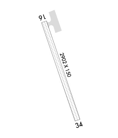
Runway Identifications
Runway Identification: 16/34Length: 2902 ft
Width: 150 ft
Surface: GRASS-GOOD CONDITION
Edge lights: Treatment: NONE
| | Runway: 16 | | Runway: 34 |
| Mag heading: | 161° | Mag heading: | 341° |
| Rwy Slope: | .08% Up | Rwy Slope: | -.08% Down |
| Approach: | | Approach: | |
| Pattern: | Right Traffic | Pattern: | Left Traffic |
| Markings: | | Markings: | |
| Marking Condition: | GOOD; YELLOW CONES. | Marking Condition: | GOOD; YELLOW CONES. |
| Arresting Dev: | | Arresting Dev: | |
| Lat & Long: | N4657.6 W09336.0 | Lat. & Long.: | N4657.1 W09335.7 |
| Elev: | 1279.1 ft. MSL | Elev: | 1281.4 ft. MSL |
| TCH: | | TCH: | |
| Visual Glide Path: | | Visual Glide Path: | |
| Displaced Threshold: | No | Displaced Threshold: | No |
| Touchdown Zone: | NO | Touchdown Zone: | NO |
| Touchdown Elev.: | | Touchdown Elev.: | |
| Visual Glide Slope: | | Visual Glide Slope: | |
| RVR Equipment: | | RVR Equipment: | |
| RVV Equipment: | NO | RVV Equipment: | NO |
| Approach Lights: | | Approach Lights: | |
| REIL: | NO | REIL: | NO |
| Centerline Lights: | NO | Centerline Lights: | NO |
| Touchdown lights: | NO | Touchdown lights: | NO |
| Runway Category: | Runway with a Visual Approach | Runway Category: | Runway with a Visual Approach |
| Declared Distances: | | Declared Distances: | |
| Obstructions: | TREES | Obstructions: | |
| Marked: | NOT Marked/Lighted | Marked: | |
| Clearance slope: | 14:1 | Clearance slope: | 20:1 |
| Obstruction height: | 50 feet AGL | Obstruction height: | |
| Dist. from runway: | 701 feet | Dist. from runway: | |
| Centerline offset: | 53 right of centerline | Centerline offset: | |
| Comments: | | Comments: | |

