Click here for more info on on SMS!

K06N

RANDALL
MIDDLETOWN
NY
Time Zone: Eastern
Lat: N 4125.9
Long: W 07423.5
Elev: 523
Var: +13
Longest Runway: 2810
CTAF: 122.8

FBO & Flight Services info for K06N

FBOs: Update your Fuel Prices

RANDALLPh: 845-343-5965
-
Freq: 122.8
Service
Jet
100LL
SAF
MoGas
Fuel Avail: ~~Grade 100LL; FUEL AVAILABLE FOR BASED AIRCRAFT OWNERS WITH SPECIAL KEY.
Full        Last Update: 04/26/2024 00:15:41

Self        
If you are an FBO, call 1-203-262-1700 to update your info or email: FltPlan.Advertising@garmin.com
Advertise your FBO on FltPlan.com

Runway & Approach Info for K06N
Rwy
Length
Land Dist**
Approach*
  Rwy
Length
Land Dist**
Approach*
08
2810x60  2247'          
 
  
26
  2810x60  2810'          
 
 * only ILS, LOC, LDA, and SDF approaches to a specific runway are shown
** For any Declared Landing Distance Available, please see A/FD or Approach plates
Runway Weight Capability (lbs.) Help
Runway IDSingle WheelDouble WheelDouble Tandem WheelDual Double Wheel
08/2625,000N/AN/AN/A
These numbers are Advisory and are not limits.   The Airport Manager should have more accurate Weight Limits
Approach Charts
Approaches    
Current Weather/Notams
Customs Information Send updates to Support@FltPlan.com
Customs Not Available
Database effective 05/16/2024
Airport Diagram of K06N
Airport Diagram might not be current.

Facility Name: RANDALL
City Name: MIDDLETOWN
County: ORANGE
State abbrev: NY
State Name: NEW YORK
   
Ownership: PRIVATELY OWNED
Use: OPEN TO THE PUBLIC
Owner's Name: AERODROME DEV CORP
Address: PO BOX 3062, 100 AIRPORT RD
 MIDDLETOWN, NY 10940
Owner's Phone: 845-343-5965
  
Manager's Name: CHARLES BRODIE
Address: P O BOX 3062, 100 AIRPORT RD
 MIDDLETOWN, NY 10940
Phone: 845-343-5965
   
FAA Region: EASTERN
FAA Field Office: NYC


Sunrise / Sunset times for RANDALL

DateSunriseSunset
04/26/24 Friday6:0019:51
04/27/24 Saturday5:5919:52
04/28/24 Sunday5:5819:53
04/29/24 Monday5:5619:54
04/30/24 Tuesday5:5519:55
05/01/24 Wednesday5:5419:56
05/02/24 Thursday5:5219:57
05/03/24 Friday5:5119:58
05/04/24 Saturday5:5019:59
05/05/24 Sunday5:4920:00
05/06/24 Monday5:4820:01
05/07/24 Tuesday5:4620:02
05/08/24 Wednesday5:4520:03
05/09/24 Thursday5:4420:04

Airport Facilities

Airport Attendance ScheduleUNATTENDED
Airport Status OPERATIONAL (This Status can change at any time - please check NOTAMS)
Airport Lighting ScheduleACTVT MIRL RWY 08/26 - CTAF.
Airport Storage AvailableTie Downs
Extra Services AvailableGlider, Glider Towing
Wind IndicatorYES - (unlit)
Control TowerNO
CTAF Frequency122.800
Unicom Frequency122.800
Rotating Beacon Color
Segmented CircleNO
Landing FeeNO

Airport Inspection Data

Airport InspectedSTATE - performed by STATE AERONAUTICAL PERSONNEL
Inspection Date08/12/2021

Airport Services

Type of Fuel AvailableNone
Airframe Repair ServiceNONE
Power Plant Repair ServiceNONE

Geographic Data

LatitudeN4125.9
LongitudeW07423.5 (ESTIMATED)
Arpt Elevation522ft (SURVEYED)
Magnetic Variation13W
2 miles SEof MIDDLETOWN
Traffic Pattern Altitude
Sectional ChartNEW YORK

Aircraft Data

Operations (Reported)YearlyAvg. Daily
General Aviation Transient 550015
General Aviation Local 1700047
Air Taxi 00
Commerical 00
Commuter 00
Military 00
Aircraft based on Field
General Aviation Singles 15
General Aviation Multi 0
Jet Aircraft 0
General Aviation Helicopters 0
Military Aircraft 0
Gliders 20
Ultralights 0

FAA Services

FSS on field NO
FSS tie-in NEW YORK
FSS Phone 1-800-WX-BRIEF
Who issues Notams ISP
Notam D service at airport YES
ARTCC Name NEW YORK

Federal Status

Airport Certification
Aircraft Rescue & Firefighting IndexNone
Airport of EntryNo
Custom Landing RightsNo
Joint Civil/MilitaryNo
Military Landing rightsNo

Federal Agreements

NATIONAL PLAN OF INTEGRATED AIRPORT SYSTEMS (NPIAS)
GRANT AGREEMENTS UNDER FAAP/ADAP/AIP
ASSURANCES PURSUANT TO TITLE VI, CIVIL RIGHTS ACT OF 1964

Remarks

HVY GLIDER & HANG GLIDER ACT ON WKENDS & HOLS.
ULTRA-LIGHT ON AND INVOF ARPT.
FOR CD CTC NEW YORK APCH AT 516-683-2448
RWY 08/2 6 SW STRENGTH IS 12.5
RWY 08/2 6 SEVERAL RWY AND TWY LGTS OTS INDEFLY.
Airport Communications & Frequencies:
CTAF Frequency:
122.800
Unicom Frequency:
122.800
NEW YORK Primary Approach Frequencies:  
132.75
363.1
NEW YORK Primary Departure Frequencies:  
132.75
363.1
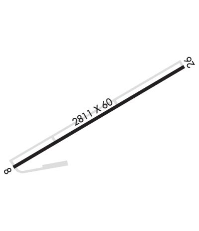
Runway Identifications
Runway Identification: 08/26
Length: 2810 ft
Width: 60 ft
Surface: ASPHALT-FAIR CONDITION
Edge lights: Medium Intensity

Treatment: NONE

 Runway: 08   Runway: 26
Mag heading: 76°Mag heading: 256°
Rwy Slope: .63% UpRwy Slope: -.63% Down
Approach: Approach:
Pattern: Left TrafficPattern: Left Traffic
Markings: NONPRECISION INSTRUMENTMarkings: NONPRECISION INSTRUMENT
Marking Condition: POOR; RUNWAY MARKINGS VERY BADLY FADEDMarking Condition: POOR
Arresting Dev: Arresting Dev:
Lat & Long: N4125.8  W07423.8Lat. & Long.: N4126.0  W07423.2
Elev: 503.0 ft. MSLElev: 520.7 ft. MSL
TCH: 44 ft. AGLTCH: 30 ft. AGL
Visual Glide Path: 4.00 degreesVisual Glide Path: 4.00 degrees
Displaced Threshold: 563 feetDisplaced Threshold: No
Touchdown Zone: YESTouchdown Zone: YES
Touchdown Elev.: 522.7 feetTouchdown Elev.: 522.7 feet
Visual Glide Slope: 2-Light PAPI on LEFT side of RunwayVisual Glide Slope: 2-Light PAPI on RIGHT side of Runway; OTS INDEFLY.
RVR Equipment: RVR Equipment:
RVV Equipment: NORVV Equipment: NO
Approach Lights: Approach Lights:
REIL: NOREIL: NO
Centerline Lights: NOCenterline Lights: NO
Touchdown lights: NOTouchdown lights: NO
Runway Category: Runway with a Non-precision ApproachRunway Category: Runway with a Non-precision Approach
Declared Distances: Declared Distances:
Obstructions: ROADObstructions: TREES
Marked: NOT Marked/LightedMarked: NOT Marked/Lighted
Clearance slope: RWY 08 APCH SLOPE 16:1 DUE TO 65 FT TREE 1040 FT FM DTHR.Clearance slope: 3:1
Obstruction height: 16 feet AGLObstruction height: 48 feet AGL
Dist. from runway: 200 feetDist. from runway: 344 feet
Centerline offset: 72 right of centerlineCenterline offset: 104 feet left of centerline
Comments: +16FT ROAD, 0-200FT FRM RWY, 72FT RIGHT; +25FT TO +40FT TREES, 0-75FT FRM RWY, 120-140FT RT; +4FT FENCE, 0-200FT FRM RWY, 50 FT RTComments: RISING TERRAIN, +0FT TO +17FT HIGH, 0-200FT FRM RWY, 0-250FT RT; +25 FT TREES, 0-200FT FRM RWY, 175-200 FT LT.
C:/P: