Current Weather/Notams (Metars, TAFs, Notams, NWS Forecast, PIREPS, and nearby weather)
Customs Information Send updates to Support@FltPlan.com
Customs Not Available
Database effective 05/16/2024
Airport Diagram might not be current.
|
| Facility Name: | MOTON FLD MUNI |
| City Name: | TUSKEGEE |
| County: | MACON |
| State abbrev: | AL |
| State Name: | ALABAMA |
| | |
| Ownership: | PUBLICLY OWNED |
| Use: | OPEN TO THE PUBLIC |
| Owner's Name: | CITY OF TUSKEGEE |
| Address: | 101 FONVILLE ST |
| | TUSKEGEE, AL 36083 |
| Owner's Phone: | 334-727-2180 |
| | |
| Manager's Name: | NIKKI JORDAN |
| Address: | 1729 GENERAL B.O. DAVIS JR DRIVE |
| | TUSKEGEE, AL 36083 |
| Phone: | 334-724-0208 |
| | |
| FAA Region: | SOUTHERN |
| FAA Field Office: | JAN |
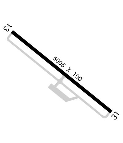
Runway Identifications
Runway Identification: 13/31Length: 5005 ft
Width: 100 ft
Surface: ASPHALT-FAIR CONDITION
Edge lights: Medium IntensityTreatment: NONE
| | Runway: 13 | | Runway: 31 |
| Mag heading: | 132° | Mag heading: | 312° |
| Rwy Slope: | .00% Down | Rwy Slope: | .00% Up |
| Approach: | | Approach: | |
| Pattern: | Left Traffic | Pattern: | Left Traffic |
| Markings: | NONPRECISION INSTRUMENT | Markings: | NONPRECISION INSTRUMENT |
| Marking Condition: | GOOD | Marking Condition: | GOOD |
| Arresting Dev: | | Arresting Dev: | |
| Lat & Long: | N3227.9 W08541.2 | Lat. & Long.: | N3227.4 W08540.4 |
| Elev: | 263.9 ft. MSL | Elev: | 263.8 ft. MSL |
| TCH: | 30 ft. AGL | TCH: | 30 ft. AGL |
| Visual Glide Path: | 3.00 degrees | Visual Glide Path: | 3.00 degrees |
| Displaced Threshold: | No | Displaced Threshold: | No |
| Touchdown Zone: | YES | Touchdown Zone: | YES |
| Touchdown Elev.: | 264.0 feet | Touchdown Elev.: | 264.0 feet |
| Visual Glide Slope: | 2-Light PAPI on LEFT side of Runway; OTS | Visual Glide Slope: | 2-Light PAPI on LEFT side of Runway; OTS |
| RVR Equipment: | | RVR Equipment: | |
| RVV Equipment: | NO | RVV Equipment: | NO |
| Approach Lights: | | Approach Lights: | |
| REIL: | NO | REIL: | NO |
| Centerline Lights: | NO | Centerline Lights: | NO |
| Touchdown lights: | NO | Touchdown lights: | NO |
| Runway Category: | Runway with a Non-precision Approach having visibility minimums greater than 3/4 mile | Runway Category: | Runway with a Non-precision Approach having visibility minimums greater than 3/4 mile |
| Declared Distances: | | Declared Distances: | |
| Obstructions: | BRUSH | Obstructions: | TREES |
| Marked: | NOT Marked/Lighted | Marked: | NOT Marked/Lighted |
| Clearance slope: | 18:1 | Clearance slope: | 8:1 |
| Obstruction height: | 77 feet AGL | Obstruction height: | 41 feet AGL |
| Dist. from runway: | 1646 feet | Dist. from runway: | 547 feet |
| Centerline offset: | 153 left of centerline | Centerline offset: | 273 feet right of centerline |
| Comments: | | Comments: | |

