Current Weather/Notams (Metars, TAFs, Notams, NWS Forecast, PIREPS, and nearby weather)
Customs Information Send updates to Support@FltPlan.com
Customs Not Available
Database effective 05/16/2024
Airport Diagram might not be current.
|
| Facility Name: | NEW TOWN MUNI |
| City Name: | NEW TOWN |
| County: | MOUNTRAIL |
| State abbrev: | ND |
| State Name: | NORTH DAKOTA |
| | |
| Ownership: | PUBLICLY OWNED |
| Use: | OPEN TO THE PUBLIC |
| Owner's Name: | NEW TOWN ARPT AUTH; APT CHAIRMAN MYLO WOLDING |
| Address: | 6031 16TH AVE SW |
| | MINOT, ND 58701 |
| Owner's Phone: | (701) 898-4918 |
| | |
| Manager's Name: | MYLO WOLDING |
| Address: | 3490 92ND AVE NW |
| | NEW TOWN, ND 58763 |
| Phone: | (701) 898-4918; ADDNAL CONTACT LONNY HAGEN AT 701-898-1150. |
| | |
| FAA Region: | GREAT LAKES |
| FAA Field Office: | DMA |
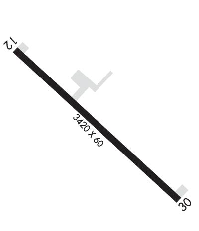
Runway Identifications
Runway Identification: 12/30Length: 3416 ft
Width: 60 ft
Surface: ASPHALT-GOOD CONDITION
Edge lights: Medium IntensityTreatment: NONE
| | Runway: 12 | | Runway: 30 |
| Mag heading: | 125° | Mag heading: | 305° |
| Rwy Slope: | .16% Up | Rwy Slope: | -.16% Down |
| Approach: | | Approach: | |
| Pattern: | Left Traffic | Pattern: | Left Traffic |
| Markings: | NONPRECISION INSTRUMENT | Markings: | NONPRECISION INSTRUMENT |
| Marking Condition: | GOOD | Marking Condition: | GOOD |
| Arresting Dev: | | Arresting Dev: | |
| Lat & Long: | N4758.3 W10229.0 | Lat. & Long.: | N4757.9 W10228.4 |
| Elev: | 1917.5 ft. MSL | Elev: | 1923.0 ft. MSL |
| TCH: | 40 ft. AGL | TCH: | 31 ft. AGL |
| Visual Glide Path: | 3.00 degrees | Visual Glide Path: | 3.00 degrees |
| Displaced Threshold: | No | Displaced Threshold: | 296 feet |
| Touchdown Zone: | YES | Touchdown Zone: | YES |
| Touchdown Elev.: | 1924.0 feet | Touchdown Elev.: | 1924.0 feet |
| Visual Glide Slope: | 2-Light PAPI on LEFT side of Runway | Visual Glide Slope: | 2-Light PAPI on LEFT side of Runway |
| RVR Equipment: | | RVR Equipment: | |
| RVV Equipment: | NO | RVV Equipment: | NO |
| Approach Lights: | | Approach Lights: | |
| REIL: | NO | REIL: | NO |
| Centerline Lights: | NO | Centerline Lights: | NO |
| Touchdown lights: | NO | Touchdown lights: | NO |
| Runway Category: | Runway with a Non-precision Approach | Runway Category: | Runway with a Non-precision Approach |
| Declared Distances: | | Declared Distances: | |
| Obstructions: | RR; ALSO +125 FT ELEVATORS 2800 FT FROM THR 1000 FT LEFT. | Obstructions: | ROAD |
| Marked: | NOT Marked/Lighted | Marked: | NOT Marked/Lighted |
| Clearance slope: | CTLG OBSTN EXCEEDS A 45 DEG SLP. | Clearance slope: | RWY 30 20:1 TO DSPLCD THR. |
| Obstruction height: | 12 feet AGL | Obstruction height: | 15 feet AGL |
| Dist. from runway: | 200 feet | Dist. from runway: | 200 feet |
| Centerline offset: | 210 left of centerline | Centerline offset: | 150 feet right of centerline |
| Comments: | 12 FT RR PRSNT RWY 12, 0 FT FROM CNTRLN; 220 FT L OF CNTRLN. | Comments: | |

