Current Weather/Notams (Metars, TAFs, Notams, NWS Forecast, PIREPS, and nearby weather)
Customs Information Send updates to Support@FltPlan.com
Customs Not Available
Database effective 05/16/2024
Airport Diagram might not be current.
|
| Facility Name: | FIELD OF DREAMS |
| City Name: | HINCKLEY |
| County: | PINE |
| State abbrev: | MN |
| State Name: | MINNESOTA |
| | |
| Ownership: | PRIVATELY OWNED |
| Use: | OPEN TO THE PUBLIC |
| Owner's Name: | BRIAN WEIDENDORF |
| Address: | 24226 LONE PINE ROAD |
| | HINCKLEY, MN 55051 |
| Owner's Phone: | 320-384-6667 |
| | |
| Manager's Name: | BRIAN WEIDENDORF |
| Address: | 24226 LONE PINE ROAD |
| | HINKLEY, MN 55051 |
| Phone: | 218-370-9704 |
| | |
| FAA Region: | GREAT LAKES |
| FAA Field Office: | DMA |
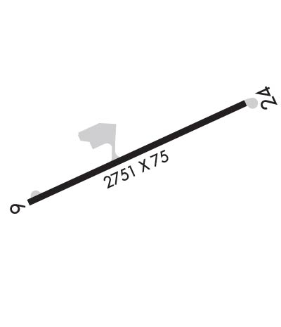
Runway Identifications
Runway Identification: 06/24Length: 2751 ft
Width: 75 ft
Surface: ASPHALT-FAIR CONDITION
Edge lights: Medium IntensityTreatment: NONE
| | Runway: 06 | | Runway: 24 |
| Mag heading: | 66° | Mag heading: | 246° |
| Rwy Slope: | -.42% Down | Rwy Slope: | .42% Up |
| Approach: | | Approach: | |
| Pattern: | Left Traffic | Pattern: | Left Traffic |
| Markings: | NONPRECISION INSTRUMENT | Markings: | NONPRECISION INSTRUMENT |
| Marking Condition: | POOR | Marking Condition: | POOR |
| Arresting Dev: | | Arresting Dev: | |
| Lat & Long: | N4601.3 W09254.0 | Lat. & Long.: | N4601.5 W09253.4 |
| Elev: | 1020.6 ft. MSL | Elev: | 1009.1 ft. MSL |
| TCH: | | TCH: | |
| Visual Glide Path: | | Visual Glide Path: | |
| Displaced Threshold: | 190 feet | Displaced Threshold: | 394 feet |
| Touchdown Zone: | YES | Touchdown Zone: | YES |
| Touchdown Elev.: | 1020.6 feet | Touchdown Elev.: | 1020.6 feet |
| Visual Glide Slope: | | Visual Glide Slope: | |
| RVR Equipment: | | RVR Equipment: | |
| RVV Equipment: | NO | RVV Equipment: | NO |
| Approach Lights: | | Approach Lights: | |
| REIL: | NO | REIL: | NO |
| Centerline Lights: | NO | Centerline Lights: | NO |
| Touchdown lights: | NO | Touchdown lights: | NO |
| Runway Category: | Runway with a Non-precision Approach | Runway Category: | Runway with a Visual Approach |
| Declared Distances: | | Declared Distances: | |
| Obstructions: | | Obstructions: | TREE |
| Marked: | | Marked: | NOT Marked/Lighted |
| Clearance slope: | 20:1 | Clearance slope: | 6:1 |
| Obstruction height: | | Obstruction height: | 65 feet AGL |
| Dist. from runway: | | Dist. from runway: | 616 feet |
| Centerline offset: | | Centerline offset: | 233 feet left of centerline |
| Comments: | +8 FT ROAD 35 FT FM RWY END L/R; +4 FT FENCE 63 FT FM RWY END L/R. | Comments: | |

