Click here for more info on on SMS!

K00C

ANIMAS AIR PARK
DURANGO
CO
Time Zone: Mountain
Lat: N 3712.2
Long: W 10752.2
Elev: 6684
Var: -12
Longest Runway: 5010
CTAF: 122.8

FBO & Flight Services info for K00C

FBOs: Update your Fuel Prices
Providing high quality fuel and services to you and your customers, from Phillips 66 Aviation.
Ph: 970-247-4632 Fax: 970-247-4676 Freq: 122.8WebsiteE-Mail
Service
Jet
100LL
SAF
MoGas
Fuel Avail: 8 AM - 5 PM
Full  6.00    Last Update: 04/08/2024 17:39

Self  5.75    
Misc. Info: Address: 163 FLIGHTLINE RD,   DURANGO, CO 81303

If you are an FBO, call 1-203-262-1700 to update your info or email: FltPlan.Advertising@garmin.com
Advertise your FBO on FltPlan.com

Runway & Approach Info for K00C
Rwy
Length
Land Dist**
Approach*
  Rwy
Length
Land Dist**
Approach*
01
5010x50  5010'          
 
  
19
  5010x50  5010'          
 
 * only ILS, LOC, LDA, and SDF approaches to a specific runway are shown
** For any Declared Landing Distance Available, please see A/FD or Approach plates
Runway Weight Capability (lbs.) Help
Runway IDSingle WheelDouble WheelDouble Tandem WheelDual Double Wheel
01/19N/AN/AN/AN/A
These numbers are Advisory and are not limits.   The Airport Manager should have more accurate Weight Limits
Approach Charts
FltPlan does not have IFR approach charts available for K00C.
Current Weather/Notams
Customs Information Send updates to Support@FltPlan.com
Customs Not Available
Database effective 05/16/2024
Airport Diagram of K00C
Airport Diagram might not be current.

Facility Name: ANIMAS AIR PARK
City Name: DURANGO
County: LA PLATA
State abbrev: CO
State Name: COLORADO
   
Ownership: PRIVATELY OWNED
Use: OPEN TO THE PUBLIC
Owner's Name: AIRPARK PROPERTY OWNERS ASSOC
Address: PO BOX 1797
 DURANGO, CO 81302
Owner's Phone: 970-247-4632
  
Manager's Name: DELVIN GREGG
Address: PO BOX 1797
 DURANGO, CO 81302
Phone: 970-247-4632
   
FAA Region: NORTHWEST MOUNTAIN
FAA Field Office: DEN


Sunrise / Sunset times for ANIMAS AIR PARK

DateSunriseSunset
04/24/24 Wednesday6:2419:55
04/25/24 Thursday6:2319:56
04/26/24 Friday6:2219:57
04/27/24 Saturday6:2019:58
04/28/24 Sunday6:1919:59
04/29/24 Monday6:1820:00
04/30/24 Tuesday6:1720:01
05/01/24 Wednesday6:1620:02
05/02/24 Thursday6:1520:03
05/03/24 Friday6:1420:03
05/04/24 Saturday6:1320:04
05/05/24 Sunday6:1220:05
05/06/24 Monday6:1120:06
05/07/24 Tuesday6:0920:07

Airport Facilities

Airport Attendance Schedule7 Days A Week DALGT
Airport Status OPERATIONAL (This Status can change at any time - please check NOTAMS)
Airport Lighting ScheduleACTVT MIRL RWY 01/19 - 122.9.
Airport Storage AvailableTie Downs, Hanger
Extra Services AvailableCrop Dusting, Air Ambulance, Cargo Handling, Charter, Flight Instruction, Aircraft Rental, Annual Surveying
Wind IndicatorYES - (unlit)
Control TowerNO
CTAF Frequency122.800
Unicom Frequency122.800
Rotating Beacon Color
Segmented CircleYES
Landing FeeNO

Airport Inspection Data

Airport InspectedSTATE - performed by STATE AERONAUTICAL PERSONNEL
Inspection Date06/21/2021

Airport Services

Type of Fuel AvailableGrade 100LL, JET A (freeze point -40C)
Airframe Repair ServiceMAJOR
Power Plant Repair ServiceMAJOR

Geographic Data

LatitudeN3712.2
LongitudeW10752.2 (ESTIMATED)
Arpt Elevation6684ft (SURVEYED)
Magnetic Variation12E
4 miles Sof DURANGO
Traffic Pattern Altitude
Sectional ChartDENVER

Aircraft Data

Operations (Reported)YearlyAvg. Daily
General Aviation Transient 367010
General Aviation Local 711820
Air Taxi 1620
Commerical 00
Commuter 00
Military 00
Aircraft based on Field
General Aviation Singles 44
General Aviation Multi 1
Jet Aircraft 0
General Aviation Helicopters 0
Military Aircraft 0
Gliders 0
Ultralights 0

FAA Services

FSS on field NO
FSS tie-in DENVER
FSS Phone 1-800-WX-BRIEF
Who issues Notams DEN
Notam D service at airport YES
ARTCC Name DENVER

Federal Status

Airport Certification
Aircraft Rescue & Firefighting IndexNone
Airport of EntryNo
Custom Landing RightsNo
Joint Civil/MilitaryNo
Military Landing rightsNo

Remarks

THIS AIRPORT HAS BEEN SURVEYED BY THE NATIONAL GEODETIC SURVEY.
CTN: HEL HOSP OPS 2.4 NM NE.
FOR CD CTC DENVER ARTCC AT 303-651-4257.
RWY 01/1 9 -1 TO - 2 FT DRAINAGE DITCHES 35 FT W & 30 FT E ALG CNTRLN; +4 FT FENCE 87 FT W ALG CNTRLN; +10 FT ROAD 105 FT W ALG CNTRLN.
RWY 01 200 FT DROPOFF 120 FT FM & PARALLEL THR; +15 FT TREES 1817 FT FM THR 105 FT L OF CNTRLN.
RWY 01/1 9 THR LGTS N END 162 FT FM PAVEMENT END.
Runway Identifications
Runway Identification: 01/19
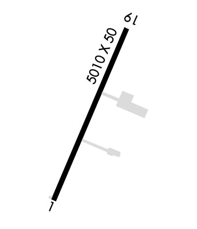
Length: 5010 ft
Width: 50 ft
Surface: ASPHALT-GOOD CONDITION
Edge lights: Medium Intensity

Treatment: NONE

 Runway: 01   Runway: 19
Mag heading: Mag heading: 189°
Rwy Slope: 1.14% UpRwy Slope: -1.14% Down
Approach: Approach:
Pattern: Right TrafficPattern: Left Traffic
Markings: BASICMarkings: BASIC
Marking Condition: FAIRMarking Condition: FAIR
Arresting Dev: Arresting Dev:
Lat & Long: N3711.8  W10752.3Lat. & Long.: N3712.6  W10752.0
Elev: 6626.8 ft. MSLElev: 6684.0 ft. MSL
TCH: TCH:
Visual Glide Path: Visual Glide Path:
Displaced Threshold: NoDisplaced Threshold: No
Touchdown Zone: YESTouchdown Zone: YES
Touchdown Elev.: 6650.5 feetTouchdown Elev.: 6684.0 feet
Visual Glide Slope: Visual Glide Slope:
RVR Equipment: RVR Equipment:
RVV Equipment: NORVV Equipment: NO
Approach Lights: Approach Lights:
REIL: NOREIL: NO
Centerline Lights: NOCenterline Lights: NO
Touchdown lights: NOTouchdown lights: NO
Runway Category: Runway with a Visual ApproachRunway Category: Runway with a Visual Approach
Declared Distances: Declared Distances:
Obstructions: Obstructions: BRUSH
Marked: Marked: NOT Marked/Lighted
Clearance slope: 50:1Clearance slope: 5:1
Obstruction height: Obstruction height: 20 feet AGL
Dist. from runway: Dist. from runway: 333 feet
Centerline offset: Centerline offset: 98 feet right of centerline
Comments: +32 FT HNGR 1495 FT FM THR 100 FT R OF CNTRLN.Comments: +10 FT ROAD AT THR 25 L OF CNTRLN; +16 FT TREE 116 FT FM THR 90 FT R OF CNTRLN; +11 FT TREE 41 FT FM THR 78 FT R OF CNTRLN; +9 FT TREE 73 FT FM THR 74 L OF CNTRLN.
C:/P: