
| ||||||
| ||||||
| ||||||
| ||||||
|
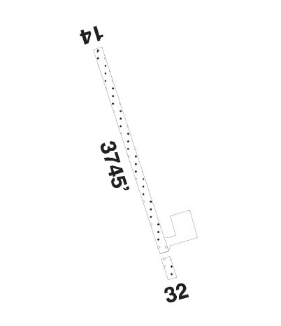
| Rwy | Rwy | |||||||
| 3745x100 | 3745' | 3745x100 | 3404' | |||||
| Runway ID | Single Wheel | Double Wheel | Double Tandem Wheel | Dual Double Wheel |
| 14/32 | N/A | N/A | N/A | N/A |
| These numbers are Advisory and are not limits. The Airport Manager should have more accurate Weight Limits | ||||
 Airport Diagram might not be current. | |
| Facility Name: | BEAVER CREEK |
| City Name: | BEAVER CREEK |
| County: | YUKON TERR, CANADA |
| State abbrev: | |
| State Name: | |
| Ownership: | PRIVATELY OWNED |
| Use: | OPEN TO THE PUBLIC |
| Owner's Name: | GOVT OF YUKON |
| Address: | |
| Owner's Phone: | 867-862-7282 |
| Manager's Name: | |
| Address: | |
| Phone: | |
| FAA Region: | |
| FAA Field Office: | NONE |
| Date | Sunrise | Sunset |
|---|---|---|
| 04/22/24 Monday | 7:33 | 23:12 |
| 04/23/24 Tuesday | 7:29 | 23:15 |
| 04/24/24 Wednesday | 7:26 | 23:18 |
| 04/25/24 Thursday | 7:23 | 23:21 |
| 04/26/24 Friday | 7:20 | 23:24 |
| 04/27/24 Saturday | 7:17 | 23:27 |
| 04/28/24 Sunday | 7:14 | 23:30 |
| 04/29/24 Monday | 7:10 | 23:32 |
| 04/30/24 Tuesday | 7:07 | 23:35 |
| 05/01/24 Wednesday | 7:04 | 23:38 |
| 05/02/24 Thursday | 7:01 | 23:41 |
| 05/03/24 Friday | 6:58 | 23:44 |
| 05/04/24 Saturday | 6:55 | 23:47 |
| 05/05/24 Sunday | 6:52 | 23:50 |
| Airport Attendance Schedule | |
| Airport Status | OPERATIONAL (This Status can change at any time - please check NOTAMS) |
| Airport Lighting Schedule | |
| Airport Storage Available | NONE |
| Extra Services Available | NONE |
| Wind Indicator | YES - (lighted) |
| Control Tower | NO |
| CTAF Frequency | |
| Unicom Frequency | |
| Rotating Beacon Color | W |
| Segmented Circle | NO |
| Landing Fee |
| Airport Inspected | No Inspection Data Available performed by the OWNER |
| Inspection Date | Unknown |
| Type of Fuel Available | None |
| Airframe Repair Service | None |
| Power Plant Repair Service | None |
| Latitude | N6224.6 |
| Longitude | W14052.1 (ESTIMATED) |
| Arpt Elevation | 2129ft (ESTIMATED) |
| Magnetic Variation | 25E |
| 1 miles NW | of BEAVER CREEK |
| Traffic Pattern Altitude | |
| Sectional Chart |
| Operations (Reported) | Yearly | Avg. Daily |
|---|---|---|
| General Aviation Transient | 0 | 0 |
| General Aviation Local | 0 | 0 |
| Air Taxi | 0 | 0 |
| Commerical | 0 | 0 |
| Commuter | 0 | 0 |
| Military | 0 | 0 |
| Aircraft based on Field | |
|---|---|
| General Aviation Singles | 0 |
| General Aviation Multi | 0 |
| Jet Aircraft | 0 |
| General Aviation Helicopters | 0 |
| Military Aircraft | 0 |
| Gliders | 0 |
| Ultralights | 0 |
| FSS on field | NO |
| FSS tie-in | WHITEHORSE |
| FSS Phone | |
| Who issues Notams | CYSQ |
| Notam D service at airport | No |
| ARTCC Name | EDMONTON |
| Airport Certification | |
| Aircraft Rescue & Firefighting Index | None |
| Airport of Entry | No |
| Custom Landing Rights | No |
| Joint Civil/Military | No |
| Military Landing rights | No |
| FOR ATTENDANCE SCHEDULE CALL 867-862-7282 OR 867-634-2035/2046. |
| Runway: 14 | Runway: 32 | ||
| Approach: | Approach: | ||
| Pattern: | Pattern: | ||
| Markings: | Markings: | ||
| Marking Condition: | Marking Condition: | ||
| Arresting Dev: | Arresting Dev: | ||
| Lat & Long: | Lat. & Long.: | ||
| Elev: | N/A | Elev: | N/A |
| TCH: | TCH: | ||
| Visual Glide Path: | 3.00 degrees | Visual Glide Path: | 3.00 degrees |
| Displaced Threshold: | No | Displaced Threshold: | 341 feet |
| Touchdown Zone: | NO | Touchdown Zone: | NO |
| Touchdown Elev.: | Touchdown Elev.: | ||
| Visual Glide Slope: | 2-Box VASI on LEFT side of Runway | Visual Glide Slope: | 2-Box VASI on LEFT side of Runway |
| RVR Equipment: | RVR Equipment: | ||
| RVV Equipment: | NO | RVV Equipment: | NO |
| Approach Lights: | Approach Lights: | ||
| REIL: | YES | REIL: | YES |
| Centerline Lights: | NO | Centerline Lights: | NO |
| Touchdown lights: | NO | Touchdown lights: | NO |
| Runway Category: | Runway Category: | ||
| Declared Distances: | TORA:3745' TODA:3945' ASDA:3745' LDA:3745' | Declared Distances: | TORA:3745' TODA:3945' ASDA:3745' LDA:3404' |
