Click here for more info on on SMS!

CYPT

PELEE ISLAND
PELEE ISLAND
ON
Time Zone: Eastern
Lat: N 4146.7
Long: W 08240.7
Elev: 571
Var: +07
Longest Runway: 3303
Clr Del: 216-898-2040
CTAF: 123.2

FBO & Flight Services info for CYPT

FBOs: Update your Fuel Prices

AIRPORTPh: 519-724-2931
-
Freq: 123.2
CUSTOMS AOE/15Ph: 888-226-7277
-
-
 
ARCAL LGTS TYPE K
-
Freq: 123.2  
If you are an FBO, call 1-203-262-1700 to update your info or email: FltPlan.Advertising@garmin.com
Advertise your FBO on FltPlan.com

Current Weather / Notams
Approach Charts for CYPT - PELEE ISLAND
Customs Information
Phone 888-226-7277
Fax N/A

Comments AOE/15 13-01Z Mon-Thu and Sat 13-04Z Fri and Sun May 1-Sep 14. 14-22Z dly Sep 15-Apr 30 PN
Runway & Approach Info for CYPT
Rwy
Length
Land Dist**
Approach*
  Rwy
Length
Land Dist**
Approach*
09
3300x75  3300'          
 
  
27
  3300x75  3300'          
 
18
1500x20  1500'          
 
  
36
  1500x20  1500'          
 
 * only ILS, LOC, LDA, and SDF approaches to a specific runway are shown
** For any Declared Landing Distance Available, please see A/FD or Approach plates
Runway Weight Capability (lbs.) Help
Runway IDSingle WheelDouble WheelDouble Tandem WheelDual Double Wheel
09/27N/AN/AN/AN/A
18/36N/AN/AN/AN/A
These numbers are Advisory and are not limits.   The Airport Manager should have more accurate Weight Limits
Approach Charts
Approaches    
Customs Information Send updates to Support@FltPlan.com
Phone 888-226-7277
Fax N/A

Comments AOE/15 13-01Z Mon-Thu and Sat 13-04Z Fri and Sun May 1-Sep 14. 14-22Z dly Sep 15-Apr 30 PN
A/FD
No A/FD Information
Database effective 05/16/2024
Airport Diagram of CYPT
Airport Diagram might not be current.

Facility Name: PELEE ISLAND
City Name: PELEE ISLAND
County: ONTARIO, CANADA
State abbrev:
State Name:
   
Ownership: PUBLICLY OWNED
Use: OPEN TO THE PUBLIC
Owner's Name:
Address:
 
Owner's Phone:
  
Manager's Name:
Address:
 
Phone:
   
FAA Region:
FAA Field Office: NONE


Sunrise / Sunset times for PELEE ISLAND

DateSunriseSunset
04/25/24 Thursday6:3420:23
04/26/24 Friday6:3320:24
04/27/24 Saturday6:3220:26
04/28/24 Sunday6:3020:27
04/29/24 Monday6:2920:28
04/30/24 Tuesday6:2720:29
05/01/24 Wednesday6:2620:30
05/02/24 Thursday6:2520:31
05/03/24 Friday6:2420:32
05/04/24 Saturday6:2220:33
05/05/24 Sunday6:2120:34
05/06/24 Monday6:2020:35
05/07/24 Tuesday6:1920:36
05/08/24 Wednesday6:1820:37

Airport Facilities

Airport Attendance Schedule
Airport Status OPERATIONAL (This Status can change at any time - please check NOTAMS)
Airport Lighting Schedule
Airport Storage AvailableNONE
Extra Services AvailableNONE
Wind IndicatorNONE
Control TowerNO
CTAF Frequency
Unicom Frequency
Rotating Beacon Color
Segmented CircleNO
Landing Fee

Airport Inspection Data

Airport InspectedNo Inspection Data Available performed by the OWNER
Inspection DateUnknown

Airport Services

Type of Fuel AvailableNone
Airframe Repair ServiceNone
Power Plant Repair ServiceNone

Geographic Data

LatitudeN4146.7
LongitudeW08240.7 (ESTIMATED)
Arpt Elevation571ft (ESTIMATED)
Magnetic Variation07W
0 miles of PELEE ISLAND
Traffic Pattern Altitude
Sectional Chart

Aircraft Data

Operations (Reported)YearlyAvg. Daily
General Aviation Transient 00
General Aviation Local 00
Air Taxi 00
Commerical 00
Commuter 00
Military 00
Aircraft based on Field
General Aviation Singles 0
General Aviation Multi 0
Jet Aircraft 0
General Aviation Helicopters 0
Military Aircraft 0
Gliders 0
Ultralights 0

FAA Services

FSS on field NO
FSS tie-in LONDON FIC
FSS Phone
Who issues Notams
Notam D service at airport No
ARTCC Name TORONTO

Federal Status

Airport Certification
Aircraft Rescue & Firefighting IndexNone
Airport of EntryNo
Custom Landing RightsNo
Joint Civil/MilitaryNo
Military Landing rightsNo
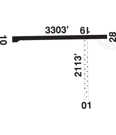
Runway Identifications
Runway Identification: 09/27
Length: 3300 ft
Width: 75 ft
Surface: ASPHALT
Edge lights:

Treatment: NONE

 Runway: 09   Runway: 27
Approach: Approach:
Pattern: Pattern:
Markings: Markings:
Marking Condition: Marking Condition:
Arresting Dev: Arresting Dev:
Lat & Long:   Lat. & Long.:   
Elev: N/AElev: N/A
TCH: TCH:
Visual Glide Path: Visual Glide Path:
Displaced Threshold: NoDisplaced Threshold: No
Touchdown Zone: NOTouchdown Zone: NO
Touchdown Elev.: Touchdown Elev.:
Visual Glide Slope: Visual Glide Slope:
RVR Equipment: RVR Equipment:
RVV Equipment: NORVV Equipment: NO
Approach Lights: Approach Lights:
REIL: NOREIL: NO
Centerline Lights: NOCenterline Lights: NO
Touchdown lights: NOTouchdown lights: NO
Runway Category: Runway Category:
Declared Distances: Declared Distances:
Runway Identification: 18/36
Length: 1500 ft
Width: 20 ft
Surface:
Edge lights:

Treatment: NONE

 Runway: 18   Runway: 36
Approach: Approach:
Pattern: Pattern:
Markings: Markings:
Marking Condition: Marking Condition:
Arresting Dev: Arresting Dev:
Lat & Long:   Lat. & Long.:   
Elev: N/AElev: N/A
TCH: TCH:
Visual Glide Path: Visual Glide Path:
Displaced Threshold: NoDisplaced Threshold: No
Touchdown Zone: NOTouchdown Zone: NO
Touchdown Elev.: Touchdown Elev.:
Visual Glide Slope: Visual Glide Slope:
RVR Equipment: RVR Equipment:
RVV Equipment: NORVV Equipment: NO
Approach Lights: Approach Lights:
REIL: NOREIL: NO
Centerline Lights: NOCenterline Lights: NO
Touchdown lights: NOTouchdown lights: NO
Runway Category: Runway Category:
Declared Distances: Declared Distances:
C:7/P: