Click here for more info on on SMS!

9TE2

JL BAR RANCH (PRIVATE)
SONORA
TX
Time Zone: Central
Lat: N 3034.1
Long: W 10026.7
Elev: 2344
Var: -05
Longest Runway: 5301
AWOS: 120.42

FBO & Flight Services info for 9TE2

FBOs: Update your Fuel Prices
Located on the western edge of the Texas Hill Country, The JL Bar Ranch & Resort Airport and full service FBO provides a gateway to the JL Bar Ranch, Resort and surrounding areas. Whether flying to the JL Bar Ranch or passing though on a midcontinent fuel stop, rest assured our professionally trained safety-first staff will exceed your expectations and make your visit a success.
Ph: 855-414-3337 Fax: 281-925-0551 Freq: 123.07WebsiteE-Mail
                     
Service
Jet
100LL
SAF
MoGas
Fuel Avail: PRIST+$0.05/gal 24 AVAILIBILITY WITH PRIOR ARRANGEMENTS
Full5.79      Last Update: 04/22/2024 15:33
PRICES GUARANTEED by FBO.
Self        
Misc. Info: VOLUME DISCOUNTS AVAILABLE, World Fuel CONTRACT FUEL, EPIC BRAVO POINTSAddress:

AWOSPh: 325-276-2771
-
Freq: 120.42  
If you are an FBO, call 1-203-262-1700 to update your info or email: FltPlan.Advertising@garmin.com
Advertise your FBO on FltPlan.com

Runway & Approach Info for 9TE2
Rwy
Length
Land Dist**
Approach*
  Rwy
Length
Land Dist**
Approach*
14
5301x80  5301'          
 
  
32
  5301x80  5301'          
 
 * only ILS, LOC, LDA, and SDF approaches to a specific runway are shown
** For any Declared Landing Distance Available, please see A/FD or Approach plates
Runway Weight Capability (lbs.) Help
Runway IDSingle WheelDouble WheelDouble Tandem WheelDual Double Wheel
14/32N/AN/AN/AN/A
These numbers are Advisory and are not limits.   The Airport Manager should have more accurate Weight Limits
Approach Charts
FltPlan does not have IFR approach charts available for 9TE2.
Current Weather/Notams
Customs Information Send updates to Support@FltPlan.com
Customs Not Available
A/FD
No A/FD Information
Database effective 05/16/2024
Airport Diagram of 9TE2
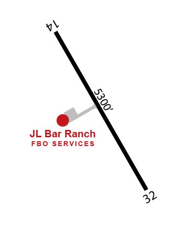
Airport Diagram might not be current.

Facility Name: JL BAR RANCH
City Name: SONORA
County: SUTTON
State abbrev: TX
State Name: TEXAS
   
Ownership: PRIVATELY OWNED
Use: PRIVATE
Owner's Name: JL BAR RANCH, LP
Address: 5106 KNICKERBOCKER ROAD
 SAN ANGELO, TX 76904
Owner's Phone: 325-942-8792
  
Manager's Name: JEFF WINKELMANN
Address: 5106 KNICKERBOCKER ROAD
 SAN ANGELO, TX 76904
Phone: 325-226-1644
   
FAA Region: SOUTHWEST
FAA Field Office: TEX


Sunrise / Sunset times for JL BAR RANCH

DateSunriseSunset
04/25/24 Thursday7:0320:17
04/26/24 Friday7:0220:17
04/27/24 Saturday7:0120:18
04/28/24 Sunday7:0020:19
04/29/24 Monday6:5920:19
04/30/24 Tuesday6:5820:20
05/01/24 Wednesday6:5720:21
05/02/24 Thursday6:5620:21
05/03/24 Friday6:5620:22
05/04/24 Saturday6:5520:23
05/05/24 Sunday6:5420:23
05/06/24 Monday6:5320:24
05/07/24 Tuesday6:5220:25
05/08/24 Wednesday6:5220:25

Airport Facilities

Airport Attendance ScheduleUNATTENDED
Airport Status OPERATIONAL (This Status can change at any time - please check NOTAMS)
Airport Lighting ScheduleACTVT MIRL RWY 14/32 - UNICOM.
Airport Storage AvailableNONE
Extra Services AvailableNONE
Wind IndicatorYES - (unlit)
Control TowerNO
CTAF Frequency
Unicom Frequency123.075
Rotating Beacon Color
Segmented CircleNO
Landing Fee

Airport Inspection Data

Airport Inspected5010-2 PRIVATE USE MAILOUT PROGRAM - performed by the OWNER
Inspection DateUnknown

Airport Services

Type of Fuel AvailableJET A (freeze point -40C); -A PPR - CTC ARPT MGR 325-226-1644.
Airframe Repair ServiceNone
Power Plant Repair ServiceNone

Geographic Data

LatitudeN3034.1
LongitudeW10026.7 (ESTIMATED)
Arpt Elevation2344ft (SURVEYED)
Magnetic Variation05E
12 miles Eof SONORA
Traffic Pattern Altitude
Sectional ChartSAN ANTONIO

Aircraft Data

Operations (Reported)YearlyAvg. Daily
General Aviation Transient 00
General Aviation Local 00
Air Taxi 00
Commerical 00
Commuter 00
Military 00
Aircraft based on Field
General Aviation Singles 0
General Aviation Multi 0
Jet Aircraft 1
General Aviation Helicopters 0
Military Aircraft 0
Gliders 0
Ultralights 0

FAA Services

FSS on field NO
FSS tie-in SAN ANGELO
FSS Phone 1-800-WX-BRIEF
Who issues Notams
Notam D service at airport No
ARTCC Name HOUSTON

Federal Status

Airport Certification
Aircraft Rescue & Firefighting IndexNone
Airport of EntryNo
Custom Landing RightsNo
Joint Civil/MilitaryNo
Military Landing rightsNo

Remarks

FOR CD CTC HOUSTON ARTCC AT 281-230-5622.
Runway Identifications
Runway Identification: 14/32
Length: 5301 ft
Width: 80 ft
Surface: ASPHALT-GOOD CONDITION
Edge lights: Medium Intensity

Treatment: NONE

 Runway: 14   Runway: 32
Mag heading: N/AMag heading: N/A
Rwy Slope: -.31% DownRwy Slope: .31% Up
Approach: Approach:
Pattern: Left TrafficPattern: Left Traffic
Markings: PRECISION INSTRUMENTMarkings: PRECISION INSTRUMENT
Marking Condition: GOODMarking Condition: GOOD
Arresting Dev: Arresting Dev:
Lat & Long: N3034.5  W10026.9Lat. & Long.: N3033.7  W10026.4
Elev: 2344.0 ft. MSLElev: 2327.4 ft. MSL
TCH: 40 ft. AGLTCH: 40 ft. AGL
Visual Glide Path: 3.00 degreesVisual Glide Path: 3.00 degrees
Displaced Threshold: NoDisplaced Threshold: No
Touchdown Zone: YESTouchdown Zone: YES
Touchdown Elev.: 2344.0 feetTouchdown Elev.: 2331.8 feet
Visual Glide Slope: 2-Light PAPI on LEFT side of RunwayVisual Glide Slope: 2-Light PAPI on LEFT side of Runway
RVR Equipment: RVR Equipment:
RVV Equipment: NORVV Equipment: NO
Approach Lights: Approach Lights:
REIL: NOREIL: NO
Centerline Lights: NOCenterline Lights: NO
Touchdown lights: NOTouchdown lights: NO
Runway Category: DRunway Category: D
Declared Distances: Declared Distances:
C:6/P: