Approach Charts
| FltPlan does not have IFR approach charts available for 9KY9. |
Current Weather/Notams (Metars, TAFs, Notams, NWS Forecast, PIREPS, and nearby weather)
Customs Information Send updates to Support@FltPlan.com
Customs Not Available
Database effective 05/16/2024
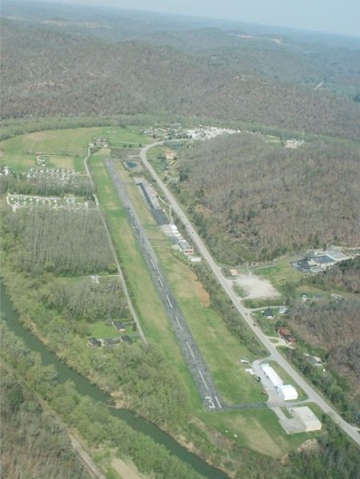
| Facility Name: | PAINTSVILLE-PRESTONSBURG-COMBS FLD |
| City Name: | PAINTSVILLE |
| County: | JOHNSON |
| State abbrev: | KY |
| State Name: | KENTUCKY |
| | |
| Ownership: | PUBLICLY OWNED |
| Use: | PRIVATE |
| Owner's Name: | PAINTSVILLE-PRESTONBURG AIR BOARD; AIR BOARD CHAIRMAN LARRY SHORT |
| Address: | 8315 KY ROUTE 321 |
| | HAGER HILL, KY 41222 |
| Owner's Phone: | 606-434-3640 |
| | |
| Manager's Name: | STANLEY HADDIX |
| Address: | 8315 KY ROUTE 321 |
| | HAGER HILL, KY 41222 |
| Phone: | (606) 434-5335 |
| | |
| FAA Region: | SOUTHERN |
| FAA Field Office: | MEM |
Runway Identifications
Runway Identification: 13/31Length: 3070 ft
Width: 75 ft
Surface: ASPHALT-GOOD CONDITION
Edge lights: Treatment: NONE
| | Runway: 13 | | Runway: 31 |
| Mag heading: | N/A | Mag heading: | N/A |
| Approach: | | Approach: | |
| Pattern: | Left Traffic | Pattern: | Left Traffic |
| Markings: | BASIC | Markings: | BASIC |
| Marking Condition: | GOOD | Marking Condition: | GOOD |
| Arresting Dev: | | Arresting Dev: | |
| Lat & Long: | | Lat. & Long.: | |
| Elev: | N/A | Elev: | N/A |
| TCH: | | TCH: | |
| Visual Glide Path: | | Visual Glide Path: | |
| Displaced Threshold: | No | Displaced Threshold: | No |
| Touchdown Zone: | NO | Touchdown Zone: | NO |
| Touchdown Elev.: | | Touchdown Elev.: | |
| Visual Glide Slope: | | Visual Glide Slope: | |
| RVR Equipment: | | RVR Equipment: | |
| RVV Equipment: | NO | RVV Equipment: | NO |
| Approach Lights: | | Approach Lights: | |
| REIL: | NO | REIL: | NO |
| Centerline Lights: | NO | Centerline Lights: | NO |
| Touchdown lights: | NO | Touchdown lights: | NO |
| Runway Category: | Runway with a Visual Approach | Runway Category: | Runway with a Visual Approach |
| Declared Distances: | | Declared Distances: | |
| Obstructions: | TREES; RY 13 HAS 300-500 FT HILLS 3000 FT FROM RY END. | Obstructions: | TREES |
| Marked: | NOT Marked/Lighted | Marked: | NOT Marked/Lighted |
| Clearance slope: | | Clearance slope: | 7:1 |
| Obstruction height: | 20 feet AGL | Obstruction height: | 57 feet AGL |
| Dist. from runway: | 200 feet | Dist. from runway: | 610 feet |
| Centerline offset: | 60 left of centerline | Centerline offset: | 84 feet left of centerline |
| Comments: | RY 13 20 FT TREES 150 FT FROM RY END & 60 FT LEFT. | Comments: | 12 FT TREES 150 FT FROM RY END & 45 FT LEFT. |