Click here for more info on on SMS!

5TX0

HIDDEN VALLEY AIRPARK (PRVT)
SHADY SHORES
TX
Time Zone: Central
Lat: N 3310.4
Long: W 09703.1
Elev: 611
Var: -07
Longest Runway: 2600
CTAF: 122.9

FBO & Flight Services info for 5TX0

FBOs: Update your Fuel Prices

AIRPORT (PVT)Ph: 940-321-2056
-
-
If you are an FBO, call 1-203-262-1700 to update your info or email: FltPlan.Advertising@garmin.com
Advertise your FBO on FltPlan.com

Runway & Approach Info for 5TX0
Rwy
Length
Land Dist**
Approach*
  Rwy
Length
Land Dist**
Approach*
17
2600x35  2600'          
 
  
35
  2600x35  2600'          
 
 * only ILS, LOC, LDA, and SDF approaches to a specific runway are shown
** For any Declared Landing Distance Available, please see A/FD or Approach plates
Runway Weight Capability (lbs.) Help
Runway IDSingle WheelDouble WheelDouble Tandem WheelDual Double Wheel
17/35N/AN/AN/AN/A
These numbers are Advisory and are not limits.   The Airport Manager should have more accurate Weight Limits
Approach Charts
FltPlan does not have IFR approach charts available for 5TX0.
Current Weather/Notams
Customs Information Send updates to Support@FltPlan.com
Customs Not Available
A/FD
No A/FD Information
Database effective 05/16/2024
Airport Diagram of 5TX0
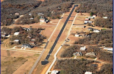
Airport Diagram might not be current.

Facility Name: HIDDEN VALLEY AIRPARK
City Name: SHADY SHORES
County: DENTON
State abbrev: TX
State Name: TEXAS
   
Ownership: PRIVATELY OWNED
Use: PRIVATE
Owner's Name: HIDDEN VALLEY HOA
Address: 99 HIDDEN VALLEY AIRPARK
 DENTON, TX 76208
Owner's Phone: 940-300-2443
  
Manager's Name: JOHN WATSON/DAVID VALDEZ
Address: 114 HIDDEN VALLEY AIRPARK
 DENTON, TX 76208
Phone: 940-300-2443; ASST MANAGER: 817-939-6400
   
FAA Region: SOUTHWEST
FAA Field Office: TEX


Sunrise / Sunset times for HIDDEN VALLEY AIRPARK

DateSunriseSunset
04/22/24 Monday6:4920:05
04/23/24 Tuesday6:4820:05
04/24/24 Wednesday6:4720:06
04/25/24 Thursday6:4620:07
04/26/24 Friday6:4520:08
04/27/24 Saturday6:4420:08
04/28/24 Sunday6:4320:09
04/29/24 Monday6:4220:10
04/30/24 Tuesday6:4120:10
05/01/24 Wednesday6:4020:11
05/02/24 Thursday6:3920:12
05/03/24 Friday6:3820:13
05/04/24 Saturday6:3720:13
05/05/24 Sunday6:3620:14

Airport Facilities

Airport Attendance ScheduleUNATTENDED
Airport Status OPERATIONAL (This Status can change at any time - please check NOTAMS)
Airport Lighting Schedule
Airport Storage AvailableNONE
Extra Services AvailableNONE
Wind IndicatorYES - (unlit)
Control TowerNO
CTAF Frequency122.900
Unicom Frequency
Rotating Beacon Color
Segmented CircleYES
Landing FeeNO

Airport Inspection Data

Airport Inspected5010-2 PRIVATE USE MAILOUT PROGRAM - performed by the OWNER
Inspection DateUnknown

Airport Services

Type of Fuel AvailableGrade 100LL; -10FUEL CO-OP MEMBERS ONLY
Airframe Repair ServiceNONE
Power Plant Repair ServiceNONE

Geographic Data

LatitudeN3310.4
LongitudeW09703.1 (ESTIMATED)
Arpt Elevation611ft (ESTIMATED)
Magnetic Variation07E
3 miles NWof SHADY SHORES
Traffic Pattern Altitude
Sectional ChartDALLAS-FT WORTH

Aircraft Data

Operations (Reported)YearlyAvg. Daily
General Aviation Transient 00
General Aviation Local 00
Air Taxi 00
Commerical 00
Commuter 00
Military 00
Aircraft based on Field
General Aviation Singles 69
General Aviation Multi 5
Jet Aircraft 0
General Aviation Helicopters 2
Military Aircraft 0
Gliders 0
Ultralights 0

FAA Services

FSS on field NO
FSS tie-in FORT WORTH
FSS Phone 1-800-WX-BRIEF
Who issues Notams
Notam D service at airport No
ARTCC Name FORT WORTH

Federal Status

Airport Certification
Aircraft Rescue & Firefighting IndexNone
Airport of EntryNo
Custom Landing RightsNo
Joint Civil/MilitaryNo
Military Landing rightsNo

Remarks

REMOTE CTL AIRFIELD AND REMOTE CTL OPS SOUTHWEST OF RWY END 35. REMOTE CTL PILOTS MNT UNICOM 122.9.
FOR CD CTC REGIONAL APCH AT 972-615-2799.
Runway Identifications
Runway Identification: 17/35
Length: 2600 ft
Width: 35 ft
Surface: ASPHALT
Edge lights:

Treatment: NONE

 Runway: 17   Runway: 35
Mag heading: N/AMag heading: N/A
Approach: Approach:
Pattern: Left TrafficPattern: Left Traffic
Markings: Markings:
Marking Condition: Marking Condition:
Arresting Dev: Arresting Dev:
Lat & Long:   Lat. & Long.:   
Elev: N/AElev: N/A
TCH: TCH:
Visual Glide Path: Visual Glide Path:
Displaced Threshold: NoDisplaced Threshold: No
Touchdown Zone: NOTouchdown Zone: NO
Touchdown Elev.: Touchdown Elev.:
Visual Glide Slope: Visual Glide Slope:
RVR Equipment: RVR Equipment:
RVV Equipment: NORVV Equipment: NO
Approach Lights: Approach Lights:
REIL: NOREIL: NO
Centerline Lights: NOCenterline Lights: NO
Touchdown lights: NOTouchdown lights: NO
Runway Category: Runway with a Visual ApproachRunway Category: Runway with a Visual Approach
Declared Distances: Declared Distances:
Obstructions: Obstructions: TREES
Marked: Marked: NOT Marked/Lighted
Clearance slope: Clearance slope:
Obstruction height: Obstruction height: 50 feet AGL
Dist. from runway: Dist. from runway: 2000 feet
Centerline offset: Centerline offset:
Comments: Comments:
C:/P: