
| GENERAL DOWNING - PEORIA INTL PEORIA IL |
| |
| Lat: N 4039.9 Long: W 08941.6 Elev: 661 Var: +02 Longest Runway: 10104 | ||
| Dept. ATIS: 126.1 Arr. ATIS: 126.1 Ground: 121.85 Tower: 124.0 | ||
| ||||||||||||||||||||||||||||||||||||||||||||||||||||||||||||||||||||
| ||||||||||||||||||||||||||||||||||||||||||||||||||||||||||||||||||||
| ||||||||||||||||||||||||||||||||||||||||||||||||||||||||||||||||||||
| Rwy | Rwy | |||||||
| 8004x150 | 8004' | 110.55 - 040° | 8004x150 | 8004' | ||||
| 10104x150 | 9604' | 109.90 - 128° | 10104x150 | 10104' | 109.90 - 308° | |||
| Runway ID | Single Wheel | Double Wheel | Double Tandem Wheel | Dual Double Wheel |
| 04/22 | 100,000 | 175,000 | 300,000 | N/A |
| 13/31 | 100,000 | 175,000 | 310,000 | N/A |
| These numbers are Advisory and are not limits. The Airport Manager should have more accurate Weight Limits | ||||
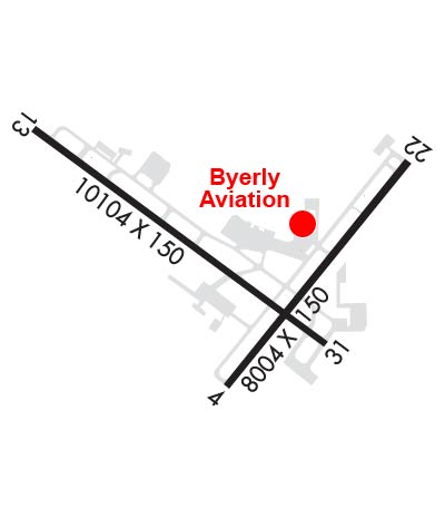 Airport Diagram might not be current. | |
| Facility Name: | GENERAL DOWNING - PEORIA INTL |
| City Name: | PEORIA |
| County: | PEORIA |
| State abbrev: | IL |
| State Name: | ILLINOIS |
| Ownership: | PUBLICLY OWNED |
| Use: | OPEN TO THE PUBLIC |
| Owner's Name: | METROPOLITAN ARPT AUTH OF PEORIA |
| Address: | 6100 WEST E.M. DIRKSEN PKWY |
| PEORIA, IL 61607 | |
| Owner's Phone: | 309-697-8272 |
| Manager's Name: | GENE OLSON |
| Address: | 6100 WEST E.M. DIRKSEN PKWY |
| PEORIA, IL 61607 | |
| Phone: | 309-697-8272; AIRPORT OPERATIONS 309-697-8272 X 110 |
| FAA Region: | GREAT LAKES |
| FAA Field Office: | CHI |
| Date | Sunrise | Sunset |
|---|---|---|
| 09/24/21 Friday | 6:48 | 18:53 |
| 09/25/21 Saturday | 6:49 | 18:51 |
| 09/26/21 Sunday | 6:50 | 18:50 |
| 09/27/21 Monday | 6:51 | 18:48 |
| 09/28/21 Tuesday | 6:52 | 18:46 |
| 09/29/21 Wednesday | 6:53 | 18:45 |
| 09/30/21 Thursday | 6:54 | 18:43 |
| 10/01/21 Friday | 6:55 | 18:41 |
| 10/02/21 Saturday | 6:56 | 18:40 |
| 10/03/21 Sunday | 6:57 | 18:38 |
| 10/04/21 Monday | 6:58 | 18:36 |
| 10/05/21 Tuesday | 6:59 | 18:35 |
| 10/06/21 Wednesday | 7:00 | 18:33 |
| 10/07/21 Thursday | 7:01 | 18:31 |
| Airport Attendance Schedule | CONTINUOUS |
| Airport Status | OPERATIONAL (This Status can change at any time - please check NOTAMS) |
| Airport Lighting Schedule | |
| Airport Storage Available | Tie Downs, Hanger |
| Extra Services Available | Charter, Flight Instruction, Aircraft Rental, Aircraft Sales |
| Wind Indicator | YES - (lighted) |
| Control Tower | YES |
| CTAF Frequency | |
| Unicom Frequency | 122.950 |
| Rotating Beacon Color | CLEAR-GREEN (Light Land Airport) |
| Segmented Circle | NO |
| Landing Fee | NO |
| Airport Inspected | FEDERAL - performed by FAA AIRPORTS FIELD PERSONNEL |
| Inspection Date | 06/18/2020 |
| Type of Fuel Available | Grade 100LL, JET A (freeze point -40C)A++ |
| Airframe Repair Service | MAJOR |
| Power Plant Repair Service | MAJOR |
| Latitude | N4039.9 |
| Longitude | W08941.6 (ESTIMATED) |
| Arpt Elevation | 660ft (SURVEYED) |
| Magnetic Variation | 02W |
| 4 miles W | of PEORIA |
| Traffic Pattern Altitude | |
| Sectional Chart | CHICAGO |
| Operations (Reported) | Yearly | Avg. Daily |
|---|---|---|
| General Aviation Transient | 9892 | 27 |
| General Aviation Local | 6884 | 19 |
| Air Taxi | 5474 | 15 |
| Commerical | 4388 | 12 |
| Commuter | 0 | 0 |
| Military | 6538 | 18 |
| Aircraft based on Field | |
|---|---|
| General Aviation Singles | 34 |
| General Aviation Multi | 6 |
| Jet Aircraft | 8 |
| General Aviation Helicopters | 3 |
| Military Aircraft | 14 |
| Gliders | 0 |
| Ultralights | 1 |
| FSS on field | NO |
| FSS tie-in | KANKAKEE |
| FSS Phone | 1-800-WX-BRIEF |
| Who issues Notams | PIA |
| Notam D service at airport | YES |
| ARTCC Name | CHICAGO |
| Airport Certification | AIRPORT RECEIVING SCHEDULED AIR CARRIER SERVICE FROM CARRIERS CERTIFICATED BY THE CIVIL AERONAUTICS BOARD |
| Aircraft Rescue & Firefighting Index | AIRPORT HAS A CERTIFICATE UNDER CFR PART 139 |
| Airport of Entry | No |
| Custom Landing Rights | YES |
| Joint Civil/Military | No |
| Military Landing rights | YES |
| NATIONAL PLAN OF INTEGRATED AIRPORT SYSTEMS (NPIAS) |
| GRANT AGREEMENTS UNDER FAAP/ADAP/AIP |
| ASSURANCES PURSUANT TO TITLE VI, CIVIL RIGHTS ACT OF 1964 |
| LGTD PLINE RWY 04 APCH. |
| BIRDS ON AND INVOF ARPT. |
| PORTION OF TWY A-5 NOT VISIBLE FROM TWR DUE TO A BLDG. |
| ANG: MILITARY AIRCRAFT CALL 'TORCH OPS' 20 MIN PRIOR TO LDG. |
Airport Communications & Frequencies:
| |||||||||||||||||||||||||||||||||||||||||||||||
| Runway: 04 | Runway: 22 | ||
| Mag heading: | 41° | Mag heading: | 221° |
| Rwy Slope: | .18% Up | Rwy Slope: | -.18% Down |
| Approach: | ILS/DME | Approach: | |
| Pattern: | Left Traffic | Pattern: | Left Traffic |
| Markings: | PRECISION INSTRUMENT | Markings: | PRECISION INSTRUMENT |
| Marking Condition: | FAIR | Marking Condition: | FAIR |
| Arresting Dev: | Arresting Dev: | ||
| Lat & Long: | N4039.2 W08941.7 | Lat. & Long.: | N4040.3 W08940.6 |
| Elev: | 642.5 ft. MSL | Elev: | 656.7 ft. MSL |
| TCH: | 54 ft. AGL | TCH: | 45 ft. AGL |
| Visual Glide Path: | 3.00 degrees | Visual Glide Path: | 3.00 degrees |
| Displaced Threshold: | No | Displaced Threshold: | No |
| Touchdown Zone: | YES | Touchdown Zone: | YES |
| Touchdown Elev.: | 652.1 feet | Touchdown Elev.: | 660.7 feet |
| Visual Glide Slope: | 4-Light PAPI on RIGHT side of Runway | Visual Glide Slope: | 4-Light PAPI on LEFT side of Runway; RWY 22 PAPI UNUSBL BYD 9 DEGS RIGHT OF CNTRLN. |
| RVR Equipment: | TOUCHDOWN-ROLLOUT | RVR Equipment: | |
| RVV Equipment: | NO | RVV Equipment: | NO |
| Approach Lights: | MALSR - 1,400 foot medium intensity approach lighting system with runway alignment indicator lights | Approach Lights: | |
| REIL: | NO | REIL: | NO |
| Centerline Lights: | NO | Centerline Lights: | NO |
| Touchdown lights: | NO | Touchdown lights: | NO |
| Runway Category: | Precision Instrument Runway | Runway Category: | Runway with a Non-precision Approach having visibility minimums greater than 3/4 mile |
| Declared Distances: | TORA:8004' TODA:8004' ASDA:7826' LDA:7826' | Declared Distances: | TORA:8004' TODA:8004' ASDA:8004' LDA:8004' |
| Obstructions: | TREE | Obstructions: | TREE |
| Marked: | NOT Marked/Lighted | Marked: | NOT Marked/Lighted |
| Clearance slope: | 46:1 | Clearance slope: | 24:1 |
| Obstruction height: | 135 feet AGL | Obstruction height: | 93 feet AGL |
| Dist. from runway: | 6500 feet | Dist. from runway: | 2500 feet |
| Centerline offset: | 430 left of centerline | Centerline offset: | 50B |
| Comments: | Comments: |
| Runway: 13 | Runway: 31 | ||
| Mag heading: | 129° | Mag heading: | 309° |
| Rwy Slope: | .06% Up | Rwy Slope: | -.06% Down |
| Approach: | ILS | Approach: | ILS |
| Pattern: | Left Traffic | Pattern: | Left Traffic |
| Markings: | PRECISION INSTRUMENT | Markings: | PRECISION INSTRUMENT |
| Marking Condition: | GOOD | Marking Condition: | GOOD |
| Arresting Dev: | Arresting Dev: | ||
| Lat & Long: | N4040.4 W08942.8 | Lat. & Long.: | N4039.4 W08941.1 |
| Elev: | 635.7 ft. MSL | Elev: | 642.2 ft. MSL |
| TCH: | 57 ft. AGL | TCH: | |
| Visual Glide Path: | 3.00 degrees | Visual Glide Path: | |
| Displaced Threshold: | 500 feet | Displaced Threshold: | No |
| Touchdown Zone: | YES | Touchdown Zone: | YES |
| Touchdown Elev.: | 631.8 feet | Touchdown Elev.: | 650.3 feet |
| Visual Glide Slope: | 4-Light PAPI on RIGHT side of Runway | Visual Glide Slope: | |
| RVR Equipment: | ROLLOUT | RVR Equipment: | TOUCHDOWN |
| RVV Equipment: | NO | RVV Equipment: | YES |
| Approach Lights: | MALSR - 1,400 foot medium intensity approach lighting system with runway alignment indicator lights | Approach Lights: | MALSR - 1,400 foot medium intensity approach lighting system with runway alignment indicator lights |
| REIL: | NO | REIL: | NO |
| Centerline Lights: | NO | Centerline Lights: | NO |
| Touchdown lights: | NO | Touchdown lights: | NO |
| Runway Category: | Precision Instrument Runway | Runway Category: | Precision Instrument Runway |
| Declared Distances: | TORA:10104' TODA:10104' ASDA:9604' LDA:9604' | Declared Distances: | TORA:10104' TODA:10104' ASDA:10104' LDA:10104' |
| Obstructions: | TREE | Obstructions: | TREE |
| Marked: | NOT Marked/Lighted | Marked: | NOT Marked/Lighted |
| Clearance slope: | 35:1; APCH SLOPE 36:1 TO DSPLCD THLD. | Clearance slope: | 44:1 |
| Obstruction height: | 137 feet AGL | Obstruction height: | 79 feet AGL |
| Dist. from runway: | 5034 feet | Dist. from runway: | 3695 feet |
| Centerline offset: | 254 left of centerline | Centerline offset: | 458 feet right of centerline |
| Comments: | Comments: |
Thanks for using FltPlan.com
all rights reserved © 1999-2021 by Flight Plan LLC