
| COASTAL CAROLINA REGIONAL NEW BERN NC |
| |
| Lat: N 3504.4 Long: W 07702.6 Elev: 18.0 Var: +08 Longest Runway: 6452 | ||
| Clr Del: 120.52 TW CLD AWOS: 118.52 Ground: 121.7 Tower: 124.25 | ||
| ||||||
| ||||||
|
| Rwy | Rwy | |||||||
| 6452x150 | 6153' | 110.50 - 038° | 6452x150 | 6452' | ||||
| 4001x150 | 4001' | 4001x150 | 4001' | |||||
| Runway ID | Single Wheel | Double Wheel | Double Tandem Wheel | Dual Double Wheel |
| 04/22 | 80,000 | 123,000 | N/A | N/A |
| 14/32 | 28,000 | 45,000 | N/A | N/A |
| These numbers are Advisory and are not limits. The Airport Manager should have more accurate Weight Limits | ||||
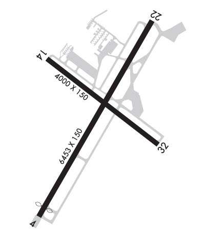 Airport Diagram might not be current. | |
| Facility Name: | COASTAL CAROLINA RGNL |
| City Name: | NEW BERN |
| County: | CRAVEN |
| State abbrev: | NC |
| State Name: | NORTH CAROLINA |
| Ownership: | PUBLICLY OWNED |
| Use: | OPEN TO THE PUBLIC |
| Owner's Name: | CRAVEN COUNTY |
| Address: | PO BOX 3258 |
| NEW BERN, NC 28560 | |
| Owner's Phone: | 252-638-8591 |
| Manager's Name: | ANDREW SHORTER |
| Address: | 200 TERMINAL DRIVE |
| NEW BERN, NC 28562-6455 | |
| Phone: | 252-638-8591 |
| FAA Region: | SOUTHERN |
| FAA Field Office: | MEM |
| Date | Sunrise | Sunset |
|---|---|---|
| 09/24/21 Friday | 6:57 | 19:02 |
| 09/25/21 Saturday | 6:58 | 19:01 |
| 09/26/21 Sunday | 6:59 | 19:00 |
| 09/27/21 Monday | 7:00 | 18:58 |
| 09/28/21 Tuesday | 7:00 | 18:57 |
| 09/29/21 Wednesday | 7:01 | 18:55 |
| 09/30/21 Thursday | 7:02 | 18:54 |
| 10/01/21 Friday | 7:03 | 18:52 |
| 10/02/21 Saturday | 7:03 | 18:51 |
| 10/03/21 Sunday | 7:04 | 18:50 |
| 10/04/21 Monday | 7:05 | 18:48 |
| 10/05/21 Tuesday | 7:06 | 18:47 |
| 10/06/21 Wednesday | 7:07 | 18:45 |
| 10/07/21 Thursday | 7:07 | 18:44 |
| Airport Attendance Schedule | 7 Days A Week 0500-2330 |
| Airport Status | OPERATIONAL (This Status can change at any time - please check NOTAMS) |
| Airport Lighting Schedule | ACTVT REIL RWY 04, 22, 14 & 32; HIRL 04/22, MIRL 14/32 - CTAF. PAPI RWY 04, 22, 14 & 32 OPER CONTINUOUSLY. |
| Airport Storage Available | Tie Downs, Hanger |
| Extra Services Available | Air Freight, Cargo Handling, Charter, Flight Instruction, Aircraft Rental |
| Wind Indicator | YES - (lighted) |
| Control Tower | YES |
| CTAF Frequency | 124.250 |
| Unicom Frequency | |
| Rotating Beacon Color | CLEAR-GREEN (Light Land Airport) |
| Segmented Circle | NO |
| Landing Fee | NO |
| Airport Inspected | FEDERAL - performed by FAA AIRPORTS FIELD PERSONNEL |
| Inspection Date | 06/15/2020 |
| Type of Fuel Available | Grade 100LL, JET A (freeze point -40C) |
| Airframe Repair Service | MAJOR |
| Power Plant Repair Service | MAJOR |
| Latitude | N3504.4 |
| Longitude | W07702.6 (ESTIMATED) |
| Arpt Elevation | 17ft (SURVEYED) |
| Magnetic Variation | 08W |
| 3 miles SE | of NEW BERN |
| Traffic Pattern Altitude | |
| Sectional Chart | CHARLOTTE |
| Operations (Reported) | Yearly | Avg. Daily |
|---|---|---|
| General Aviation Transient | 16767 | 46 |
| General Aviation Local | 20492 | 56 |
| Air Taxi | 2889 | 8 |
| Commerical | 5795 | 16 |
| Commuter | 0 | 0 |
| Military | 1370 | 4 |
| Aircraft based on Field | |
|---|---|
| General Aviation Singles | 73 |
| General Aviation Multi | 5 |
| Jet Aircraft | 3 |
| General Aviation Helicopters | 2 |
| Military Aircraft | 0 |
| Gliders | 0 |
| Ultralights | 0 |
| FSS on field | NO |
| FSS tie-in | RALEIGH |
| FSS Phone | 1-800-WX-BRIEF |
| Who issues Notams | EWN |
| Notam D service at airport | YES |
| ARTCC Name | WASHINGTON |
| Airport Certification | AIRPORT RECEIVING SCHEDULED AIR CARRIER SERVICE FROM CARRIERS CERTIFICATED BY THE CIVIL AERONAUTICS BOARD; CLSD TO UNSKED ACR OPNS WITH MORE THAN 30 PSGR SEATS EXCP 24 HR PPR CALL AMGR 252-638-8591. |
| Aircraft Rescue & Firefighting Index | AIRPORT HAS A CERTIFICATE UNDER CFR PART 139 |
| Airport of Entry | No |
| Custom Landing Rights | No |
| Joint Civil/Military | No |
| Military Landing rights | YES |
| NATIONAL PLAN OF INTEGRATED AIRPORT SYSTEMS (NPIAS) |
| GRANT AGREEMENTS UNDER FAAP/ADAP/AIP |
| ASSURANCES PURSUANT TO TITLE VI, CIVIL RIGHTS ACT OF 1964 |
| AGREEMENT UNDER DLAND OR DCLA HAS EXPIRED. |
| MIL TACTICAL JET ACFT; STRAIGHT IN, FULL STOP LDGS ONLY; RWY 14/32 FOR EUO. |
| RWY14/32 AND ASSOCIATED TWYS NOT AVBL FOR SCHEDULED ACR OPNS WITH MORE THAN 9 PSGR SEATS OR UNSCHEDULED ACR AT LEAST 31 PSGR SEATS. |
Airport Communications & Frequencies:
| |||||||||||||||||||||||||||||
| Runway: 04 | Runway: 22 | ||
| Mag heading: | 39° | Mag heading: | 219° |
| Rwy Slope: | .02% Up | Rwy Slope: | -.02% Down |
| Approach: | ILS | Approach: | |
| Pattern: | Left Traffic | Pattern: | Left Traffic |
| Markings: | PRECISION INSTRUMENT | Markings: | PRECISION INSTRUMENT |
| Marking Condition: | POOR; RWY 04 & 22 MARKINGS FADED. | Marking Condition: | POOR |
| Arresting Dev: | Arresting Dev: | EMAS; ARRESTING GEAR/SYSTEM: ENGINEERED MATERIALS ARRESTING SYSTEM (EMAS) 279.42 FT IN LENGTH BY 162 FT IN WIDTH LOCATED AT THE DEPARTURE END OF RWY 22. | |
| Lat & Long: | N3503.9 W07702.9 | Lat. & Long.: | N3504.8 W07702.3 |
| Elev: | 13.4 ft. MSL | Elev: | 14.5 ft. MSL |
| TCH: | 50 ft. AGL | TCH: | 31 ft. AGL |
| Visual Glide Path: | 3.00 degrees | Visual Glide Path: | 3.00 degrees |
| Displaced Threshold: | 299 feet | Displaced Threshold: | No |
| Touchdown Zone: | YES | Touchdown Zone: | YES |
| Touchdown Elev.: | 16.7 feet | Touchdown Elev.: | 16.7 feet |
| Visual Glide Slope: | 4-Light PAPI on LEFT side of Runway | Visual Glide Slope: | 4-Light PAPI on LEFT side of Runway |
| RVR Equipment: | RVR Equipment: | ||
| RVV Equipment: | NO | RVV Equipment: | NO |
| Approach Lights: | Approach Lights: | ||
| REIL: | YES | REIL: | YES |
| Centerline Lights: | NO | Centerline Lights: | NO |
| Touchdown lights: | NO | Touchdown lights: | NO |
| Runway Category: | Precision Instrument Runway | Runway Category: | Runway with a Non-precision Approach having visibility minimums greater than 3/4 mile |
| Declared Distances: | TORA:6453' TODA:6453' ASDA:6053' LDA:5753' | Declared Distances: | TORA:6453' TODA:6453' ASDA:6153' LDA:6153' |
| Obstructions: | Obstructions: | TREES | |
| Marked: | Marked: | NOT Marked/Lighted | |
| Clearance slope: | 50:1 | Clearance slope: | 34:1 |
| Obstruction height: | Obstruction height: | 68 feet AGL | |
| Dist. from runway: | Dist. from runway: | 2543 feet | |
| Centerline offset: | Centerline offset: | 558 feet left of centerline | |
| Comments: | Comments: |
| Runway: 14 | Runway: 32 | ||
| Mag heading: | 136° | Mag heading: | 316° |
| Rwy Slope: | .15% Up | Rwy Slope: | -.15% Down |
| Approach: | Approach: | ||
| Pattern: | Left Traffic | Pattern: | Left Traffic |
| Markings: | NONPRECISION INSTRUMENT | Markings: | NONPRECISION INSTRUMENT |
| Marking Condition: | GOOD | Marking Condition: | GOOD |
| Arresting Dev: | Arresting Dev: | ||
| Lat & Long: | N3504.6 W07702.9 | Lat. & Long.: | N3504.2 W07702.2 |
| Elev: | 11.6 ft. MSL | Elev: | 17.6 ft. MSL |
| TCH: | 39 ft. AGL | TCH: | 29 ft. AGL |
| Visual Glide Path: | 4.00 degrees | Visual Glide Path: | 3.00 degrees |
| Displaced Threshold: | No | Displaced Threshold: | No |
| Touchdown Zone: | YES | Touchdown Zone: | YES |
| Touchdown Elev.: | 17.2 feet | Touchdown Elev.: | 17.9 feet |
| Visual Glide Slope: | 2-Light PAPI on LEFT side of Runway | Visual Glide Slope: | 2-Light PAPI on LEFT side of Runway |
| RVR Equipment: | RVR Equipment: | ||
| RVV Equipment: | NO | RVV Equipment: | NO |
| Approach Lights: | Approach Lights: | ||
| REIL: | YES | REIL: | YES |
| Centerline Lights: | NO | Centerline Lights: | NO |
| Touchdown lights: | NO | Touchdown lights: | NO |
| Runway Category: | Runway with a Visual Approach | Runway Category: | Runway with a Visual Approach |
| Declared Distances: | Declared Distances: | ||
| Obstructions: | TREES | Obstructions: | TREE |
| Marked: | NOT Marked/Lighted | Marked: | NOT Marked/Lighted |
| Clearance slope: | 20:1 | Clearance slope: | 25:1 |
| Obstruction height: | 28 feet AGL | Obstruction height: | 26 feet AGL |
| Dist. from runway: | 1000 feet | Dist. from runway: | 862 feet |
| Centerline offset: | 500 right of centerline | Centerline offset: | 80 feet left of centerline |
| Comments: | Comments: |
Thanks for using FltPlan.com
all rights reserved © 1999-2021 by Flight Plan LLC
