
| ZEPHYRHILLS MUNI ZEPHYRHILLS FL |
| |
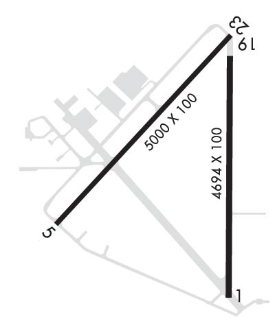
| Lat: N 2813.7 Long: W 08209.4 Elev: 90 Var: +06 Longest Runway: 5000 | ||
| AWOS: 118.97 CTAF: 123.07 | ||
| ||||||
| ||||||
|
| Rwy | Rwy | |||||||
| 4694x100 | 4388' | 4694x100 | 4694' | |||||
| 5000x100 | 5000' | 5000x100 | 5000' | |||||
| Runway ID | Single Wheel | Double Wheel | Double Tandem Wheel | Dual Double Wheel |
| 01/19 | 47,000 | 69,000 | N/A | N/A |
| 05/23 | 53,000 | 75,000 | N/A | N/A |
| These numbers are Advisory and are not limits. The Airport Manager should have more accurate Weight Limits | ||||
 Airport Diagram might not be current. | |
| Facility Name: | ZEPHYRHILLS MUNI |
| City Name: | ZEPHYRHILLS |
| County: | PASCO |
| State abbrev: | FL |
| State Name: | FLORIDA |
| Ownership: | PUBLICLY OWNED |
| Use: | OPEN TO THE PUBLIC |
| Owner's Name: | CITY OF ZEPHYRHILLS |
| Address: | 39450 SOUTH AVENUE |
| ZEPHYRHILLS, FL 33542 | |
| Owner's Phone: | 813-780-0030 |
| Manager's Name: | NATHAN COLEMAN |
| Address: | ZEPHYRHILLS MUNICIPAL AIRPORT, 39450 SOUTH AVENUE |
| ZEPHYRHILLS, FL 33542 | |
| Phone: | 813-780-0030 |
| FAA Region: | SOUTHERN |
| FAA Field Office: | ORL |

| Date | Sunrise | Sunset |
|---|---|---|
| 09/24/21 Friday | 7:18 | 19:23 |
| 09/25/21 Saturday | 7:18 | 19:22 |
| 09/26/21 Sunday | 7:19 | 19:21 |
| 09/27/21 Monday | 7:19 | 19:19 |
| 09/28/21 Tuesday | 7:20 | 19:18 |
| 09/29/21 Wednesday | 7:20 | 19:17 |
| 09/30/21 Thursday | 7:21 | 19:16 |
| 10/01/21 Friday | 7:21 | 19:15 |
| 10/02/21 Saturday | 7:22 | 19:14 |
| 10/03/21 Sunday | 7:22 | 19:13 |
| 10/04/21 Monday | 7:23 | 19:11 |
| 10/05/21 Tuesday | 7:23 | 19:10 |
| 10/06/21 Wednesday | 7:24 | 19:09 |
| 10/07/21 Thursday | 7:25 | 19:08 |
| Airport Attendance Schedule | 7 Days A Week 0800-1700 |
| Airport Status | OPERATIONAL (This Status can change at any time - please check NOTAMS) |
| Airport Lighting Schedule | ACTVT PAPI RWY 01, 05, 19 & 23; REIL RWY 1 & 19 - CTAF. HIRL RWY 1/19; MIRL RWY 5/23 PRESET TO LOW INTST DUSK-2200; INCR INTST & ACTVT AFT 2200 - CTAF. |
| Airport Storage Available | Tie Downs, Hanger |
| Extra Services Available | Glider, Flight Instruction, Parachute Jumping, Aircraft Rental, Glider Towing |
| Wind Indicator | YES - (lighted) |
| Control Tower | NO |
| CTAF Frequency | 123.075 |
| Unicom Frequency | 123.075 |
| Rotating Beacon Color | CLEAR-GREEN (Light Land Airport) |
| Segmented Circle | Y-L |
| Landing Fee | NO |
| Airport Inspected | STATE - performed by STATE AERONAUTICAL PERSONNEL |
| Inspection Date | 12/12/2017 |
| Type of Fuel Available | Grade 100LL, JET A (freeze point -40C), JET A; -10FUEL AVBL H24 WITH CREDIT CARD; AFT HR FUEL SVC - 813-714-6797. |
| Airframe Repair Service | MAJOR |
| Power Plant Repair Service | MAJOR |
| Latitude | N2813.7 |
| Longitude | W08209.4 (ESTIMATED) |
| Arpt Elevation | 89ft (SURVEYED) |
| Magnetic Variation | 06W |
| 1 miles SE | of ZEPHYRHILLS |
| Traffic Pattern Altitude | |
| Sectional Chart | JACKSONVILLE |
| Operations (Reported) | Yearly | Avg. Daily |
|---|---|---|
| General Aviation Transient | 16425 | 45 |
| General Aviation Local | 32850 | 90 |
| Air Taxi | 150 | 0 |
| Commerical | 0 | 0 |
| Commuter | 0 | 0 |
| Military | 0 | 0 |
| Aircraft based on Field | |
|---|---|
| General Aviation Singles | 101 |
| General Aviation Multi | 10 |
| Jet Aircraft | 1 |
| General Aviation Helicopters | 6 |
| Military Aircraft | 0 |
| Gliders | 0 |
| Ultralights | 1 |
| FSS on field | NO |
| FSS tie-in | SAINT PETERSBURG |
| FSS Phone | 1-800-WX-BRIEF |
| Who issues Notams | PIE |
| Notam D service at airport | YES |
| ARTCC Name | JACKSONVILLE |
| Airport Certification | |
| Aircraft Rescue & Firefighting Index | None |
| Airport of Entry | No |
| Custom Landing Rights | No |
| Joint Civil/Military | No |
| Military Landing rights | YES |
| NATIONAL PLAN OF INTEGRATED AIRPORT SYSTEMS (NPIAS) |
| GRANT AGREEMENTS UNDER FAAP/ADAP/AIP |
| SURPLUS PROPERTY AGREEMENT UNDER PUBLIC LAW 289 |
| SURPLUS PROPERTY AGREEMENT UNDER REGULATION 16-WAA |
| ASSURANCES PURSUANT TO TITLE VI, CIVIL RIGHTS ACT OF 1964 |
| AGREEMENT UNDER DLAND OR DCLA HAS EXPIRED. |
| 24 FT PLINE CROSSES APCH 800-1300 FT FROM RWY 23 END; MKD WITH RED FLAGS. |
| PATTERN ALTITUDE TWIN ENGINE 1500 FT AGL. |
| GLIDER OPS 6000 FT & BLW SR-SS. |
| SKY-DIVING ACFT DESCENDING FROM 13500 FT & ENTERING OPPOSITE TFC PAT FOR RWY 1/19 E OF ARPT. |
| PAEW ADJ TO RWYS & TWYS. |
| EXERCISE CAUTION; EXTENSIVE ACFT OPS ALL CATS & TYPES USING RWY 1/19; PARL TWY NOT AVBL. |
| NOISE SENSITIVE AREA NE & WEST OF ARPT; MNTN PAT ALTS & AVOID PWR CHG OVR RESIDENTAL AREAS. |
| FOR CD CTC TAMPA APCH AT 813-878-2528 OR 813-371-7745. |
Airport Communications & Frequencies:
| ||||||||||||||
| Runway: 01 | Runway: 19 | ||
| Mag heading: | 6° | Mag heading: | 186° |
| Rwy Slope: | .23% Up | Rwy Slope: | -.23% Down |
| Approach: | Approach: | ||
| Pattern: | Left Traffic | Pattern: | Right Traffic |
| Markings: | NONPRECISION INSTRUMENT | Markings: | NONPRECISION INSTRUMENT |
| Marking Condition: | FAIR | Marking Condition: | FAIR |
| Arresting Dev: | Arresting Dev: | ||
| Lat & Long: | N2813.2 W08209.2 | Lat. & Long.: | N2814.0 W08209.2 |
| Elev: | 78.6 ft. MSL | Elev: | 89.3 ft. MSL |
| TCH: | 42 ft. AGL | TCH: | 43 ft. AGL |
| Visual Glide Path: | 3.00 degrees | Visual Glide Path: | 3.00 degrees |
| Displaced Threshold: | 306 feet | Displaced Threshold: | No |
| Touchdown Zone: | YES | Touchdown Zone: | YES |
| Touchdown Elev.: | 86.6 feet | Touchdown Elev.: | 89.9 feet |
| Visual Glide Slope: | 4-Light PAPI on LEFT side of Runway | Visual Glide Slope: | 4-Light PAPI on LEFT side of Runway |
| RVR Equipment: | RVR Equipment: | ||
| RVV Equipment: | NO | RVV Equipment: | NO |
| Approach Lights: | Approach Lights: | ||
| REIL: | YES | REIL: | YES |
| Centerline Lights: | NO | Centerline Lights: | NO |
| Touchdown lights: | NO | Touchdown lights: | NO |
| Runway Category: | Runway with a Non-precision Approach | Runway Category: | Runway with a Non-precision Approach |
| Declared Distances: | TORA:4694' TODA:4694' ASDA:4694' LDA:4387' | Declared Distances: | TORA:4694' TODA:4694' ASDA:4694' LDA:4694' |
| Obstructions: | TREES | Obstructions: | TREE |
| Marked: | NOT Marked/Lighted | Marked: | NOT Marked/Lighted |
| Clearance slope: | 23:1; APCH SLOPE 34:1 TO DSPLCD THR. | Clearance slope: | 40:1 |
| Obstruction height: | 50 feet AGL | Obstruction height: | 60 feet AGL |
| Dist. from runway: | 1380 feet | Dist. from runway: | 2630 feet |
| Centerline offset: | 145 left of centerline | Centerline offset: | |
| Comments: | Comments: |
| Runway: 05 | Runway: 23 | ||
| Mag heading: | 49° | Mag heading: | 229° |
| Rwy Slope: | .05% Up | Rwy Slope: | -.05% Down |
| Approach: | Approach: | ||
| Pattern: | Left Traffic | Pattern: | Right Traffic |
| Markings: | NONPRECISION INSTRUMENT | Markings: | NONPRECISION INSTRUMENT |
| Marking Condition: | GOOD | Marking Condition: | GOOD |
| Arresting Dev: | Arresting Dev: | ||
| Lat & Long: | N2813.4 W08209.8 | Lat. & Long.: | N2814.1 W08209.2 |
| Elev: | 85.4 ft. MSL | Elev: | 87.9 ft. MSL |
| TCH: | 41 ft. AGL | TCH: | 41 ft. AGL |
| Visual Glide Path: | 3.63 degrees | Visual Glide Path: | 3.61 degrees |
| Displaced Threshold: | No | Displaced Threshold: | No |
| Touchdown Zone: | YES | Touchdown Zone: | YES |
| Touchdown Elev.: | 85.4 feet | Touchdown Elev.: | 88.1 feet |
| Visual Glide Slope: | 4-Light PAPI on LEFT side of Runway | Visual Glide Slope: | 4-Light PAPI on LEFT side of Runway |
| RVR Equipment: | RVR Equipment: | ||
| RVV Equipment: | NO | RVV Equipment: | NO |
| Approach Lights: | Approach Lights: | ||
| REIL: | NO | REIL: | NO |
| Centerline Lights: | NO | Centerline Lights: | NO |
| Touchdown lights: | NO | Touchdown lights: | NO |
| Runway Category: | Runway with a Non-precision Approach having visibility minimums greater than 3/4 mile | Runway Category: | Runway with a Non-precision Approach having visibility minimums greater than 3/4 mile |
| Declared Distances: | Declared Distances: | ||
| Obstructions: | TREE | Obstructions: | TREES |
| Marked: | NOT Marked/Lighted | Marked: | NOT Marked/Lighted |
| Clearance slope: | 34:1 | Clearance slope: | 29:1 |
| Obstruction height: | 48 feet AGL | Obstruction height: | 43 feet AGL |
| Dist. from runway: | 1850 feet | Dist. from runway: | 1485 feet |
| Centerline offset: | 205 right of centerline | Centerline offset: | 145 feet right of centerline |
| Comments: | Comments: |
Thanks for using FltPlan.com
all rights reserved © 1999-2021 by Flight Plan LLC