
| YOUNGSTOWN-WARREN RGNL YOUNGSTOWN/WARREN OH |
| |
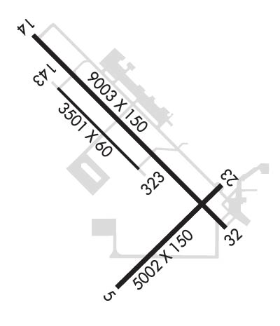
| Lat: N 4115.7 Long: W 08040.8 Elev: 1192 Var: +08 Longest Runway: 9003 | ||
| Clr Del: 118.25 Dept. ATIS: 123.75 Arr. ATIS: 123.75 Ground: 121.9 Tower: 119.5 | ||
| |||||||||||||||||||||||||||||||||||||||
| |||||||||||||||||||||||||||||||||||||||
| |||||||||||||||||||||||||||||||||||||||
| |||||||||||||||||||||||||||||||||||||||
| Rwy | Rwy | |||||||
| 5002x150 | 5002' | 5002x150 | 5002' | |||||
| 9003x150 | 9003' | 110.10 - 142° | 9003x150 | 9003' | 110.10 - 322° | |||
| 3501x60 | 3501' | 3501x60 | 3501' | |||||
| Runway ID | Single Wheel | Double Wheel | Double Tandem Wheel | Dual Double Wheel |
| 05/23 | 138,000 | 175,000 | 280,000 | N/A |
| 14/32 | N/A | N/A | N/A | N/A |
| 143/323 | N/A | N/A | N/A | N/A |
| These numbers are Advisory and are not limits. The Airport Manager should have more accurate Weight Limits | ||||
 Airport Diagram might not be current. | |
| Facility Name: | YOUNGSTOWN-WARREN RGNL |
| City Name: | YOUNGSTOWN/WARREN |
| County: | TRUMBULL |
| State abbrev: | OH |
| State Name: | OHIO |
| Ownership: | PUBLICLY OWNED |
| Use: | OPEN TO THE PUBLIC |
| Owner's Name: | WESTERN RESERVE PORT AUTHORITY |
| Address: | 1453 YOUNGSTOWN KINGSVILLE RD NE, STE 11 |
| VIENNA, OH 44473-9797 | |
| Owner's Phone: | 330-856-1537 |
| Manager's Name: | JOHN MOLITERNO |
| Address: | 1453 YOUNGSTOWN KINGSVILLE RD NE, STE 11 |
| VIENNA, OH 44473-9797 | |
| Phone: | 330-856-1537 |
| FAA Region: | GREAT LAKES |
| FAA Field Office: | DET |
| Date | Sunrise | Sunset |
|---|---|---|
| 09/24/21 Friday | 7:12 | 19:17 |
| 09/25/21 Saturday | 7:13 | 19:15 |
| 09/26/21 Sunday | 7:14 | 19:13 |
| 09/27/21 Monday | 7:15 | 19:12 |
| 09/28/21 Tuesday | 7:16 | 19:10 |
| 09/29/21 Wednesday | 7:17 | 19:08 |
| 09/30/21 Thursday | 7:18 | 19:07 |
| 10/01/21 Friday | 7:19 | 19:05 |
| 10/02/21 Saturday | 7:20 | 19:03 |
| 10/03/21 Sunday | 7:21 | 19:02 |
| 10/04/21 Monday | 7:22 | 19:00 |
| 10/05/21 Tuesday | 7:23 | 18:58 |
| 10/06/21 Wednesday | 7:24 | 18:57 |
| 10/07/21 Thursday | 7:25 | 18:55 |
| Airport Attendance Schedule | CONTINUOUS |
| Airport Status | OPERATIONAL (This Status can change at any time - please check NOTAMS) |
| Airport Lighting Schedule | |
| Airport Storage Available | Tie Downs, Hanger |
| Extra Services Available | Air Freight, Avionics, Cargo Handling, Charter, Flight Instruction, Aircraft Rental, Aircraft Sales |
| Wind Indicator | YES - (lighted) |
| Control Tower | YES |
| CTAF Frequency | |
| Unicom Frequency | 122.950 |
| Rotating Beacon Color | CLEAR-GREEN (Light Land Airport) |
| Segmented Circle | NO |
| Landing Fee | YES; LNDG FEE FOR ACFT OVER 5000 LBS GWT. |
| Airport Inspected | FEDERAL - performed by FAA AIRPORTS FIELD PERSONNEL |
| Inspection Date | 09/28/2018 |
| Type of Fuel Available | Grade 100LL, JET A (freeze point -40C) |
| Airframe Repair Service | MAJOR |
| Power Plant Repair Service | MAJOR |
| Latitude | N4115.7 |
| Longitude | W08040.8 (ESTIMATED) |
| Arpt Elevation | 1191ft (SURVEYED) |
| Magnetic Variation | 08W |
| 10 miles N | of YOUNGSTOWN/WARREN |
| Traffic Pattern Altitude | |
| Sectional Chart | DETROIT |
| Operations (Reported) | Yearly | Avg. Daily |
|---|---|---|
| General Aviation Transient | 11367 | 31 |
| General Aviation Local | 5206 | 14 |
| Air Taxi | 2582 | 7 |
| Commerical | 99 | 0 |
| Commuter | 0 | 0 |
| Military | 5775 | 16 |
| Aircraft based on Field | |
|---|---|
| General Aviation Singles | 0 |
| General Aviation Multi | 0 |
| Jet Aircraft | 0 |
| General Aviation Helicopters | 0 |
| Military Aircraft | 8 |
| Gliders | 0 |
| Ultralights | 0 |
| FSS on field | NO |
| FSS tie-in | CLEVELAND |
| FSS Phone | 1-800-WX-BRIEF |
| Who issues Notams | YNG |
| Notam D service at airport | YES |
| ARTCC Name | CLEVELAND |
| Airport Certification | CLSD TO SKEDD ACR OPS GTR THAN 9 PAX SEATS. 12 HRS PPR FOR UNSKED ACR OPS WITH MORE THAN 30 PAX SEATS CALL ARPT OPS MGR 330-609-5007. ARFF INDEX D AVBL 12 HRS PPR CTC 330-609-1369. |
| Aircraft Rescue & Firefighting Index | AIRPORT HAS A CERTIFICATE UNDER CFR PART 139 |
| Airport of Entry | No |
| Custom Landing Rights | No |
| Joint Civil/Military | No |
| Military Landing rights | YES |
| NATIONAL PLAN OF INTEGRATED AIRPORT SYSTEMS (NPIAS) |
| GRANT AGREEMENTS UNDER FAAP/ADAP/AIP |
| ASSURANCES PURSUANT TO TITLE VI, CIVIL RIGHTS ACT OF 1964 |
| AGREEMENT UNDER DLAND OR DCLA HAS EXPIRED. |
| TWY G EAST OF TWY H & TWY F NORTH OF RY 05/23 ARE CLSD. |
| RSTD: MIL LANDING ZONE 143*-323* FOR MIL USE ONLY. NO PRACTICE APCH 0300-1300Z++. AFRC ACFT OPR RSTD DUR BIRD WATCH CON MODERATE (TKOF OR LDG PERMS ONLY WHEN DEP AND ARR RTE AVOID IDENT BIRD ACT, NO LCL IFR/VFR TFC PAT ACT) AND SEVERE (TKOF AND LDG PROH WO OG/CC APVL). |
| MISC: FBO LINE SVC AVBL 1100-0400Z++, OT FONE C330-856-5000. |
| AFRC: PPR FOR RAMP AND MIL LZ CTC BASE OPS 1230-0400Z++ MON-FRI EXC HOL (DT 1130-0400Z) AND DUR UNIT TRNG SAT 1300-2200Z++ AND SUN 1200-2100Z++. FOR RAMP PPR PN48HRS CTC AFLD MGMT DSN 346-1069/1181, C330-609-1069/1181. AFLD MGMTAND MIL LZ 143/323 OPEN 1230-0400Z++ MON -FRI EXC HOL AND DUR UNIT TRNG SAT 1300-2200Z++ AND SUN 1200-2100Z++. |
| AFRC: NO TRANS ALERT SVC. INBD MIL ACFT INDICATE IN |
| AFRC: MIL LANDING ZONE 323 1.4% DOWNSLOPE. RY 143 1.4% UPSLOPE. SEE FLIP AP/1 SUPPLEMENTARY ARPT |
| FUEL: J8+100(MIL) J8(PN REQ) (NC-100LL,A). |
| FLUID: LOX (MIL). |
| OIL: O -156 |
| TERMINAL RAMP AND GENERAL AVIATION PARKING NOT VIS FR THE NW PORTION OF TWY H. MILITARY RAMP FOR MILITARY USE ONLY. |
| COMMERCIAL RAMP CLSD TO ALL GA TRAFFIC, COMMERCIAL BOUNDARY AREA DEFINED BY RED SFC PAINTED MARKING. |
| AMOPS DOES NOT ISSUE OR STOR COMSEC. LTD COMSEC STOR AVBL AT COMD POST, CTC DSN 346-1315, C330-609-1315 FOR PRIOR COORD. |
| FOR CD CTC YOUNGSTOWN APCH AT 330-856-4806, WHEN APCH CLSD CTC CLEVELAND ARTCC AT 440-774-0232. |
| AFRC: AIRCREWS - US CSTMS SVC NOT IMMED AVBL. ALL SUPPORT FOR CSTMS MUST BE PRE-COORD AT LEAST 72 HR IN ADVANCE WITH AFLD MGMT |
| TWY J ACFT TURN RADIUS RESTRICTION EXISTS FOR ACFT HAVING NOSE GEAR TO MAIN GEAR DIST GREATER THAN 64FT AND MAIN GEAR WID GREATER THAN 30FT |
| RSTD: ALL MIL ACFT OPR RSTD DRG BIRD WATCH CONDS, MODERATE (TKOF AND LNDG PMTD ONLY WHEN DEP/ARR RTE AVOID IDENT BIRD ACT, NON LCL IFR/VFR PAT ACT) AND SEVERE (TKOF AND LNDG PROHIBITED WO OG/CC APVL). |
| CAUTION: MIL CONDUCTING NVG OPS MON-FRI DUSK-0400++. |
| DEER & BIRD HAZARD. ALL MIL ACFT CTC VADER OPS FOR BIRD WATCH COND. |
| TWY 'T' W OF RY 5/23 CLSD INDEFLY. |
| RWY 143/ 323RWY USED AS A MILITARY ASSAULT STRIP. |
Airport Communications & Frequencies:
| |||||||||||||||||||||||||||||||||||||||
| Runway: 05 | Runway: 23 | ||
| Mag heading: | 53° | Mag heading: | 233° |
| Rwy Slope: | 1.37% Up | Rwy Slope: | -1.37% Down |
| Approach: | Approach: | ||
| Pattern: | Left Traffic | Pattern: | Left Traffic |
| Markings: | NONPRECISION INSTRUMENT | Markings: | NONPRECISION INSTRUMENT |
| Marking Condition: | GOOD | Marking Condition: | GOOD |
| Arresting Dev: | Arresting Dev: | ||
| Lat & Long: | N4115.0 W08040.9 | Lat. & Long.: | N4115.6 W08040.2 |
| Elev: | 1123.1 ft. MSL | Elev: | 1191.6 ft. MSL |
| TCH: | 51 ft. AGL | TCH: | 24 ft. AGL |
| Visual Glide Path: | 3.25 degrees | Visual Glide Path: | 3.00 degrees |
| Displaced Threshold: | No | Displaced Threshold: | No |
| Touchdown Zone: | YES | Touchdown Zone: | YES |
| Touchdown Elev.: | 1164.2 feet | Touchdown Elev.: | 1191.6 feet |
| Visual Glide Slope: | 4-BOX VASI ON LEFT SIDE OF RUNWAY | Visual Glide Slope: | 4-Light PAPI on RIGHT side of Runway; RWY 23 PAPI UNUSBL BYD 8 DEG LEFT OF RCL. |
| RVR Equipment: | RVR Equipment: | ||
| RVV Equipment: | NO | RVV Equipment: | NO |
| Approach Lights: | Approach Lights: | ||
| REIL: | YES | REIL: | YES |
| Centerline Lights: | NO | Centerline Lights: | NO |
| Touchdown lights: | NO | Touchdown lights: | NO |
| Runway Category: | Runway with a Visual Approach | Runway Category: | Runway with a Visual Approach |
| Declared Distances: | TORA:5002' TODA:5002' ASDA:5002' LDA:5002' | Declared Distances: | TORA:5002' TODA:5002' ASDA:5002' LDA:5002' |
| Obstructions: | TREES | Obstructions: | |
| Marked: | NOT Marked/Lighted | Marked: | |
| Clearance slope: | 16:1 | Clearance slope: | 50:1 |
| Obstruction height: | 94 feet AGL | Obstruction height: | |
| Dist. from runway: | 1749 feet | Dist. from runway: | |
| Centerline offset: | 398 left of centerline | Centerline offset: | |
| Comments: | Comments: |
| Runway: 14 | Runway: 32 | ||
| Mag heading: | 143° | Mag heading: | 323° |
| Rwy Slope: | .87% Up | Rwy Slope: | -.87% Down |
| Approach: | ILS | Approach: | ILS |
| Pattern: | Left Traffic | Pattern: | Left Traffic |
| Markings: | PRECISION INSTRUMENT | Markings: | PRECISION INSTRUMENT |
| Marking Condition: | GOOD | Marking Condition: | GOOD |
| Arresting Dev: | Arresting Dev: | ||
| Lat & Long: | N4116.4 W08041.5 | Lat. & Long.: | N4115.3 W08040.2 |
| Elev: | 1107.2 ft. MSL | Elev: | 1185.8 ft. MSL |
| TCH: | 57 ft. AGL | TCH: | 35 ft. AGL |
| Visual Glide Path: | 3.00 degrees | Visual Glide Path: | 3.00 degrees |
| Displaced Threshold: | No | Displaced Threshold: | No |
| Touchdown Zone: | YES | Touchdown Zone: | YES |
| Touchdown Elev.: | 1134.2 feet | Touchdown Elev.: | 1185.8 feet |
| Visual Glide Slope: | 4-Light PAPI on LEFT side of Runway | Visual Glide Slope: | 4-Light PAPI on LEFT side of Runway; UNUSBL BYD 8 DEGS RT OF CNTRLN. |
| RVR Equipment: | ROLLOUT | RVR Equipment: | TOUCHDOWN |
| RVV Equipment: | NO | RVV Equipment: | NO |
| Approach Lights: | MALSR - 1,400 foot medium intensity approach lighting system with runway alignment indicator lights | Approach Lights: | MALSR - 1,400 foot medium intensity approach lighting system with runway alignment indicator lights |
| REIL: | NO | REIL: | NO |
| Centerline Lights: | NO | Centerline Lights: | NO |
| Touchdown lights: | NO | Touchdown lights: | NO |
| Runway Category: | Precision Instrument Runway | Runway Category: | Precision Instrument Runway |
| Declared Distances: | TORA:9003' TODA:9003' ASDA:9003' LDA:9003' | Declared Distances: | TORA:9003' TODA:9003' ASDA:9003' LDA:9003' |
| Obstructions: | Obstructions: | TREES | |
| Marked: | Marked: | NOT Marked/Lighted | |
| Clearance slope: | 50:1 | Clearance slope: | 40:1 |
| Obstruction height: | Obstruction height: | 37 feet AGL | |
| Dist. from runway: | Dist. from runway: | 1689 feet | |
| Centerline offset: | Centerline offset: | 485 feet right of centerline | |
| Comments: | Comments: |
| Runway: 143 | Runway: 323 | ||
| Mag heading: | 143° | Mag heading: | 323° |
| Rwy Slope: | 1.35% Up | Rwy Slope: | -1.35% Down |
| Approach: | Approach: | ||
| Pattern: | Left Traffic | Pattern: | Left Traffic |
| Markings: | Markings: | ||
| Marking Condition: | Marking Condition: | ||
| Arresting Dev: | Arresting Dev: | ||
| Lat & Long: | N4116.1 W08041.4 | Lat. & Long.: | N4115.7 W08040.9 |
| Elev: | 1104.2 ft. MSL | Elev: | 1151.6 ft. MSL |
| TCH: | TCH: | ||
| Visual Glide Path: | Visual Glide Path: | ||
| Displaced Threshold: | No | Displaced Threshold: | No |
| Touchdown Zone: | YES | Touchdown Zone: | YES |
| Touchdown Elev.: | 1143.5 feet | Touchdown Elev.: | 1151.6 feet |
| Visual Glide Slope: | Visual Glide Slope: | ||
| RVR Equipment: | RVR Equipment: | ||
| RVV Equipment: | NO | RVV Equipment: | NO |
| Approach Lights: | Approach Lights: | ||
| REIL: | NO | REIL: | NO |
| Centerline Lights: | NO | Centerline Lights: | NO |
| Touchdown lights: | NO | Touchdown lights: | NO |
| Runway Category: | Runway with a Visual Approach | Runway Category: | Runway with a Visual Approach |
| Declared Distances: | TORA:3500' TODA:3500' ASDA:3500' LDA:3500' | Declared Distances: | TORA:3500' TODA:3500' ASDA:3500' LDA:3500' |
Thanks for using FltPlan.com
all rights reserved © 1999-2021 by Flight Plan LLC


