
| YAKIMA AIR TERMINAL/MCALLISTER YAKIMA WA |
| |
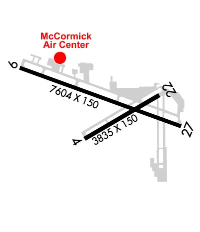
| Lat: N 4634.1 Long: W 12032.6 Elev: 1099 Var: -16 Longest Runway: 7604 | ||
| Clr Del: 121.9 Dept. ATIS: 125.25 Arr. ATIS: 125.25 Ground: 121.9 Tower: 133.25 | ||
| |||||||||||||||||||||||||||||||||||||||||||||||||||||||||||||||||||||
| |||||||||||||||||||||||||||||||||||||||||||||||||||||||||||||||||||||
| |||||||||||||||||||||||||||||||||||||||||||||||||||||||||||||||||||||
| |||||||||||||||||||||||||||||||||||||||||||||||||||||||||||||||||||||
| Rwy | Rwy | |||||||
| 3835x150 | 3835' | 3835x150 | 3835' | |||||
| 7604x150 | 7604' | 7604x150 | 7604' | 110.10 - 274° | ||||
| Runway ID | Single Wheel | Double Wheel | Double Tandem Wheel | Dual Double Wheel |
| 04/22 | 70,000 | 80,000 | 120,000 | N/A |
| 09/27 | 95,000 | 160,000 | 220,000 | 550,000 |
| These numbers are Advisory and are not limits. The Airport Manager should have more accurate Weight Limits | ||||
 Airport Diagram might not be current. | |
| Facility Name: | YAKIMA AIR TRML/MCALLISTER FLD |
| City Name: | YAKIMA |
| County: | YAKIMA |
| State abbrev: | WA |
| State Name: | WASHINGTON |
| Ownership: | PUBLICLY OWNED |
| Use: | OPEN TO THE PUBLIC |
| Owner's Name: | CITY OF YAKIMA |
| Address: | 2300 WEST WASHINGTON AVE |
| YAKIMA, WA 98903 | |
| Owner's Phone: | (509) 575-6149 |
| Manager's Name: | ROBERT HODGMAN |
| Address: | 2406 WEST WASHINGTON AVE, SUITE B |
| YAKIMA, WA 98903 | |
| Phone: | 509-575-6149 |
| FAA Region: | NORTHWEST MOUNTAIN |
| FAA Field Office: | SEA |
| Date | Sunrise | Sunset |
|---|---|---|
| 01/30/26 Friday | 7:29 | 17:03 |
| 01/31/26 Saturday | 7:27 | 17:05 |
| 02/01/26 Sunday | 7:26 | 17:06 |
| 02/02/26 Monday | 7:25 | 17:08 |
| 02/03/26 Tuesday | 7:24 | 17:09 |
| 02/04/26 Wednesday | 7:22 | 17:11 |
| 02/05/26 Thursday | 7:21 | 17:12 |
| 02/06/26 Friday | 7:20 | 17:14 |
| 02/07/26 Saturday | 7:18 | 17:15 |
| 02/08/26 Sunday | 7:17 | 17:17 |
| 02/09/26 Monday | 7:15 | 17:18 |
| 02/10/26 Tuesday | 7:14 | 17:20 |
| 02/11/26 Wednesday | 7:12 | 17:21 |
| 02/12/26 Thursday | 7:11 | 17:23 |
| Airport Attendance Schedule | 7 Days A Week 0600 - 2000 |
| Airport Status | OPERATIONAL (This Status can change at any time - please check NOTAMS) |
| Airport Lighting Schedule | WHEN ATCT CLSD ACTVT HIRL RY 09/27; MALSR RY 27 - CTAF. |
| Airport Storage Available | Tie Downs |
| Extra Services Available | Air Freight, Air Ambulance, Avionics, Charter, Flight Instruction, Aircraft Rental, Aircraft Sales |
| Wind Indicator | YES - (lighted) |
| Control Tower | YES |
| CTAF Frequency | 133.250 |
| Unicom Frequency | 122.950 |
| Rotating Beacon Color | WG |
| Segmented Circle | YES |
| Landing Fee | NO |
| Airport Inspected | FEDERAL - performed by FAA AIRPORTS FIELD PERSONNEL |
| Inspection Date | 02/12/2025 |
| Type of Fuel Available | Grade 100LL, JET A (freeze point -40C) |
| Airframe Repair Service | MAJOR |
| Power Plant Repair Service | MAJOR |
| Latitude | N4634.1 |
| Longitude | W12032.6 (ESTIMATED) |
| Arpt Elevation | 1098ft (SURVEYED) |
| Magnetic Variation | 16E |
| 3 miles S | of YAKIMA |
| Traffic Pattern Altitude | |
| Sectional Chart | SEATTLE |
| Operations (Reported) | Yearly | Avg. Daily |
|---|---|---|
| General Aviation Transient | 0 | 0 |
| General Aviation Local | 0 | 0 |
| Air Taxi | 0 | 0 |
| Commerical | 0 | 0 |
| Commuter | 0 | 0 |
| Military | 0 | 0 |
| Aircraft based on Field | |
|---|---|
| General Aviation Singles | 0 |
| General Aviation Multi | 0 |
| Jet Aircraft | 0 |
| General Aviation Helicopters | 0 |
| Military Aircraft | 0 |
| Gliders | 0 |
| Ultralights | 0 |
| FSS on field | NO |
| FSS tie-in | SEATTLE |
| FSS Phone | 1-800-WX-BRIEF |
| Who issues Notams | YKM |
| Notam D service at airport | YES |
| ARTCC Name | SEATTLE |
| Airport Certification | AIRPORT RECEIVING SCHEDULED AIR CARRIER SERVICE FROM CARRIERS CERTIFICATED BY THE CIVIL AERONAUTICS BOARD; PPR FOR UNSKED ACR OPNS WITH MORE THAN 30 PSGR SEATS CALL AMGR 509-575-6149/6150. |
| Aircraft Rescue & Firefighting Index | AIRPORT HAS A CERTIFICATE UNDER CFR PART 139 |
| Airport of Entry | No |
| Custom Landing Rights | No |
| Joint Civil/Military | No |
| Military Landing rights | YES |
| NATIONAL PLAN OF INTEGRATED AIRPORT SYSTEMS (NPIAS) |
| GRANT AGREEMENTS UNDER FAAP/ADAP/AIP |
| ASSURANCES PURSUANT TO TITLE VI, CIVIL RIGHTS ACT OF 1964 |
| AGREEMENT UNDER DLAND OR DCLA HAS EXPIRED. |
| RWY 4/22 MIRL, REILS AND PAPIS OTS WHEN TWR CLOSED. |
| TWY B1 AND TWY B2 TWY LIGHTS OTS WHEN TWR CLOSED. |
| TWY B LIGHTS SOUTH OF RWY 9/27 OTS WHEN TWR CLOSED. |
| REFLECTORS ON TWY C ONLY. |
| MAIN TERMINAL RAMP RESTRICTED TO AIR CARRIER AIRCRAFT ONLY. RESTRICTED AREA OUTLINED WITH RED MARKINGS. |
| FOR CD IF UNA TO CTC ON FSS FREQ, CTC SEATTLE ARTCC AT 253-351-3694. |
| SURF CONDS UNMON 2400-0500L |
| BE ALERT: BIRDS IN VICINTY OF YAKIMA RIVER 5 NM E OF APCH TO 27. |
| TWY B FM APCH END OF RY 22 TO TWY A RESTRICTED TO ACFT WITH WINGSPANS OF 79 FT OR LESS. |
| RWY 04/2 2 RY 04/22 SOME SPALLING AND RAVELING. |
| RWY 04/2 2 PCR VALUE: 282/F/D/X/T |
| RWY 09/2 7 PCR VALUE: 814/F/C/X/T |
Airport Communications & Frequencies:
| |||||||||||||||||||||||||||||||
| Runway: 04 | Runway: 22 | ||
| Mag heading: | 44° | Mag heading: | 224° |
| Rwy Slope: | -.54% Down | Rwy Slope: | .54% Up |
| Approach: | Approach: | ||
| Pattern: | Left Traffic | Pattern: | Left Traffic |
| Markings: | BASIC | Markings: | BASIC |
| Marking Condition: | GOOD | Marking Condition: | GOOD |
| Arresting Dev: | Arresting Dev: | ||
| Lat & Long: | N4633.8 W12032.9 | Lat. & Long.: | N4634.2 W12032.1 |
| Elev: | 1076.3 ft. MSL | Elev: | 1055.4 ft. MSL |
| TCH: | 44 ft. AGL | TCH: | 45 ft. AGL |
| Visual Glide Path: | 3.00 degrees | Visual Glide Path: | 3.00 degrees |
| Displaced Threshold: | No | Displaced Threshold: | No |
| Touchdown Zone: | YES | Touchdown Zone: | YES |
| Touchdown Elev.: | 1076.3 feet | Touchdown Elev.: | 1070.3 feet |
| Visual Glide Slope: | 4-Light PAPI on LEFT side of Runway | Visual Glide Slope: | 4-Light PAPI on LEFT side of Runway |
| RVR Equipment: | RVR Equipment: | ||
| RVV Equipment: | NO | RVV Equipment: | NO |
| Approach Lights: | Approach Lights: | ||
| REIL: | YES | REIL: | YES |
| Centerline Lights: | NO | Centerline Lights: | NO |
| Touchdown lights: | NO | Touchdown lights: | NO |
| Runway Category: | Runway with a Visual Approach | Runway Category: | Runway with a Visual Approach |
| Declared Distances: | TORA:3835' TODA:3835' ASDA:3835' LDA:3835' | Declared Distances: | TORA:3835' TODA:3835' ASDA:3835' LDA:3835' |
| Runway: 09 | Runway: 27 | ||
| Mag heading: | 94° | Mag heading: | 274° |
| Rwy Slope: | -.66% Down | Rwy Slope: | .66% Up |
| Approach: | Approach: | ILS/DME | |
| Pattern: | Left Traffic | Pattern: | Left Traffic |
| Markings: | NONPRECISION INSTRUMENT | Markings: | PRECISION INSTRUMENT |
| Marking Condition: | GOOD | Marking Condition: | GOOD |
| Arresting Dev: | Arresting Dev: | ||
| Lat & Long: | N4634.4 W12033.6 | Lat. & Long.: | N4633.9 W12031.9 |
| Elev: | 1098.8 ft. MSL | Elev: | 1048.7 ft. MSL |
| TCH: | 54 ft. AGL | TCH: | 57 ft. AGL |
| Visual Glide Path: | 3.00 degrees | Visual Glide Path: | 3.00 degrees |
| Displaced Threshold: | No | Displaced Threshold: | No |
| Touchdown Zone: | YES | Touchdown Zone: | YES |
| Touchdown Elev.: | 1098.8 feet | Touchdown Elev.: | 1067.7 feet |
| Visual Glide Slope: | 4-BOX VASI ON LEFT SIDE OF RUNWAY | Visual Glide Slope: | 4-Light PAPI on LEFT side of Runway |
| RVR Equipment: | ROLLOUT | RVR Equipment: | TOUCHDOWN |
| RVV Equipment: | NO | RVV Equipment: | NO |
| Approach Lights: | Approach Lights: | MALSR - 1,400 foot medium intensity approach lighting system with runway alignment indicator lights | |
| REIL: | YES | REIL: | NO |
| Centerline Lights: | NO | Centerline Lights: | NO |
| Touchdown lights: | NO | Touchdown lights: | NO |
| Runway Category: | Runway with a Non-precision Approach having visibility minimums greater than 3/4 mile | Runway Category: | Precision Instrument Runway |
| Declared Distances: | TORA:7604' TODA:7604' ASDA:7604' LDA:7604' | Declared Distances: | TORA:7604' TODA:7604' ASDA:7604' LDA:7604' |
Thanks for using FltPlan.com
all rights reserved © 1999-2026 by Flight Plan LLC